This is a celestial event you won’t want to miss — and one of the best lunar eclipses visible from South Africa in years.

Stargazers around the country have been waiting impatiently for a stunning astronomical spectacle that’s taking place on the night of Sunday the 7th of September 2025, when a rare total lunar eclipse, commonly called a Blood Moon, will be visible across the country. Grab your warm jackets (it can still be cold during September evenings) and get comfortable as the sky puts on an amazing show!

Vox Weather Meteorologist Michelle du Plessis tells us more about how lunar eclipses are formed, and the weather we can hope for on Sunday night.

What is a Lunar Eclipse?

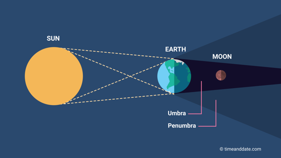
A lunar eclipse happens when the Earth passes directly between the Sun and the Moon, casting its shadow onto the Moon. This only occurs during a full moon.

There are three types of lunar eclipses:

  1. Penumbral Lunar Eclipse – the Moon passes through Earth’s faint outer shadow (the penumbra), causing only a slight dimming.
  2. Partial Lunar Eclipse – part of the Moon passes through Earth’s dark central shadow (the umbra), and a section appears darkened.
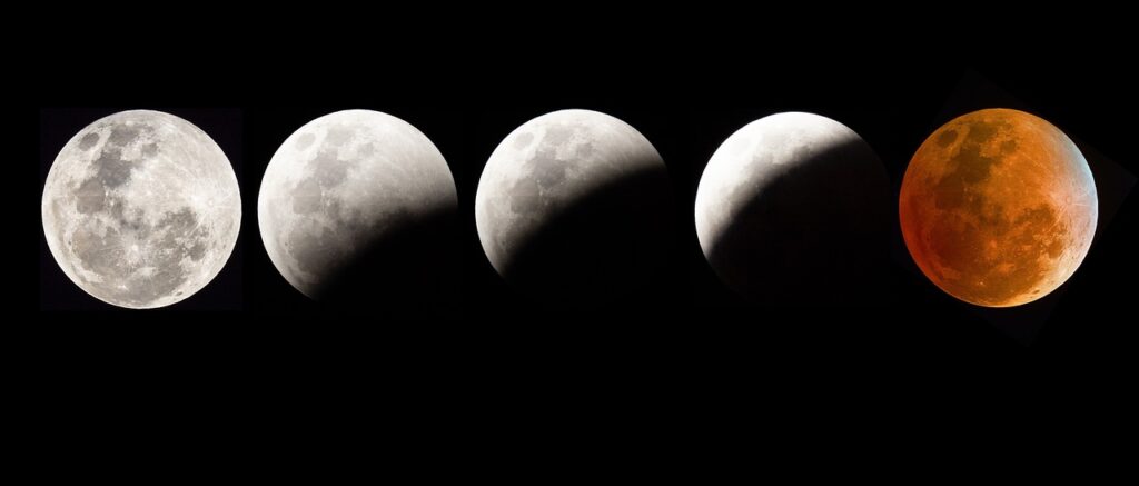
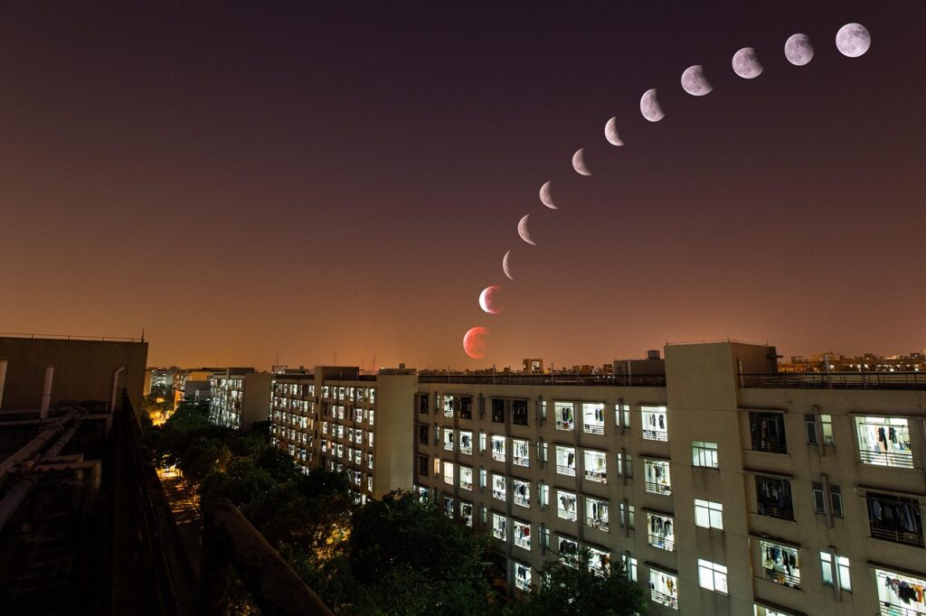
  3. Total Lunar Eclipse – the entire Moon moves into Earth’s umbra, turning a reddish colour — often called a ‘Blood Moon’.


During a total lunar eclipse, the Earth blocks direct sunlight from reaching the Moon. However, sunlight still filters through Earth’s atmosphere and bends (or refracts) around the planet.

Shorter blue wavelengths are scattered, and the longer red and orange wavelengths reach the Moon — causing it to glow red or copper.

It’s the same effect that gives us red sunrises and sunsets — except this time, you’re seeing it reflected back from the Moon!

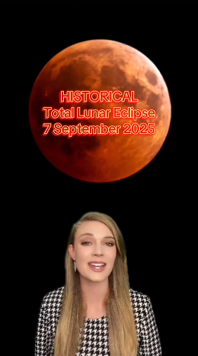
This TikTok video from Michelle shows us more on how lunar eclipses take place – together with a quick weather overview for the country’s stargazing.

The 7 September 2025 eclipse is special because:

  • It will be a total lunar eclipse, with the entire Moon turning red.
  • It will last 82 minutes, making it one of the longest lunar eclipses of the decade.
  • It will be visible across South Africa.
  • No telescope is needed — you can see it with the naked eye if skies are clear.

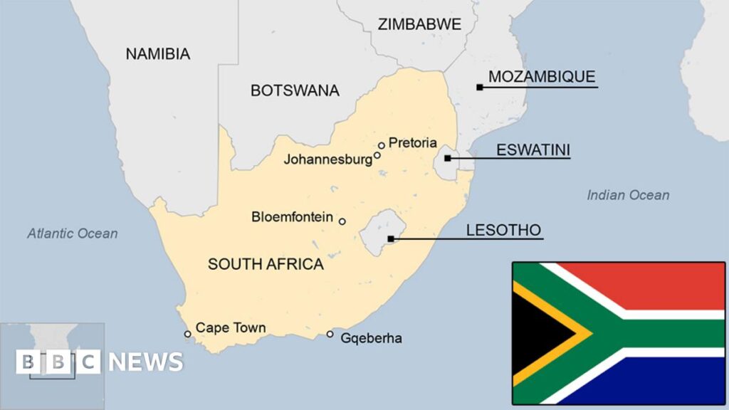
South Africa Viewing Details and Weather Conditions

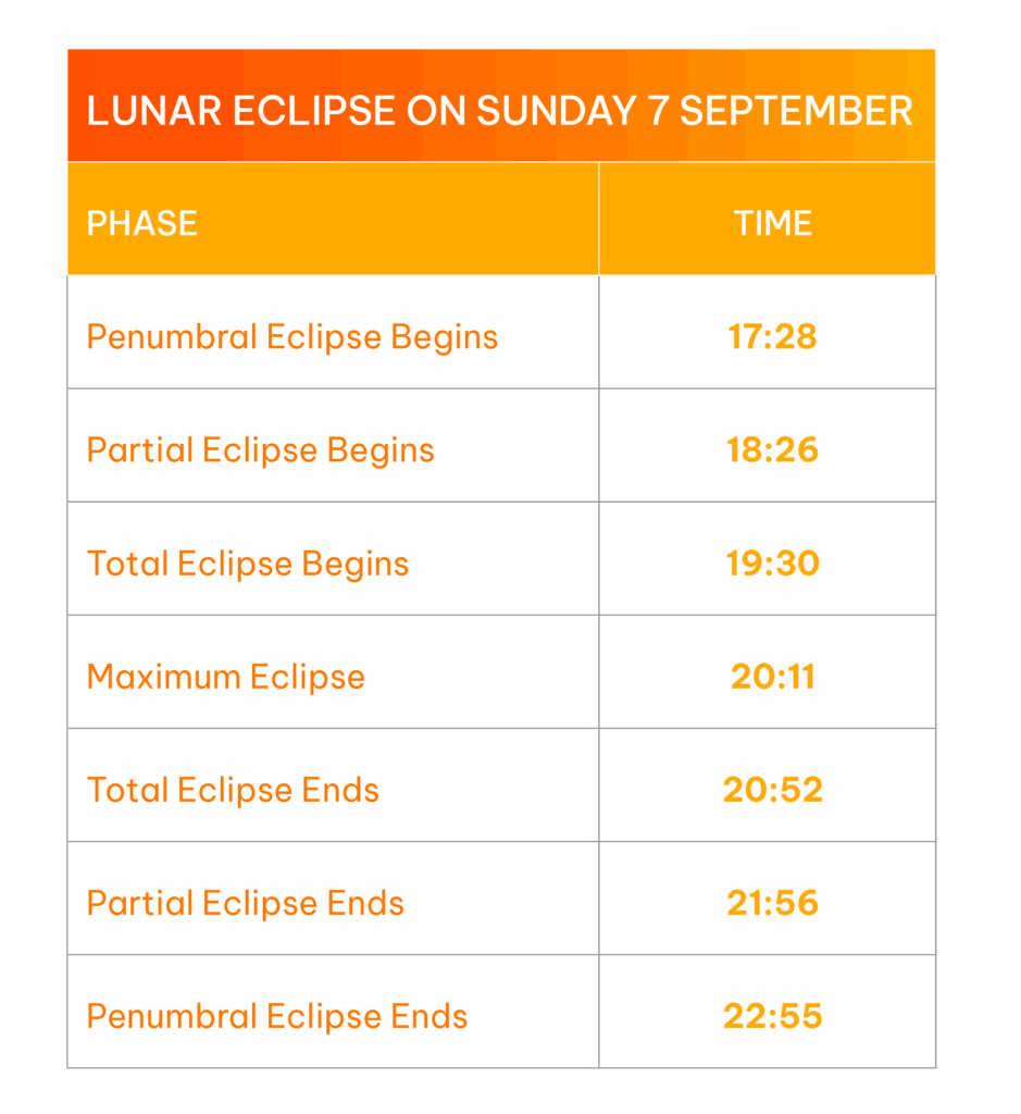
The table shows the key moments to look out for. The best time to watch is between 7:30 PM and 8:52 PM, when the Moon will be completely within Earth’s shadow and glowing red.

The weather conditions for 7 September across the country will be mostly favourable for viewing the total lunar eclipse on Sunday evening.

  • However, around the Southern Cape, including parts of the Garden Route and Overberg, we are expecting widespread cloud cover, which will most likely obscure the view of the eclipse.
  • In contrast, much of the interior, including the Free State, North West, Limpopo, and Gauteng, will experience partly cloudy skies with high to mid-level cloud, allowing for intermittent but generally good visibility of the eclipse.
  • Cape Town is also expected to have clear enough skies, especially earlier in the evening, making for a great viewing opportunity.
  • Coastal areas in KwaZulu-Natal and parts of the Eastern Cape may see some coastal cloud or mist, especially early evening, but breaks in the cloud are possible later on.

For the best view, try to find an open area away from city lights — ideally elevated, with an unobstructed view of the eastern horizon where the Moon will rise.

Tips for Watching and Photographing

  • Dress warmly — it’s still chilly at night in September.
  • Use a camera with manual exposure settings if possible.
  • For smartphone users: Tap to focus on the Moon and reduce brightness for better contrast.


Fun Facts

  • A lunar eclipse can only occur during a full moon.
  • Unlike a solar eclipse, lunar eclipses are safe to view with the naked eye.
  • The Moon doesn’t completely disappear — it turns red due to Rayleigh scattering in Earth’s atmosphere.

Why Is It Called a “Blood Moon”?

The term ‘Blood Moon’ comes from the deep red colour the Moon takes on during totality. Ancient cultures often saw it as an omen, but today we know it’s simply the effect of Earth’s atmosphere bending sunlight.

Mark your calendars and if skies are clear, look up and enjoy the show!

South Africa is one of the few countries in southern Africa that regularly has snow  – in places – in winter.

Vox Weather Meteorologist Michelle du Plessis tells us more.

South Africa’s climatic diversity is largely due to its geographic position at the southernmost tip of Africa, where it’s influenced by both the warm Agulhas Current on the east coast and the cold Benguela Current on the west coast. Its varied topography – ranging from high plateaus to mountain ranges like the Drakensberg – creates conditions cold enough for snowfall in winter. Being the furthest south on the continent, South Africa is also directly affected by mid-latitude cyclones and cut-off low-pressure systems. When looking at our neighbouring countries, clear contrasts emerge in winter weather patterns.

(Image left courtesy Mantle Plumes; Image right courtesy Vox Weather)

Lesotho, though an independent country, is entirely landlocked within South Africa.

Its high elevation – most of the country lies above 1,800 metres – means it experiences regular snowfall in winter, particularly over the Maloti Mountains, much like surrounding high-lying areas of South Africa.

(Photo courtesy Snow Report SA / Marietjie Hayward)

Namibia and Botswana experience dry, sunny winters with cool nights and warm days, but their generally low elevation and arid conditions make snowfall virtually impossible.

In Namibia, bergwinds or “oosweer” often bring warm, dry weather and occasional sandstorms as strong north-easterly winds prevail after the passage of cold fronts. Although rare, light snowfall can occur in the far south of Namibia when a particularly strong cold front moves unusually far north.

Zimbabwe and Mozambique have subtropical to tropical climates. Their winters are dry and mild, with average temperatures rarely dropping low enough to produce frost, let alone snow.

Eswatini experiences slightly cooler conditions in winter, especially in its highland areas, but snowfall is extremely rare due to its lower elevation and more humid climate.

(Map image courtesy of BBC News)

These regional differences highlight how South Africa’s southern location, combined with its topographical range and oceanic influences, makes it uniquely positioned to experience a wide variety of winter weather, including rain and snow – conditions seldom seen in its neighbouring countries.

(Click here to find out how snow weather occurs.)

Forecaster warned that snow is possible in central SA and Gauteng this week. Here is the latest weather update.

Snow in Gauteng? Weather models are pointing to a rare wintry mix for the province this Thursday as a powerful cut-off low sweeps across South Africa, bringing freezing temperatures and the potential for snow, hail, or graupel.

While actual snow settling in Gauteng remains unlikely due to higher ground temperatures, forecasters warn that conditions may be cold and unstable enough to produce soft hail or snow-like precipitation.

GARDEN ROUTE | KAROO NEWS – While snowfall is likely to evade Gauteng, a strong cut-off low will develop over the western part of the country on Wednesday and slowly move eastwards, spreading cold and wet weather over central and later eastern parts of South Africa. 

According to Vox Weather, models are indicating a mix of rain, snow, and graupel is likely over central South Africa (parts of Free State, Northern Cape, Eastern Cape, Lesotho). 

What is happening to SA’s winters and is climate change playing a significant role? Vox Meteorologist Michelle du Plessis tells us more.

Data shows that winter temperatures across southern Africa have been steadily rising since the 1960s, with fewer days of frost and freezing conditions.

According to the NOAA, extreme cold events are now far less common – and when they do happen, they’re generally milder than in the past.

In the Western Cape, where winter rainfall is vital, climate models show that the rainy season is becoming shorter and more variable.

While some winters still bring strong cold fronts and good rainfall, others are marked by long dry spells.

The WMO warns that drought risks are increasing, especially in Mediterranean-type climates like the south-western Cape.

Interestingly, while total rainfall may decrease, when storms do occur, they may be more intense – bringing short bursts of heavy rain rather than steady soaking periods. This is because warmer air holds more moisture, which can lead to more powerful frontal systems when they develop.

Recent studies suggest that mid-latitude frontal systems – the cold fronts that bring winter rain – may grow stronger under climate change. However, this doesn’t mean we’ll get more of them. Instead, we may see fewer, but more intense, winter storms, followed by longer dry periods in between.

What this means for South Africa

In short, South African winters are becoming:

  • Warmer, with fewer frost days;
  • More variable, with rain falling in short, intense bursts; and
  • Less predictable, meaning long-range planning is harder.

Did you know that South Africa has Africa’s second longest mainland coastline – second only to Somalia? 

And of course, as the southernmost country in Africa, with our coastline spanning two oceans, we see a vast amount of shipping all along our coastlines, both domestic as well as international – there are more than 30 000 ships sailing around the country every year.

So let’s spare a thought for the sailors, as strong winds continue to make their presence known regularly around parts of South Africa’s coastal region as the winter progresses, with damaging winds and waves in places along the coast.

 International mariners and local fishermen alike rely on factors such as ship routeing, meteorological data and weather forecasts to plan safe and efficient routes wherever possible.

The South Africa Weather Service (SAWS) issues wind and wave warnings when winds are expected to be strong enough to cause disruptions or damage, or when waves are expected to be high enough to pose a risk. These warnings are crucial for coastal communities and marine activities. 

To look at just two examples, SAWS warned of damaging waves expected south of Durban, Kwa-Zulu-Natal during the second week of June, and again during the weekend of Friday 25 and Saturday 26 July, that could cause disruptions and navigational difficulties. We’re still in the middle of winter, so there’s no doubt that we can expect further warnings around damaging winds and waves coming through in due course.

Here at Vox Weather, we are proud to play our role in sharing information to help keep sailors informed, to assist with their safety, and the safekeeping of their important economic cargoes, as much as possible.

Some early snow forecasts recently circulated on social media suggested possible snowfall over parts of Gauteng, North West, the Highveld, and other areas that rarely experience snow during late July. At Vox Weather, we chose not to post about these projections – and here’s why.

Advanced snow forecasts, particularly more than five days ahead, are often subject to significant change. In fact, updated model guidance today NO LONGER indicates snowfall over these north-eastern regions at all.

Our approach as meteorologists to snow forecasting involves more than just looking at model snowfall outputs.

We analyse:

  • The SYNOPTIC SYSTEM expected (e.g. a cold front or cut-off low);
  • The availability and timing of PRECIPITATION; and
  • The FREEZING LEVELS (the altitude at which temperatures are cold enough for snow to form and reach the ground).

These factors must all align for snowfall to be possible. A shift in any of them can lead to significant changes in where snow may fall – or if it occurs at all.

As of the latest forecast, we see:

  • A cold front expected to move in on Friday 25 July.
  • A strong ridging high-pressure system to follow, introducing colder air over southern South Africa during the weekend of 26 and 27 July.
  • Forecast snowfall now largely restricted to the Eastern Cape, Lesotho, the southern Free State, and adjacent high-lying areas.

At Vox Weather, we prefer to wait until we see consistency in multiple forecast runs – usually within a five-day window – before communicating potential snowfall.


This ensures that our updates are as accurate and reliable as possible.

We saw a brutal start to South Africa’s winter season when a powerful winter storm initially swept across much of South Africa during the week of 09 to 13 June, bringing bitter cold, snow and heavy rain to several provinces, and with it the massive potential to disrupt businesses of all types. Now, we’ve seen even more snowfall during July.

The icy weather that we’ve seen is largely to do with the arrival of ‘cut-off low’ systems, meaning a weather system where very cold air becomes trapped and spins above the country. When the systems are unusually deep, stretching from the upper atmosphere all the way to the ground, this brings especially intense cold, rain and snow.

What impact does this have on business?

Besides the potential tragedy of loss of life for people in transit, extreme weather brings a variety of challenges.

Snow on the N3 generally interrupts supply chains, making it difficult to get goods in transit to businesses. The gale force winds experienced are, of course, disruptive to all travellers, as well as once again affecting supply chains. Gale force winds can also interfere with agricultural production, including causing damage to infrastructure.

We’ve also seen widespread fog and frost over parts of the interior as temperatures hover around freezing point. These particular conditions can also affect business travellers through impaired visibility and more slippery or even closed roads, and potential damage to infrastructure from frost conditions.

Even businesses in parts of the country that experienced less extreme weather can be negatively affected. For example, rainfall in Gauteng in early June and again in July, while not as heavy as within the Eastern Cape or KwaZulu-Natal, would have potentially made the roads slicker, perhaps adding to the risk factors for motorists due to accidents and increased congestion.

As ever, Vox Weather is dedicated to bringing South Africans the latest weather updates to assist everyone across the country in planning their days and weeks.

For now, winter is in full swing and so the usual precautions – dress appropriately, travel with care, take shelter when necessary and carry out contingency planning as required – will apply.

The arrival of snow isn’t an everyday occurrence for most of South Africa.

As we find ourselves back in snow season, we sat down with Vox Meteorologist Michelle du Plessis to give us the lowdown on how snow is formed.

And it turns out that, for snow to fall and reach the ground, three main weather conditions must come together.

Cold air from top to bottom: The air must be below freezing (0 °C) all the way from the clouds to the ground. If there’s a warmer layer in between, the snow will melt and fall as rain or sleet. Ideal snow forms in clouds where temperatures are between -10 °C and -20 °C.

Enough moisture in the air: Cold air alone isn’t enough – you also need moisture so that water vapour can form ice crystals. Dry air, even if freezing, won’t produce snow.

Something to lift the air: Snow usually forms when air is forced to rise, cool, and condense. This can happen with cold fronts, low-pressure systems like cut-off lows, or when air is pushed up over mountains.

Gauteng’s last snowfall: July 2023…

In July 2023, Gauteng experienced rare snowfall – something locals hadn’t seen in over a decade (before 2023 it snowed in 2012 and 1996). While light snow sometimes falls in the province, heavier events like this happen only once every 10 to 20 years. So yes, it was unusual, but not unheard of.

The July 2023 cold snap wasn’t driven by climate change – instead, it was the result of a powerful cold front that swept across the entire country and extended into our neighbouring countries – supported by a steep upper-air trough, pushing icy air far north.

Looking ahead to winter 2025…

We find that the odds of another snowfall in Gauteng remain low. Climate trends suggest snow in the region will become even rarer in future. That said, nature still has surprises.

If the right weather patterns align—such as a strong cold front or cut-off low pressure system – we could see isolated snow again. But it would remain the exception, not the rule.

We take a look with Vox Weather.

We’re definitely deep into cold weather season in South Africa, so we thought it would be a great idea to sit down with Vox Weather and find out what we can expect from Winter 2025.

Why not grab a cup of something hot to drink and see what Vox Weather Meteorologist, Michelle du Plessis, has to say to help us stay prepared?

Q: Please clarify the rough timeline that we use in South Africa to define the winter season?

In South Africa, winter runs from June to August. However, cold weather can begin as early as mid-May and linger into early September. Meteorological seasons are based on calendar months and average annual temperature cycles, making them more consistent for record-keeping and climate analysis.

Q: What does a ‘normal’ winter weather spread look like across South Africa?

South Africa is climatically unique because it experiences both winter, summer and year round rainfall patterns. Let’s take a look, region by region.

Western Cape: Winter Rainfall Zone

 This is the only region in South Africa that receives most of its rain during winter (June – August).

  • This happens due to mid-latitude cyclones or cold fronts that migrate northward during winter, sweeping across the south-western tip of the country.
  • These systems bring cold, wet conditions to areas like Cape Town, the Winelands, Overberg, and parts of the Garden Route, and when the systems are strong enough, the cold also spreads as far north as Gauteng.
  • The region often experiences multiple cold fronts per month, with days of strong wind and heavy rain.


Central Interior (Free State, North West, Northern Cape interior, parts of Gauteng and Highveld): Dry days and Cold nights

  • Dominated by subsiding air from a dominant continental high-pressure system (Kalahari High Pressure System).
  • These high-pressures suppress cloud formation and rainfall, leading to clear skies, dry air and very cold nights.
  • Frost is common, and minimum temperatures often drop below 0°C.

KwaZulu-Natal Coast: Mild and Dry Winters

  •  The coastal belt remains warmer than the interior due to lower elevation and the warm Agulhas Current.
  • Rain usually occurs behind a cold front due to a ridging high-pressure system, but berg winds (hot, dry winds) can cause temperature spikes in winter.
  • Occasional morning mist or light rain may occur, but winters are generally comfortable.

Gauteng: Sunny but Cold Mornings

  • Gauteng is firmly in the summer rainfall zone, so winters are mostly dry, cool and clear.
  • Days are generally mild (17 – 22°C), but nights can be very cold with widespread frost.
  • There is no significant winter rainfall unless an unusual cut-off low develops.

Eastern Cape Highlands, Southern Drakensberg & Lesotho: Cold with Snow Potential

  • These high-altitude areas are the most prone to snowfall in South Africa.
  • Snow is typically linked to strong cold fronts or cut-off low systems that bring enough moisture and drop freezing levels low enough for snow to fall.
  • Towns like Rhodes and Barkly East, and the Mountains in Lesotho can see several snowfalls per season.

Limpopo and Mpumalanga Lowveld: Mild, Dry, and Stable

  • These areas remain relatively warm, with pleasant daytime temperatures and dry conditions.
  • Like Gauteng, they fall in the summer rainfall zone and receive little to no winter precipitation.

The Transition Zone: Where It Gets Complicated

Research by Jennifer Fitchett and colleagues at Wits University (2019) revealed that while most experts agree that Cape Town is in the winter rainfall zone and Johannesburg is in the summer rainfall zone, the boundary between the two is highly disputed.

  • Using over 60 rainfall maps from 1938 to the present, they found no consensus on where the two zones split.
  • Areas like Sutherland are especially complex – some maps classify it as a winter rainfall area, others as summer rainfall, and some as year-round.

Climate Change Impacts

  • Studies show that the boundary between rainfall zones is shifting southwards, driven by the southward retreat of the westerlies (wind systems responsible for cold fronts).
  • This may explain recent droughts in the Western Cape (2015 – 2017) and may result in shorter, more intense winters in the future.

Q: With regards to a ‘normal’ winter weather spread in South Africa, are you anticipating any particularly unusual weather for winter 2025?

Winter remains one of the most difficult seasons to forecast in South Africa. For winter 2025, weather models are offering mixed signals, and there’s currently no strong consensus on what to expect. Some early forecasts suggest slightly wetter conditions in the far southwest, while others lean toward a drier interior. But overall, there’s no clear indication of a highly unusual winter.

In the Western Cape, where South Africa receives most of its winter rainfall, the key drivers are mid-latitude cold fronts and cut-off low-pressure systems – not El Niño or La Niña. The strength and frequency of these systems vary from year to year and are difficult to predict far in advance.


Long-range weather models often struggle to capture these systems accurately, especially when there’s no strong global climate signal influencing the region. While the El Niño-Southern Oscillation (ENSO) is currently in a neutral phase, this has little bearing on the Western Cape, making short-term forecasting the most reliable way to prepare for the season.

Even in a ‘normal’ winter, cold snaps, widespread frost, or periods of intense rainfall can still occur when the right weather patterns line up. So, while there’s no strong evidence yet pointing to a particularly unusual winter in 2025, it’s a season where conditions can shift quickly. Staying informed with short-range forecasts is the best way to be prepared.

Q: Do you see any major red flags for the 2025 winter season?

One important point to keep in mind this winter is that we’re entering the season with higher uncertainty than usual. With weather models not in agreement and no strong climate drivers like El Niño or La Niña to guide long-term trends, conditions could shift quickly.

This means it’s especially important to:

  • Pay close attention to short-term forecasts, particularly for cold snaps, frost, and strong cold fronts.
  • Be prepared for sudden weather extremes, even if the broader seasonal outlook appears ‘average’.
  • Watch for localised impacts, like flash flooding from intense frontal rainfall or damage from strong winds, especially in the Western and Southern Cape.

Also, increased climate variability means that traditional expectations of winter weather may no longer apply. What was once seen as unusual – like snow in unexpected areas, or sudden dry spells during the rainy season – is becoming more common as the climate shifts.

So, while we don’t yet see major red flags for winter 2025, the takeaway is clear: stay informed, stay flexible, and be ready for change.