Why it is still too early to make drought predictions for South Africa

After one of the better rainfall seasons so far across parts of South Africa’s summer rainfall areas, a new concern is starting to draw attention: the possibility of a strong, or even ‘Super’, El Niño later in 2026. This has already raised concern among farmers, agricultural businesses, water planners and other weather-sensitive industries. However, says Vox Weather Meteorologist Michelle du Plessis, it is important to approach the topic carefully.

While the chance of El Niño developing later this year is increasing, it is still too early to make direct drought predictions for South Africa. At this stage, the best message is one of awareness and preparation, not panic. We unpack this in the article.

What is El Niño?

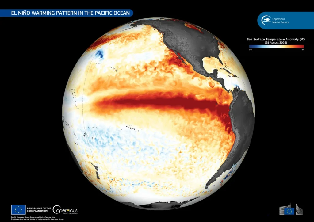
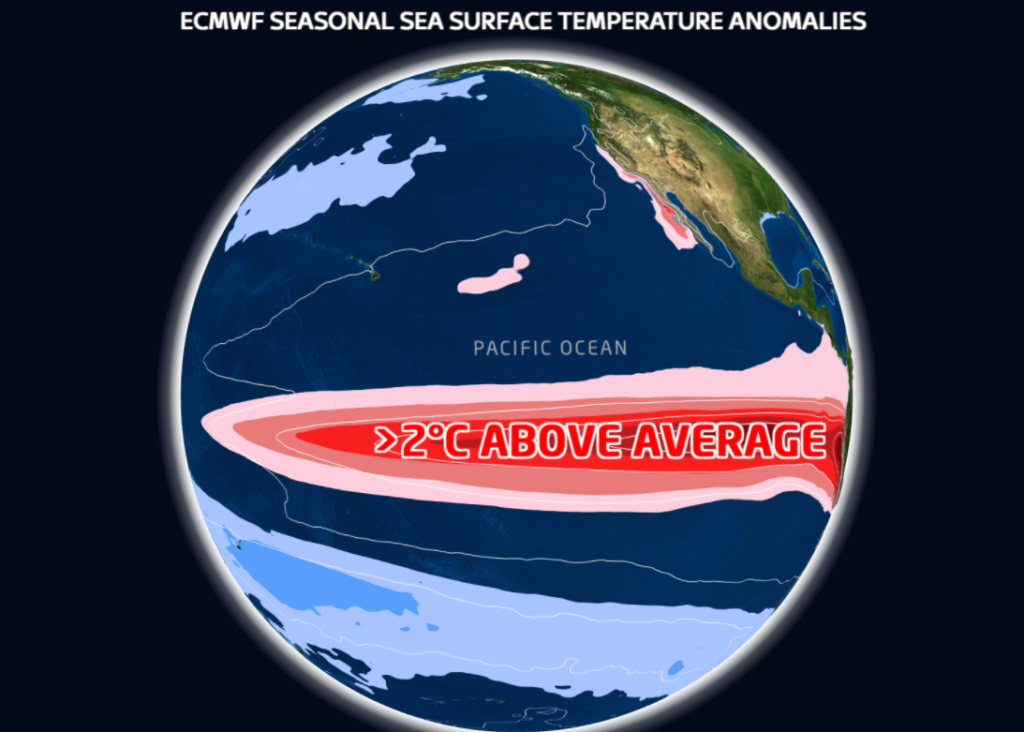
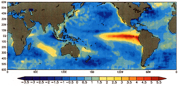
El Niño forms part of the El Niño-Southern Oscillation, commonly known as ENSO. ENSO is a natural climate pattern linked to changes in sea surface temperatures and atmospheric pressure across the central and eastern equatorial Pacific.

During El Niño, sea surface temperatures in the central and eastern equatorial Pacific Ocean become warmer than normal. This warming can influence global weather patterns by shifting large-scale atmospheric circulation. 

In southern Africa, El Niño is often associated with a greater chance of hotter and drier conditions during the summer rainfall season, especially over the interior summer rainfall regions.

However, El Niño does not affect every country or every season in the same way. It also does not automatically mean that drought will occur.

What are the latest forecasts showing?

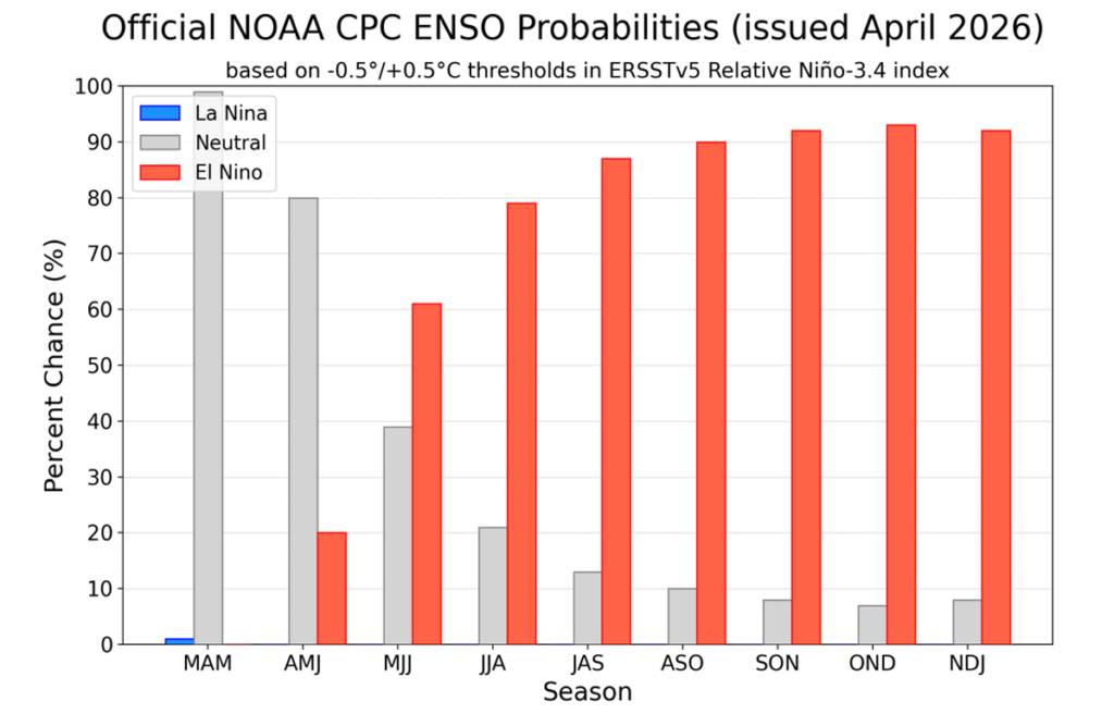
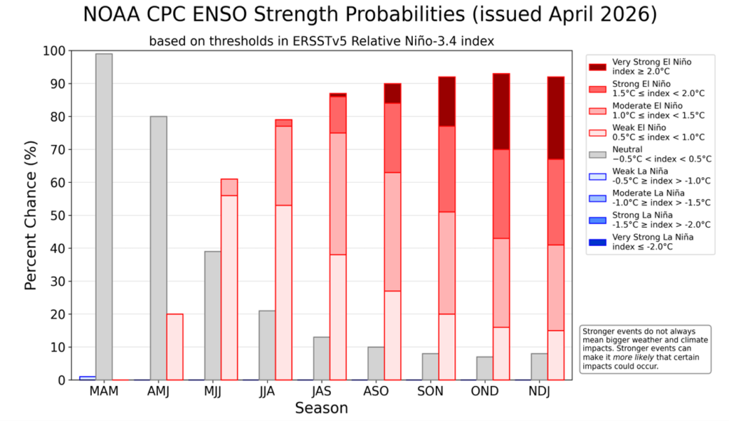
According to the latest outlook from the US Federal Agency, the National Oceanic and Atmospheric Administration (NOAA), ENSO-neutral conditions are currently present, but El Niño is likely to develop during May to July 2026. NOAA gives a 61% chance of El Niño emerging during this period and continuing through at least the end of 2026.

NOAA also indicates a roughly one-in-four chance that the event could become very strong later in the year, but notes that this depends on whether the atmospheric conditions over the equatorial Pacific continue to support further strengthening.

The World Meteorological Organization (WMO) has also highlighted that ENSO-neutral conditions are expected in the short term, while the probability of El Niño increases later in 2026. WMO’s earlier update indicated around a 60% chance of neutral conditions during May to July, with the chance of El Niño rising to around 40% during that same period.

Here at home, the University of Pretoria’s Seasonal Forecast Worx April 2026 update also points towards the possible development of a strong El Niño state towards the end of 2026.

This means there is growing agreement that El Niño may develop later this year, but there is still uncertainty about how strong it will become and how directly it will affect South Africa.

What does ‘Super El Niño’ mean?

The term ‘Super El Niño’ is often used in the media to describe an exceptionally strong El Niño event. In scientific discussions, a very strong El Niño is usually linked to sea surface temperature anomalies in the Niño 3.4 region reaching around +2.0°C or more.

However, ‘Super El Niño’ is not always used consistently. It can sound dramatic, and it can create the impression that severe drought is already guaranteed. That is not the case.

A strong El Niño increases the probability of certain climate impacts, but it does not guarantee the same outcome in every country. For South Africa, the strength of El Niño is important, but it is not the only factor that determines rainfall.

Too early to make drought predictions for South Africa

It is still too early to directly link the expected El Niño to a specific drought outcome for South Africa.

One reason is that ENSO forecasts are generally less reliable during the late autumn and winter months. Forecast confidence usually improves from around August and September, when the Pacific Ocean and atmosphere are more clearly coupled and the signal for the coming summer rainfall season becomes stronger.

This is especially important for South Africa, because the main ENSO-related impacts are usually felt during the summer rainfall season, from around October or November through to March. The current winter period is not expected to be significantly influenced by the developing El Niño signal.

For this reason, any strong statements about drought over South Africa should be treated with caution at this stage. It is more responsible to say that the risk of hotter and drier summer conditions may increase if a strong El Niño develops, but it is not yet possible to confirm the timing, severity or regional detail of those impacts.

South Africa’s rainfall is influenced by more than ENSO

Although El Niño is an important climate driver, South Africa’s rainfall is influenced by several other factors as well.

These include the position of high-pressure systems, moisture transport from the tropics and Indian Ocean, cut-off lows, tropical-temperate cloud bands, regional circulation patterns, sea surface temperatures near southern Africa, and shorter-term weather systems.

This means that even during El Niño years, rainfall can still vary significantly from one region to another. Some areas may experience long dry spells, while others may still receive important rainfall events.

It is also important to remember that only the summer rainfall regions of South Africa are typically more directly influenced by ENSO. The winter rainfall region, especially the Western Cape, is not affected in the same way during winter.

What can we learn from past strong El Niño events?

Historically, South Africa has experienced different outcomes during strong El Niño events.

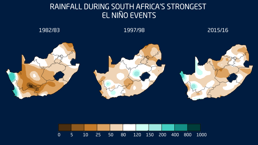
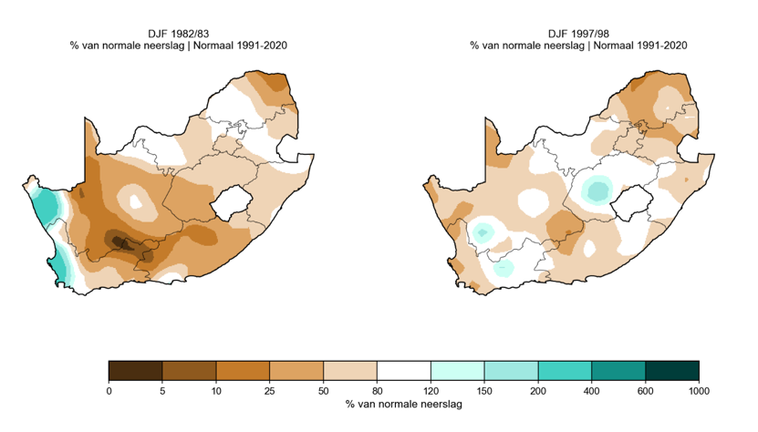
The 1982/83 El Niño was linked to severe agricultural impacts and is remembered as one of the more damaging events for crops. However, the 1997/98 event, although globally one of the strongest El Niño events on record, did not produce the typical widespread hotter and drier summer season over South Africa in the same way.

This shows why we cannot simply say “strong El Niño equals drought”. The relationship is important, but it is not perfect.

El Niño increases the risk of certain conditions, but the final impact depends on how it interacts with other climate drivers during the season.

What could this mean for South Africa if a strong El Niño develops?

If a strong El Niño develops and persists into the 2026/27 summer rainfall season, South Africa’s summer rainfall areas may face an increased risk of warmer and drier conditions compared with normal.

  • For daily life, this could mean a greater chance of heatwaves, higher water demand, increased fire-weather risk in some areas, and pressure on household and municipal water use.
  • For agriculture, the main concern would be the timing and distribution of rainfall during the planting and growing season. Even if seasonal rainfall totals are not extremely low, poor rainfall timing, long dry spells between rainfall events, or very hot conditions during sensitive crop stages can still place crops and livestock under pressure.
  • For weather-sensitive industries such as mining, construction, tourism, logistics and supply chains, a hotter and drier summer could increase operational challenges. These may include heat-related working conditions, dust, water-use pressure, veld fire risk, and possible knock-on effects on agricultural production and food prices.

However, these remain possible risks, not confirmed outcomes.

What should farmers and weather-sensitive industries do now?

The key message is to prepare practically, but not to panic.

Farmers should monitor seasonal updates closely over the next few months, especially from August and September onwards when confidence in the summer outlook should improve. It may also be useful to start reviewing water availability, irrigation planning, planting decisions, fodder reserves, livestock heat-stress plans and financial risk strategies.

At the same time, short-term forecasts remain the most useful tool for immediate decision-making. A possible El Niño later in the year does not replace the need to monitor weekly rainfall systems, cold fronts, cut-off lows, heatwaves and severe weather warnings.

Is climate change making El Niño worse?

El Niño is a natural climate phenomenon. It is not caused by climate change. However, it now occurs in a warmer global climate system.

This means that when a strong El Niño develops, it can add to already elevated global temperatures and increase the likelihood of heat-related extremes in some parts of the world. A strong El Niño in a warmer world can therefore have amplified impacts, especially when it comes to temperature.

For South Africa, this means that if a strong El Niño develops, the heat component may be particularly important to monitor during the 2026/27 summer season.

The key message for South Africa

There is growing evidence that El Niño may develop later in 2026, and there is a possibility that it could become strong. However, it is still too early to confirm a ‘Super El Niño’ or make direct drought predictions for South Africa.

The most responsible message is that the risk of hotter and drier conditions may increase for the summer rainfall areas during the 2026/27 summer season, especially from October or November into March, but this risk still needs to be monitored carefully over the coming months.


For now, South Africans should remain informed, follow trusted seasonal updates, and continue to use short-term forecasts for practical day-to-day planning.

A possible strong El Niño is something to watch closely, not something to treat as a guaranteed drought forecast.

A sturdy and stylish Subaru Crosstrek is helping Vox Weather meteorologists Annette Botha and Michelle du Plessis reach remote and rugged locations more safely for storm and snow chasing, as well as their always-exciting ‘Beyond the Forecast’ episodes.

Vox Weather has entered into a partnership with Subaru Southern Africa, placing an impressive off-road-ready Subaru Crosstrek at the disposal of Annette and Michelle. The vehicle proudly carries Vox Weather branding on its doors, making it easily recognisable on the road and in Vox Weather content.

The partnership expands the team’s ability to report from remote and challenging locations, while improving safety for the presenters and crew members.

For Vox Weather, the car is more than just a marketing asset. It is a practical tool that changes what the team can do on location. Annette and Michelle enjoy filming outside broadcasts, storm and snow chases, and feature pieces for Vox Weather’s ‘Beyond the Forecast’ series. These segments can take the crew over gravel tracks, steep terrain and into adverse weather.

“Our horizon has expanded when it comes to storm and snow chasing, or any video concept that we want to shoot outside, because we now have the right vehicle to take us there,” says Annette.

She outlines the kinds of assignments the team can now tackle with greater confidence: “Michelle and I can go storm chasing and snow chasing during cold fronts in Cape Town this winter, and drive much more easily on gravel roads for our ‘Beyond the Forecast’ episodes,” she explains.

“We feel so safe in the Subaru Crosstrek. It allows us to embrace opportunities that previously would have required more caution, or might even have been beyond our scope. We are excited to think in ways that are a little more extreme and adventurous, because there is so much more that we can do now with the right vehicle to take us there.”

Subaru builds vehicles designed to give drivers confidence in all weather conditions, and the collaboration with Vox Weather is a great platform to show people the value of its technology, particularly the Symmetrical All-Wheel Drive system.

Annette adds: “The vehicle’s on-board modes also make it versatile. Drivers can choose settings tailored for light snow and gravel, or for mud and more extreme snowy conditions, allowing the car to adapt quickly to changing terrain without compromising on performance.”

She says Vox Weather will feature the vehicle in regular content, including short social reels, on-location intros and select ‘Beyond the Forecast’ episodes.

“We are so grateful to Subaru for trusting us with this Subaru Crosstrek and giving us the chance to take on more extreme and exciting adventures. This is more than just a vehicle. It is a partnership built for the road, for the elements and for the journey ahead, because when the weather changes, we move with it.

“Michelle and I feel confident in this car and safe, not to mention stylish, with the stunning Vox Weather branding combined with the vehicle’s Sand Dune Pearl colour. We look forward to driving in the rugged areas of our beautiful Western Cape. Don’t forget to hoot and wave if you see us!”

We saw eight weather warnings in place recently as a second, and stronger, cold front moved over the south-western Cape in quick succession, bringing damaging winds and disruptive rain. Vox Weather Meteorologist Michelle du Plessis shares a short overview.

(Cover image courtesy of SABC News: Facebook)

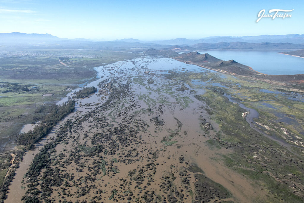
Two consecutive cold fronts moved across the south-western parts of South Africa this week (10 to 15 May), bringing widespread heavy rain, damaging winds and major disruptions across parts of the Western Cape.

The first cold front moved through on Sunday the 10th of May, followed by a second and stronger system on Monday the 11th. This second front brought the most intense weather, with heavy rainfall continuing into Tuesday the 12th across several areas.

Widespread Flooding and Disruptions

Rainfall totals were particularly significant across the western and south-western parts of the province. Several public reports indicate very high accumulations, including around 213 mm near Piketberg by Tuesday morning, with rain still continuing at the time of the report.

In the Koue Bokkeveld, between Ceres and the Cederberg, some areas reportedly received up to around 280 mm, with ongoing rain, road closures, power outages, limited internet access and cellphone tower disruptions being reported.

Some areas may even have received more than 300 mm, particularly some of the mountainous regions.

These very high totals led to widespread flooding and disruptions, with several schools in the Western Cape closed on Tuesday due to the severe weather conditions.

Damaging Winds

The heavy rain was not the only major concern. Damaging winds were also a significant component of this system.

Official 24-hour wind gust observations for Tuesday showed gusts of 117 km/h at Beaufort West and Ladismith, 113 km/h at Ngqura, 109 km/h at Cape Point, 100 km/h at Sutherland, 98 km/h at Dohne, 94 km/h at Hermanus, 93 km/h at Laingsburg, and 91 km/h at both Cape Town AWS and Uitenhage.

Some private weather station reports indicated even stronger gusts, including a reported maximum wind gust of 142 km/h near Piketberg.

These strong winds contributed to widespread damage, including power outages, fallen trees, infrastructure damage and transport disruptions. The closure of the N1 towards Cape Town near Worcester was particularly significant, as it affected a major transport route into the city and likely disrupted the movement of goods and services. A number of flights from the Cape Town and George airports were also affected.

Nature Unleashed

This event highlights the tremendous potential impact of winter cold fronts when multiple systems move through in quick succession. The combination of saturated ground, persistent rainfall, strong winds and rough conditions can quickly lead to flooding, infrastructure damage, travel delays and power supply challenges.

Although strong cold fronts are a normal part of the Western Cape winter rainfall season, this event was particularly significant because of the intensity of the second front, the high rainfall totals over a short period, and the widespread damaging winds.

Conditions are expected to improve from Wednesday as the second cold front moves away from the province. The latest forecast currently indicates dry conditions across most regions of the Western Cape for the rest of the week.

With summer now firmly behind us, what lies ahead for South Africa during Autumn 2026?

Vox Weather Meteorologist Michelle du Plessis first looks back at the sometimes-extreme weather in February, and unpacks what we can expect for the beginning of the forthcoming cooler months.

(Featured image: View of Emmarentia Dam, Johannesburg, during Autumn)

South Africa experienced an extraordinary February 2026, marked by record rainfall in parts of the country, severe thunderstorms, intense heat, and stark regional contrasts in rainfall patterns. While the western and southern parts of the country received widespread above-normal rainfall, the north-eastern regions experienced a warmer and drier end to the summer season.

As Autumn begins to settle across the country, attention is now turning to the seasonal outlook and the possible influence of a developing El Niño later in the year.

February 2026: Record Rainfall and Severe Weather

February brought much-needed rainfall to large parts of the drought-stricken Cape provinces. Rainfall anomaly maps clearly show the regional contrast across the country: the north-eastern interior experienced a hotter and drier end to summer, while the Western and Eastern Cape saw significantly wetter conditions.

Not only did above-normal rainfall occur, but several rainfall records were also broken during the month. These events were largely driven by at least three strong cut-off low pressure systems that moved across the country, producing widespread rainfall and severe thunderstorms.

One notable event occurred in Kakamas, where more than 100 mm of rain fell on 22 February. Later in the month, Grahamstown also recorded exceptional rainfall when its February 24-hour rainfall record was broken. More than 75 mm fell within only a few hours on 24 February, exceeding the previous record by more than 33 mm.

Across social media, numerous photographs and videos captured the dramatic turnaround in water availability, with farmers and residents expressing gratitude for the long-awaited rainfall.

In Ladismith, the situation at the Tierkloof Dam highlighted the dramatic impact of the rainfall. On 2 February 2026, the dam was so depleted that the local municipality had to close the outlet valves to protect infrastructure. After heavy rainfall on 9 February, however, the dam began overflowing within just a week — an extraordinary turnaround.

Rivers also responded rapidly to the rainfall. By 11 February, the Vis River was flowing strongly again, while in George the well-known Pepsi Pools experienced strong runoff following the rains.

Unfortunately, the severe weather also brought destructive storms. Hailstorms in the Southern Cape caused significant damage to fruit farms in the Langkloof region, highlighting the dual nature of intense summer rainfall events.

February was not only wet in parts of the country, but also exceptionally hot. Above-normal temperatures were recorded across the eastern and southern regions.

Cape Town once again broke its maximum temperature record when temperatures soared to 44°C on 16 February.

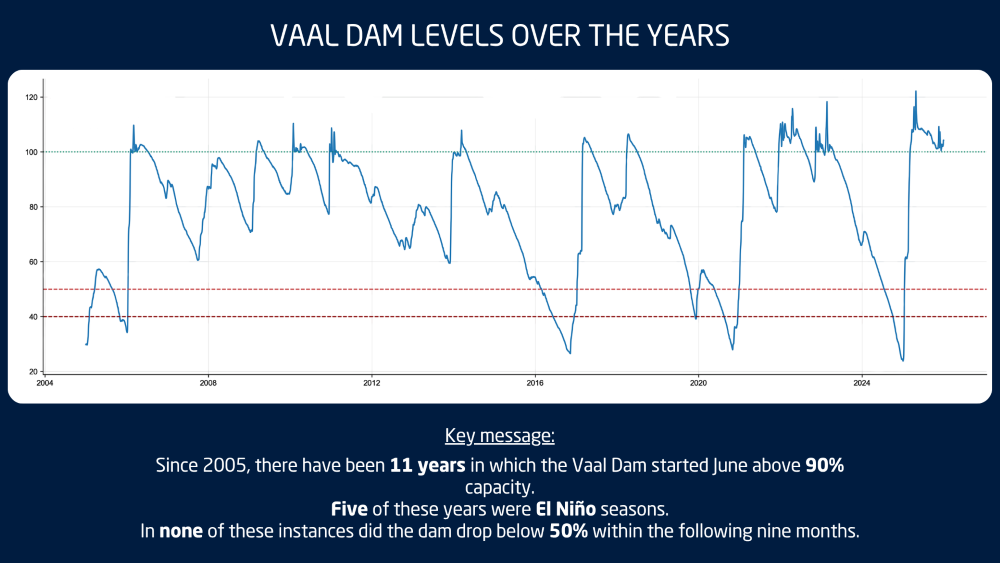
Elsewhere in the country, farmers in the Free State welcomed the rainfall ahead of the harvest season, with crops appearing particularly healthy this year. The Vaal Dam also remains exceptionally full, and there is even the possibility that it could remain at or near full capacity for an entire year — something that may not have occurred in the past two decades, and possibly even longer.

Despite these positive developments in parts of the country, dam levels in the Cape provinces remain a concern.

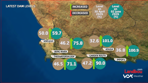
Dam levels in the Western and Southern Cape are currently significantly lower than they were at the same time last year. The Kouga Dam currently stands at only 39% capacity compared to 84% a year ago, while the Theewaterskloof Dam is approximately 50% full compared to 70% at the same time last year. Across the Western Cape as a whole, the average dam level currently sits at around 49.7%, compared to 65.8% a year ago.

Autumn Arrives with the First Cold Front

Autumn has also made an early appearance across parts of the country. The first strong cold front of the season swept across South Africa at the start of March, bringing much cooler conditions. On the morning of 2 March, light frost was recorded in parts of the interior, with temperatures in Sutherland dropping to near and even below freezing.

However, it is important to note that an early frost or early cold conditions do not necessarily mean that the coming winter will be colder or wetter. For this reason, forecasts currently focus primarily on the Autumn outlook rather than drawing conclusions about the winter season.

ENSO Outlook and the Possibility of El Niño

Current projections indicate that the ENSO system is likely to return to a neutral state during Autumn. Some models suggest that conditions could then shift relatively quickly toward an El Niño phase later in the year, potentially developing toward the end of winter and continuing into summer.

If this scenario materialises, it could have implications for rainfall patterns during the next summer rainfall season. However, it is still too early to determine the exact impacts of a potential El Niño event.

Interestingly, if El Niño development is delayed until later in the year, it could even allow for favourable spring rainfall conditions before the event fully establishes itself.

Seasonal Outlook and Model Uncertainty

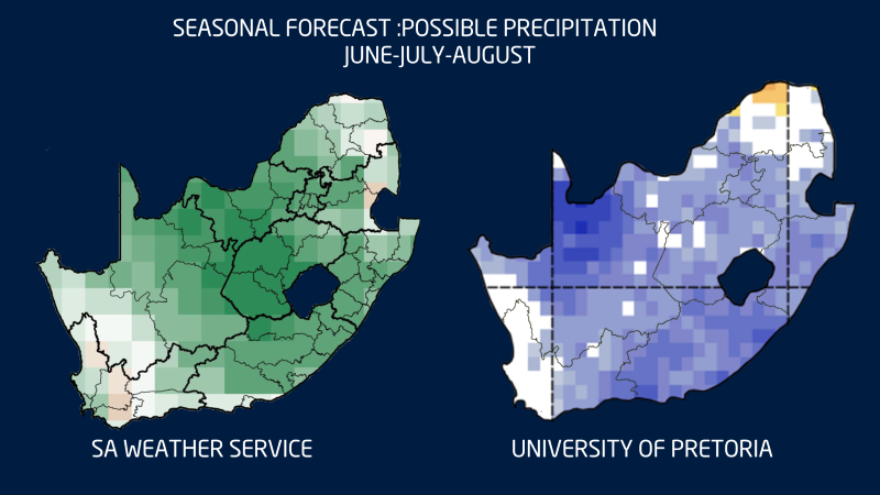
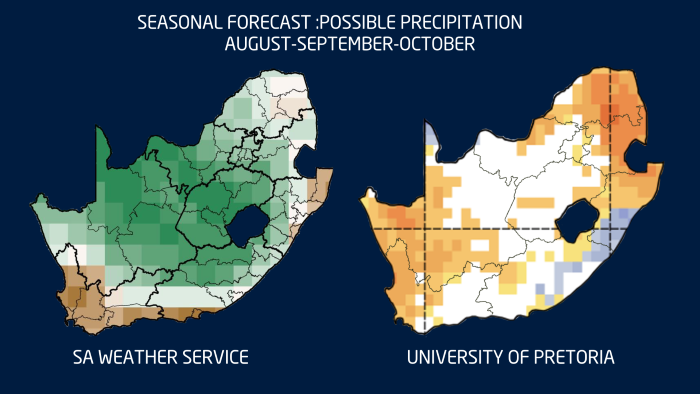
At present, both the South African Weather Service (SAWS) and the University of Pretoria’s seasonal forecasting models indicate the possibility of above-normal rainfall over parts of the interior during the next three months. The signal is particularly strong over sections of the Eastern Cape.

However, both modelling systems also suggest the potential for drier-than-normal conditions over the western parts of the Western Cape and along the West Coast.

It is important to keep in mind that the predictive skill of rainfall forecasts is currently weaker for the western regions of the country, which means the outlook for these areas remains more uncertain.

Seasonal temperature forecasts for March, April and May also indicate a strong likelihood of warmer-than-normal conditions across much of the country. When combined with berg wind conditions, this could increase the risk of veld fires in some areas.

Looking further ahead toward winter, the various climate models do not currently agree on a clear rainfall signal. As a result, no firm conclusions should be drawn yet regarding the coming winter rainfall season.

This uncertainty is worth highlighting because last year both the SAWS and University of Pretoria models predicted below-normal rainfall for the winter rainfall region. In reality, the outcome differed somewhat. The far western parts of the country experienced more rainfall than predicted, while the models were more accurate over the central Karoo and parts of the Southern Cape where below-normal rainfall did occur.


A Season of Change

Across the country, the subtle signs of seasonal change are becoming more noticeable. Leaves are beginning to turn colour, the sun sets earlier in the evenings, and many people have already felt the first bite of cooler air in the mornings.

Autumn in South Africa brings mild days, cool nights and frequent morning mist. It’s the peak season for harvesting grapes as well as other fruit, with vineyards and orchards changing colour and offering scenic views. Elsewhere we find kilometres and kilometres of cosmos flowers in bloom.

And so Autumn remains one of the most pleasant seasons in South Africa, with moderate and comfortable weather across much of the country. Yet for many in the Cape provinces, the hope remains the same: that this Autumn will bring the rainfall needed to replenish reservoirs and provide relief ahead of the winter months.

Feeling like a season was extreme, and proving that it actually was extreme, are two different things. Vox Weather Meteorologist Michelle du Plessis takes a look at our recent summer season.

Let’s Look at the Data

Every summer, without fail, we hear it:

“This must be the worst summer ever.”
“It’s never been this hot.”
“I’ve never seen storms like this.”

And honestly – after a season of severe thunderstorms, flooding, heatwaves and damage – it’s completely understandable why people feel that way.

But here’s the important thing: feeling like a season was extreme and proving it was extreme are two different things. So we went back to the data – and what we found is fascinating.

Some regions genuinely did experience extreme, near-record (and even record-breaking) conditions. Others felt intense impacts without necessarily breaking long-term records.

Let’s unpack it.

Lowveld: One of the Wettest Summers Since 1979

The Lowveld recorded 528 mm of rainfall this summer.

That’s nearly 200 mm above the long-term average of 332 mm. In percentage terms, that’s 158% of normal rainfall.

When we rank every summer since 1979, only two were wetter:

1996 (647 mm)
2000 (591 mm)

That makes summer 2025/26 the 3rd wettest summer in nearly half a century.

So if you’re in Limpopo or parts of the Lowveld and it felt relentlessly wet – that’s not just perception. The data confirms it. This was genuinely one of the wettest summers on record for the region.

Upington: Hottest Summer on Record

Now let’s talk heat.

Upington recorded a mean summer maximum temperature of 37.36°C.

That’s +1.90°C above the 1991–2020 average.

When we ranked all summers since 1979, 2025/26 came out at number one.

Yes — the hottest summer on record in the CPC dataset.

This wasn’t just a few blistering days. It was sustained heat across the entire season. That’s what pushes a summer into record territory.

If you were in the Northern Cape and felt like this was next-level heat – the data agrees.


Richards Bay: Among the Hottest

Richards Bay didn’t break a record, but it came very close.
The mean summer maximum temperature was 30.28°C – about +1.46°C above normal.

That ranks as the 4th hottest summer since 1979.

Top four in nearly five decades is not small. It tells us this was clearly among the warmer summers on record for the region.

What the Temperature Anomaly Map Shows

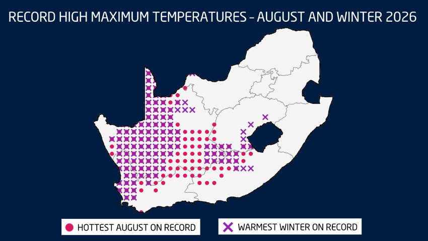
If you look at the maximum temperature anomaly map, the story becomes even clearer. Large parts of the western and central interior are shaded in oranges and reds, indicating widespread above-normal maximum temperatures – in many areas between +1°C and +2°C above the 1991-2020 average. The Northern Cape stands out strongly, which aligns perfectly with Upington’s record-breaking summer.

Interestingly, parts of northern Limpopo show slightly cooler-than-normal anomalies. That helps explain why not every region felt the same level of heat intensity.

The map highlights something important: this was not a uniform heatwave across the country. Instead, it was a regionally amplified heat season, strongest over the western interior and parts of the Eastern Cape, while some northeastern areas were closer to average.

Rainfall: Below Normal in Many Areas – But Storms Were Intense

Now here’s where it gets interesting.

The rainfall map shows that many central interior regions actually recorded below-normal seasonal totals.

But that doesn’t mean the storms weren’t severe.

We saw multiple well-organised severe thunderstorm outbreaks this summer. There were mesoscale convective systems, large hail events, damaging winds and localised flooding.

Seasonal totals can sometimes hide intensity.

You can have:

  • Fewer rainfall days
  • Lower overall totals
  • But more intense rainfall events

And that’s exactly what parts of the country experienced.

So when people say, “The storms were worse than ever,” they’re reacting to intensity and impact – not necessarily total rainfall accumulation.

Perception vs Reality

This is why analysis matters.

Every season feels extreme when you’re living through it. The impacts are visible. The discomfort is real. The damage is real.

But ranking and long-term comparisons help us separate perception from measurable climate extremes.

So was it “the worst summer ever”?

Not everywhere.

But in some places, it absolutely ranks among the most extreme in nearly 50 years of records.

Vox Weather puts the ‘we’ back into weather, assisting both individuals and businesses

As South Africa grappled recently with the extreme weather across the country this summer, its citizens were more invested than ever in following daily weather forecasts. Local viewers – and even some in neighbouring SADC countries – have been following the solid expertise and skilled presentation of Vox Weather’s popular Meteorologists, Annette Botha and Michelle du Plessis, in rapidly increasing numbers. Vox Weather is conveniently presented on multiple platforms including its home web page as well as Facebook, YouTube, X, Instagram, WhatsApp, TikTok and LinkedIn.

Vox Weather was launched and managed by telecommunications and IT services provider Vox some four and a half years ago, in late 2021. Its rapidly climbing follower numbers are a testimony to this daily presenter-led weather update, which provides facts and scientific forecasting with warmth and style.

We take a closer look at how Vox Weather has become another successful subsidiary of Vox, and the important role that personal weather forecasts play in citizens’ lives, as well as facilitating strong businesses and regional economies.

Vox Weather also offers a partnership with agricultural media Landbou.com, providing important weather information to its readers in the agricultural sector, as well as Momentum Insure within the insurance arena. Vox Weather developed a Severe Storm Risk Map specifically for its collaboration with Momentum Insure, which aligns well with the severe storm season South Africa is currently experiencing.

Vox Weather: ‘We are Go for Growth’

Vox Weather achieved its first significant milestone when it grew to 50,000 followers within its first six months of launching. After this, the platform took just another year to double up to 100,000 dedicated followers, with a reach of close to two million people per month, on average, in its first 18 months. Last year, Vox Weather crossed the half-a-million viewers mark – truly impressive!

Vox believes that there are multiple reasons for this pleasing growth. Its presenters are both highly qualified scientists, bringing enormous credibility to their weather presentations, and preparing the visuals themselves from the raw data. In addition, they are personable and friendly, with a truly empathetic understanding of how important the weather is in people’s daily lives.

The animated graphics are professional, modern, visually pleasing and easy to understand. Finally, Vox Weather makes excellent use of multiple social media platforms to actively market its content.

Vox Weather’s social media numbers have recently achieved some additional milestones.

Vox Weather started 2026 on a strong note, with a reach of 7.3 million and 12.9 million views. Having previously reached 500,000, as outlined, Vox Weather’s audience is now sitting at 594 647, gaining 15 300 followers in January. A behaviour measurement tool on WhatsApp shows that audiences are sharing the content more than simply reacting to it, which is an additional win.

It couldn’t be easier to access Vox Weather reports via the platform of your choice, whether you are in the office with your laptop, or on the go and looking at your mobile phone. This has been particularly useful for viewers this past summer as multiple weather events and patterns across the country continued to surprise the country with their intensity.

Vox is very pleased that the forecasts brought by Vox Weather are able to assist people and their personal safety, at the individual level, by giving them the knowledge to potentially avoid dangerous situations involving hailstones, high UV indexes, flooded areas and high winds, to name but a few.

The Importance of Weather Commentary

Locally, every province in South Africa has recently had its own collection of stories to tell about recent weather patterns. Vox Weather’s Meteorologists were ever ready to unpack the facts, present forecasts and communicate warnings when the weather was heading once more into extreme territory.

Annette explains: “Weather forecasting models are designed to predict various weather phenomena such as sunshine, rain, snow, wind and severe storms like thunderstorms and hurricanes. Different models and data are used for different planning needs, including forecasts for aviation, marine activities and fire hazards.”

She notes that prediction timeframes include short-range (hours to days); medium-range (three to seven days); and long-range forecasts (eight to 14 days predictions), and that longer seasonal forecasts also have an important role to play in the planning aspects of certain industries.

Annette continues: “We have seen residents in parts of the Eastern Cape battling with the looming threat of a lack of water supply due to drought conditions, while the Free State experienced massive hailstorms and even tornadoes. In contrast, the Western Cape battled extreme dryness and wildfires, and in the north, residents of Mpumalanga and Limpopo braved deadly floods, including in the Kruger National Park.”

Michelle adds: “When we think about the recent floods in the Kruger National Park, we know that rivers don’t rise slowly. Rain that falls hundreds of kilometres away can rush downstream, filling river channels in hours. That’s why flood warnings matter, and why you should never underestimate moving water. Nature is beautiful – but it’s also incredibly strong, as we have seen all summer long!

“All these wide-ranging weather-related issues have had a potential impact on people’s lives, with awareness of forecasts being even more important for both individuals and businesses alike during times of extreme weather events.”

Weather’s Economic Impacts

Seasonal and long-range forecasts are important for industries with high capital investment and/or long production cycles, as well as those that can be highly sensitive to climate, weather or economic trends. Key industries that rely on longer-term forecasts include agriculture, of course, as well as transportation and logistics, construction and real estate, and insurance and reinsurance, to name but a few.

Vox believes that during challenging economic times, it’s even more important for companies and industries to have an awareness of potentially threatening weather conditions that could have an impact on their operations, and here again Vox Weather is able to assist businesses as well as individuals.

Overall, Vox Weather has seen a strong start to 2026, with a healthy reach and constant engagement. As the parent company, Vox is proud to have played a role in bringing the dynamic duo of Annette and Michelle to South Africa’s social media reach across multiple technology platforms, and looks forward to its continued growth throughout the rest of the year.

When you look at recent weather maps of South Africa, you could be forgiven for thinking that we are living in two different countries. Vox Weather Meteorologist Michelle du Plessis shares the first seasonal outlook of 2026.

Please note: All graphs and images are taken from the latest Langtermyn Landbou-Weervoorspelling, and the text on the visuals is in Afrikaans. You can also view the Landbou show here.

The first agricultural weather outlook of 2026 begins with a country already deeply shaped by summer weather extremes. While large parts of South Africa experienced intense thunderstorms, flooding and high humidity in December, the western regions faced the opposite: extreme heat, dryness and severe fire danger.

The key question now is whether December was just a noisy outlier, or whether it signals a broader pattern for the rest of summer and early autumn.

December 2025: A month of extremes

According to the CPC percent-of-normal rainfall map for December 2025 (based on the 1979–2024 climate period), a classic summer contrast emerged across the country.

The northern, central and eastern regions recorded above-normal rainfall, while the south-western and western areas — particularly the Western Cape, southern Cape and parts of the Northern Cape — were much drier than normal.

Although the Western Cape normally receives most of its rainfall in winter, 2025 was exceptionally dry. It now ranks among the three driest years of the past four decades for the province.

Severe convective storms in the north and east

The above-normal rainfall across the summer-rainfall region was driven by powerful cumulonimbus thunderstorms. These towering cloud systems are responsible for lightning, hail, intense downpours and flash flooding.

Large parts of the northern and eastern provinces saw repeated thunderstorm outbreaks. A particularly shocking event occurred in the Majaneng area near Hammanskraal, where reports indicated that around 40 people were struck by lightning around 3 January.

Several storms also produced large hail, causing localised agricultural and property damage. Flooding was widespread in areas where storms repeatedly tracked over the same catchments.

In the Lowveld, impacts became severe. On 3 December, a vehicle carrying eight people was swept away at the Komatipoort low-water bridge by the swollen Nkomazi River, highlighting how deadly summer river crossings can become.

On New Year’s Day, two tornadoes were confirmed in Mpumalanga, near Middelburg and Carolina, causing damage to buildings and infrastructure.

Extreme fire season in the west

While storms dominated the east, the western parts of the country endured heat, strong winds and very little meaningful rainfall. This combination triggered one of the most severe fire seasons in years.

These fires occurred while the southern Cape was already under severe water stress. Knysna entered Level 4 water restrictions, with only days of usable water left in the Akkerkloof Dam. Rainfall records show that 2025 was the driest year in over 40 years for the area, pushing the town dangerously close to so-called Day Zero.

Disaster management confirmed that at least 10 major wildfires burned over a single intense week, destroying approximately 90,000 hectares and damaging dozens of structures.

What ENSO is telling us

The latest ENSO indicators continue to show La Niña conditions persisting through the rest of summer. These are expected to weaken into neutral conditions during autumn, while the probability of El Niño increases toward late winter and early spring.

For agriculture, this suggests:

  • Above-normal rainfall risks continue in the east during late summer
  • More variable conditions into autumn
  • A growing risk of warmer and drier conditions later in the year as El Niño develops

Water resources under pressure

The Western Cape’s dam levels currently average 66.3%, down sharply from 86.5% at the same time last year. This significant drop highlights how vulnerable the region already is before the winter rainfall season even begins.

In the Eastern Cape, dam levels also remain below last year’s levels, averaging 75.4% compared to 81.3% a year ago. Although the Eastern Cape forms part of South Africa’s year-round rainfall zone, this does not mean rainfall is evenly distributed. Over recent months, most of the rain has fallen further north and east, with major systems missing much of the southern and eastern Cape. This explains why, despite its climate, the region is still under water pressure.

What this means for the months ahead

December was not an isolated event. It reflects a broader climate pattern of:

  • Wet, storm-prone conditions in the east
  • Hot, dry and fire-prone conditions in the west
  • The seasonal outlook suggests this contrast is likely to persist through late summer and early autumn.

For farmers, this means that in the east and Lowveld, there is continued risk of flooding, crop disease and soil erosion; while in the west, there will be ongoing pressure on water resources, fire management and drought planning.

Seasonal models cannot predict individual storms, but they do provide reliable guidance on overall trends. And the trend for early 2026 is already clear:
A wet east, a dry west, and significant agricultural challenges across both.

Vox Weather Meteorologist Annette Botha gives us the details on the 2025 / 2026 summer season – looking back on some of the drama that the weather has recently thrown at us, and what we can expect going into next year.

You can also click here to see Annette presenting this information in a short video in Afrikaans, as part of the regular ‘Langtermyn Landbou-Weervoorspelling’ series, and experience some spectacular additional video footage of recent weather-related visuals that are highlighted here.


South Africans have just come through one of the most dramatic Novembers in recent years – it was a month marked by relentless thunderstorms in the north and east, with widespread hail, local flooding, and strong winds in the Western Cape.

Now, as we turn the corner into December, the latest seasonal forecasts point to a summer of strong contrasts: wet, stormy and cooler in the east, but hot, windy and fire-prone in the west.

A Record-Breaking End to Spring

November delivered an onslaught of thunderstorms across Gauteng, Limpopo, North West, the Free State and the drought-stricken Eastern Cape. Many large dams responded quickly: the Vaal, Gariep and Bloemhof Dams rose sharply, with several spilling over.

Thunderstorms were fuelled by unstable, moisture-rich tropical air that repeatedly surged across the interior. More than one EF0 tornado was reported in parts of the Free State, a reminder that South Africa’s ‘tornado corridor’ can produce short-lived but destructive events almost every summer.

Hail was another standout feature of the month. In some towns, small hail accumulated so thickly that streets resembled winter scenes, trapping cars and residents. In other areas, hail the size of chicken eggs caused extensive damage to vehicles, roofs, gardens and crops. Farmers across the Free State and neighbouring regions faced the difficult balance of ‘good rain, but big losses’.

Meanwhile, in dramatic contrast, the Western Cape battled powerful southeasterly winds, fanning multiple wildfires across the Cape metro and agricultural zones. Homes were evacuated and producers faced early-season challenges with wind damage, low soil moisture, and fire risk.

How Much Rain Actually Fell?

November did not just feel wet, it was exceptional. Large areas of the summer rainfall region recorded more than 150mm for the month, with pockets exceeding 200mm. To put this into perspective: Pretoria’s long-term November average is around 90 mm. Many regions received more than double their normal rainfall.

While the interior soaked, the Karoo, Eastern Cape and Western Cape experienced a notably drier spring, aligned with the persistent windier pattern that dominated the southwest.

December Wind Outlook: More Gusts on the Way

November 2025 was confirmed as the windiest November since 1995 over the Western Cape based on 30-year wind-speed averages.

Unfortunately for Capetonians, the models show continued above-normal windiness in December.

This raises wildfire danger even further heading into the heart of the festive season.


Dams, Climate Drivers and What is Shaping the Season

Dam levels remain high across the interior and are expected to climb further with continued rainfall. In contrast, dams in the Western and Southern Cape are dropping quickly, with some municipalities already preparing for potential water restrictions.

Globally, the climate system is reinforcing the wet-summer signal. We remain in La Niña conditions, and the Indian Ocean Dipole (IOD) is in a negative phase, a combination that historically supports above-normal summer rainfall for South Africa’s summer rainfall belt.

This means that December through February (DJF) still shows strong model agreement: a wetter-than-normal summer across the central and eastern parts of South Africa.

The only region where uncertainty remains is the Eastern Cape, ironically one of the provinces most in need of sustained rain. Seasonal guidance for January to March (JFM) keeps the same pattern: above-normal rainfall inland, with drier-than-normal tendencies persisting over parts of the Southern Cape.

Temperatures: Cool in the East, Very Hot in the West

Where rainfall increases, maximum temperatures are expected to trend lower. Much of the summer rainfall region may see cooler-than-normal daytime temperatures through summer and early autumn.

However, the Western Cape, Northern Cape and Namakwa can expect very hot, windy conditions, especially toward the end of summer and into early autumn, a period when fire danger typically peaks.


What to Expect Week to Week

Short-term and sub seasonal models show a continued pattern of:

  • Repeated thunderstorm activity over the central and eastern interior;
  • Occasional heavy rain and local flooding;
  • Persistently gusty southeasterly winds in the southwest; and
  • Episodic heatwaves in the western interior

Farmers, disaster managers and residents should prepare for a summer with sharp contrasts: regular storms and good rain inland, and ongoing heat and fire risk in the west.

And finally a quick note to close off the year:

The Vox Weather ladies will be on annual leave for the festive season, but Vox Weather followers will still receive the daily weather maps throughout the period.

And so from Annette and Michelle: Wishing you a wonderful holiday period – travel safely and know that Vox Weather is always here to help you with your planning and continue ‘putting the WE back into Weather’!

Vox Weather Meteorologist Michelle du Plessis discusses issues around water security as Cape Town starts to enter its dry summer period.

The terrible memories of Cape Town’s ‘Day Zero’ crisis of 2015 to 2018 might have been subsequently overtaken by the equally-dismal memories of the global Covid-19 pandemic (2020 to 2021) but worries about a future Day Zero possibility still loom large in the minds of many Capetonians.

“The Day Zero crisis proved that the ongoing viability of Cape Town’s water supply is a critically important issue,” says Michelle. “Between 2015 and 2018, Cape Town endured a one-in-400-year drought that took the city of around 4.6 million residents to the brink of ‘Day Zero’, meaning a point when Cape Town would run out of water.

“Fortunately, Day Zero did not actually arrive in 2018, due to a combination of sustained public communications, water rationing measures, engineering solutions and of course, the fact that the long-awaited rains finally fell. If ‘Day Zero’ had been implemented, residents would have had to queue for daily water rations of just 25 litres per person.”

(Here is a detailed account of what it’s potentially like to live on 25 litres of water per person per day.)

After coming through the potential Day Zero crisis, Cape Town as a city and a community has tried to make the concept of water savings into an ongoing culture, with a proactive bid to use less than 950 million litres daily. The aim is to avoid low-level water restrictions during summer periods if the city should experience below-average winter rainfall.

Recently, however, news reports have indicated that the city has been consistently exceeding this target water usage of 950 million litres per day for a number of weeks in a row. Is it time to worry, or too soon to panic?

Let’s see what Michelle has to say.

Where Dam Levels Stand Now

The Western Cape is known for being a winter rainfall area – its summers are dry and hot. So as we leave memories of winter behind us, it’s useful to look at how full the relevant dams are.

“Right now,” says Michelle, “the six major dams supplying Cape Town – namely the Theewaterskloof, Voëlvlei, Berg River, Wemmershoek, Steenbras Lower and Steenbras Upper Dams – are just under 82% full on average, with the Western Cape Water Supply System sitting at about 81.8% as of 24 November 2025.

“That is roughly 10% to 15% lower than this time last year and the system was dropping through November by about 1.5% to 1.7% per week, as we moved deeper into the hot, windy season.”

She continues: “That year-on-year drop is real and important, but it is also very different from Day Zero. During the 2017/2018 crisis, combined dam levels spent months between about 14% and 29% of capacity, with Theewaterskloof, the largest of Cape Town’s dams, hovering around 12% to 15% at the worst point.

“So, Day Zero was a crisis of dams in the teens and twenties. Today we are worrying at around 80%. That tells you two things: firstly, that the psychological scar of 2018 is still deep, and secondly, that officials are deliberately building in a much earlier ‘yellow flag’ to avoid drifting back towards that territory.”

She adds that in fact, the City’s own weekly water dashboard has moved the system into an ‘Early Drought Caution’ phase, explicitly noting that although the big dams are about 10% lower than last year, there is no immediate reason for concern and no additional restrictions expected for the next year under current planning.

Michelle notes: “The message is to stay water-wise now because this could be the start of a new dry cycle, not because taps are about to run dry.”

Outlook for this Summer

As we move into summer, we are not expecting much rain for Cape Town, simply because it is a winter rainfall region, says Michelle.

“Most of the big dam-filling weather systems are cold fronts that move through the region between about May and September. During summer, there can still be the occasional weak front brushing the south-western Cape, or a cut-off low that manages to bring some showers, especially over the mountains, but these are the exception rather than the rule.

“For the most part, conditions will remain hot, dry and often windy. We should expect dam levels to keep edging down through December, although the exact rate of decline will depend on daily wind and temperature.”

Wind is a key part of the story, she notes, with the south-easterly ‘Cape Doctor’ climatologically strongest from about spring right through to late summer.

Michelle clarifies: “Strong, dry winds blowing over warm water surfaces accelerate evaporation from dam surfaces and from gardens, parks and agricultural fields. October was unusually windy, and the data show evaporation and usage together have been pulling levels down by more than 1% per week.”

And so we pose the question: Will the winds start dying down soon and slow the rate of evaporation?

Michelle confirms: “We are still in the core of the south-easter season and can expect further windy episodes through December, January and February, with the occasional calmer day where evaporation will be lower.

“So, we cannot ‘wait for the wind to calm down’ as a water-saving strategy. The levers we can control are usage, losses and how quickly water-wise habits are reinforced.”

Longer-term Outlook for the Western Cape

Seasonal climate forecasts for late spring and early summer 2025/26 point to above-normal rainfall over much of South Africa’s interior, in line with a La Niña pattern.

“For the south-western Cape, however, there is no strong signal for a wetter-than-normal summer – and climatologically, this is our dry season in any case. The University of Pretoria’s latest seasonal outlook further suggests the possibility of below-average rainfall through autumn, with above-normal temperatures favoured along the southern coastal areas and south-western Cape during both summer and autumn.
“What this means in practice is that, through this summer, rainfall is unlikely to play a major role in stabilising dam levels. Under typical conditions and current usage, we can expect a continued gradual decline as we move towards late summer and early autumn. The real test will be the next winter rainfall season.”

According to Michelle, if 2026 delivers an ‘average’ winter in the key mountain catchments, current projections from the City suggest that the system will remain in a comfortable zone without needing Day Zero-type emergency measures.

She cautions: “However, the risk comes in if we once again experience several below-average winters in a row. Climate change is increasing the variability of rainfall in the south-western Cape, and that means planning must assume that sequences of dry winters are more likely than they used to be.

“The important distinction is this: we are not forecasting ‘Day Zero 2.0’ for next year. But the dam levels are clearly lower than they have been for several consecutive summers, and that is exactly the kind of early warning signal we should respond to while there is still plenty of water in storage.”
The ‘long story short’ is that Michelle says we should treat current statistics as a wake-up call, not a reason to panic.

“Use water wisely now, while the system is still around 80% full, so that we maintain as much buffer as possible going into the next few winters,” she concludes.


(Image below: Wemmershoek Dam, courtesy City of Cape Town website)

Discovering one of life’s ultimate thrills: skydiving

Vox Weather Meteorologists Annette Botha and Michelle Cordier decided to try out skydiving for themselves in the ongoing quest to go ‘beyond the forecast’.

We’re used to thinking of the weather as being something that shapes our everyday lives: going to and from work or the shops; checking in with friends and family; going to the mall; planning social get-togethers; playing sport; worrying about home and garden maintenance… the list goes on. Whether we’re experiencing sunshine, wind, rain or even snow, the weather plays a big role in the planning of our daily lives.

But what about those brave (or quite mad?) people who worry about the weather simply because they’re planning to fling themselves out of a perfectly good aeroplane at the weekend – in other words, skydivers?

You might remember Annette and Michelle’s previous adventure in the air when they went paragliding. Although both of these aerial sports involve parachutes, skydiving is a very different experience to paragliding – as we’re about to find out.


And so we look at some of the factors that determine when you can take a plane ride up into the sky before choosing to fling yourself back out of it, and when it might be best to stay on the ground, no matter how experienced a skydiver you might be.

Once again, Annette and Michelle bring us an idea in real life of how weather plays a critical role in shaping a unique aerial sport.


The Adrenaline Junkie’s Choice

The adventure begins when skydivers take a plane ride up to a specified altitude before jumping from the aircraft and freefalling through the air, before deploying a parachute to slow their descent and land safely back at the ‘drop zone’. 

You could say that with skydiving, the freefall is the main point of the experience, while the time when the parachute has been deployed – although enjoyable – is less important overall. Skydiving is definitely an ‘adrenaline junkie’ experience!

Many first-time or novice jumpers experience skydiving in a ‘tandem jump’, with a professional instructor who handles the technical aspects – which is exactly what Annette and Michelle opted to do.

But more on their actual jump experience shortly – first, let’s take a look at the role that the weather plays in this aerial sport that isn’t geared for the faint-hearted!

Skydiving and the Weather

Annette outlines: “We went skydiving with Blake MacMillan, owner, operator and chief instructor of Skydive Two Oceans, to experience first-hand and in real life how weather conditions shape every jump. It was truly the thrill of a lifetime!”

Certain weather conditions can significantly affect skydiving, and extreme weather can mean that a planned jump might need to be rescheduled. Skydiving is best when there are blue skies, light winds and moderate temperatures. Clouds, rain, wind and extremely low or high temperatures can all be reasons for skydiving to be placed on hold, or cancelled outright. 


The weather is monitored constantly, and those in charge are continuously considering on-ground wind speed and observing what they can see. This includes checking what the clouds look like, and how parachutes are handling the wind as the skydivers soar above ground, and when they come in for landing. 

Blake explains: “Before every skydiving day at Skydive Two Oceans, a ‘weather group’ comprised of the more senior pilots and sky divers will look at weather forecasts and consider whether they think the weather will be conducive to jumping the next day. We also take into consideration the experience level of the jumpers. On the actual morning, we then look again at what the weather is doing and make our decisions accordingly.”

Annette adds: “The senior skydivers write down the wind speed and direction, from the ground all the way up to the drop altitude, and on the day we went skydiving, the winds were light to moderate, except for a fresh breeze between 2,000 and 3,000 feet, with the wind mainly coming out of an easterly to north-easterly direction.

“And so, taking all this into consideration, the senior skydivers used a formula to calculate that the plane had to fly in an easterly direction against the wind, with the first jumper opening up their parachute approximately 0.1 nautical mile before the drop zone, so that the rest of the jumpers could open up their parachutes between 0.2 and 0.6 nautical miles after the drop zone, allowing everyone to fly back home safely.”

The wind’s direction and strength are important factors when determining the safety of the jump. A gentle breeze or moderate winds don’t present a challenge, but strong winds can be hazardous, leading to unsafe landing conditions. A speed of 25 knots is considered to be the maximum wind speed for safe skydiving, and any winds exceeding this limit are reason to reschedule the jump to a day with better wind conditions.

Wind gusts – meaning sudden, brief increases in wind speed that typically last less than 20 seconds – are also potentially hazardous for skydivers because they can cause sudden, unpredictable changes in speed and direction, making landings more difficult and potentially dangerous. Gusty conditions can also push skydivers off course, causing them to drift into dangerous areas like trees or power lines.

Rain also plays a factor in deciding whether to jump or not – the visibility is lowered, and skydiving gear wasn’t designed to be used in the rain. In addition, raindrops hitting your face at 200 km/h is not a pleasant experience! And so, when there is a high probability of heavy rain, the skydiving will probably be rescheduled. On days with patchy clouds and showers, the weather decisionmakers might wait for the weather to clear before proceeding with the jump.

Clouds can also play a role, because a very low cloud covering the entire landing area may pose a serious risk. In such conditions, it becomes difficult to see the landing site, and the reduced visibility makes it challenging to manoeuvre the descent safely.

Tandem Jumping with SkyDive Two Oceans

Tandem skydiving involves a certified instructor and a student, rather than the student flying solo. During the tandem skydive, both the instructor and the student jump out of an aircraft together, strapped to each other during the entire descent and sharing a single large parachute. The connecting straps are designed so that the student is in front and the instructor behind, and during the jump, the instructor is floating above the student during the freefall. 

The tandem instructor is responsible for keeping both people in a stable position during the skydive, before deploying the parachute at the right time (and height) and then facilitating a safe landing. Because the instructor does most of the work, the student’s responsibilities are largely limited to watching an orientation video and then going through a briefing with the instructor before getting geared up. All of this can be done right before the skydive, so not a lot of training is necessary.

Those students who particularly enjoy the experience might find that afterwards, they want to take skydiving further and learn to fly solo – but that’s a whole other story!

Skydive Two Oceans is situated in the heart of the Cape Winelands, close to the scenic farmlands of Wellington, and less than an hour’s drive from Cape Town’s CBD. As the plane climbs to altitude, the skydivers can see incredible views of the surrounding Winelands, the beautiful Table Mountain, and two sparkling blue oceans.

Blake, who is also primarily responsible for safety and training within his company, says: “I’ve been skydiving for around 25 years now, doing it as a full-time business for just over 18 years and running SkyDive Two Oceans for just on seven years. As well as the thrill of skydiving itself, I got hooked on sky diving partly because of the close-knit community of people, while the venue itself here in the Western Cape is one that is surrounded by beauty!”

After a plane ride of about 25 minutes, Annette and Michelle’s skydiving experience saw them freefalling from an altitude of about 14,000 feet (4.27 kilometres), at a speed of over 190 km per hour!

The freefall period lasted between 30 and 35 seconds, with the follow-up parachute ride to descend safely back down to earth lasting about five minutes.

You can watch Annette and Michelle climbing out of the plane strapped to their respective instructors from about 6:50 minutes into the video, with Annette going first – and after that, the rest is now history!

Freedom Calling!

Blake says that skydiving, for him, represents freedom, but he does acknowledge the fear factor, adding: “When you’re sitting on the edge of the plane about to jump out, you will be questioning some of your life decisions leading up to that point!

“But the anticipation is the worst part when it comes to managing your fear – once you’re actually out of the aircraft and in freefall, the fear tends to go away and you just enjoy the experience and start to have fun, especially when you’re doing it with a trained professional.

“The more you do it, the better it becomes, and so we always encourage people to try it out more than once in their lifetimes. After the first time, your brain has now processed matters somewhat and it feels more familiar and becomes easier.”

Certainly the video shows Annette and Michelle looking nervous to a greater or lesser degree at various moments before and during the plane ride! But having overcome their nerves, there are no regrets.

“We once again took forecasting to new heights,” says Annette, “and it was awesome! In our opinion, it felt less like falling and more like flying! This is where weather meets wonder…”

“Yes,” agrees Michelle, “it was an adrenaline rush and a moment of freedom that we wish everyone could experience at least once in their lives! Huge thanks to Skydive Two Oceans for taking us on the ride of a lifetime!”

“Once you have tasted flight, you will forever walk the earth with your eyes turned skyward, for there you have been, and there you will always long to return.” ~   from the 1965 film: ‘I, Leonardo da Vinci’