Seasonal Forecast: A Wetter-Than-Normal Summer for the East; Heat and Wind in the West

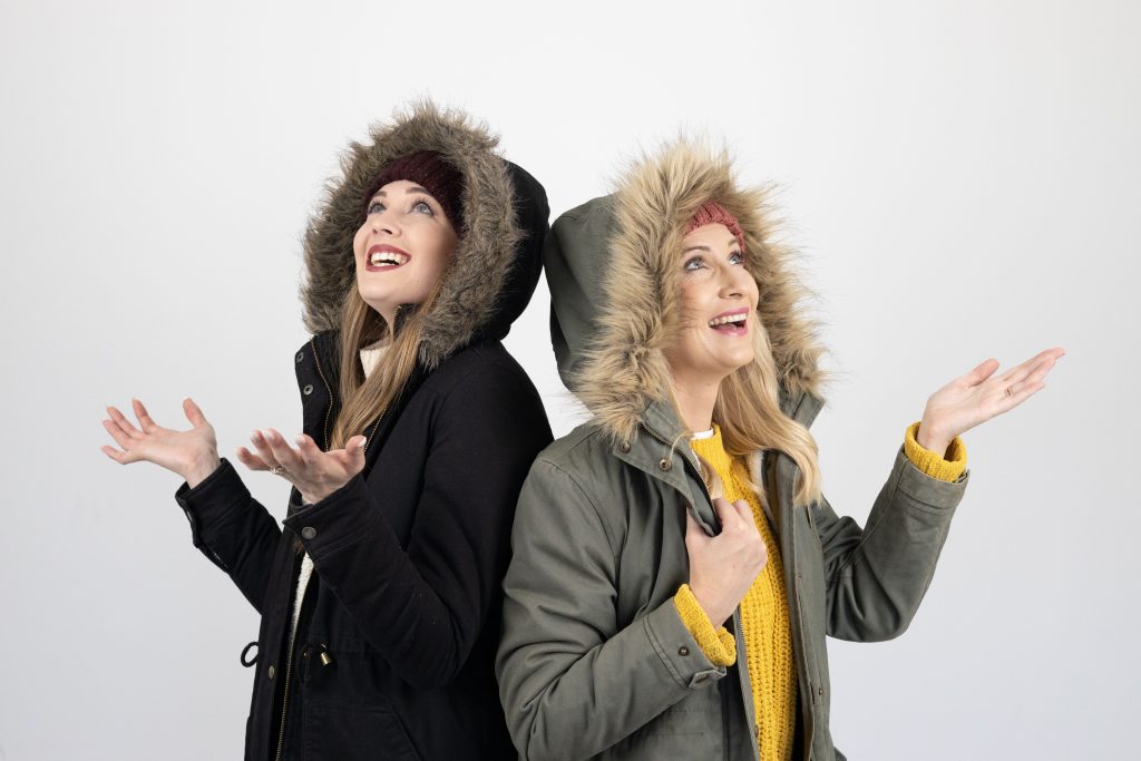
Vox Weather Meteorologist Annette Botha gives us the details on the 2025 / 2026 summer season – looking back on some of the drama that the weather has recently thrown at us, and what we can expect going into next year.
You can also click here to see Annette presenting this information in a short video in Afrikaans, as part of the regular ‘Langtermyn Landbou-Weervoorspelling’ series, and experience some spectacular additional video footage of recent weather-related visuals that are highlighted here.
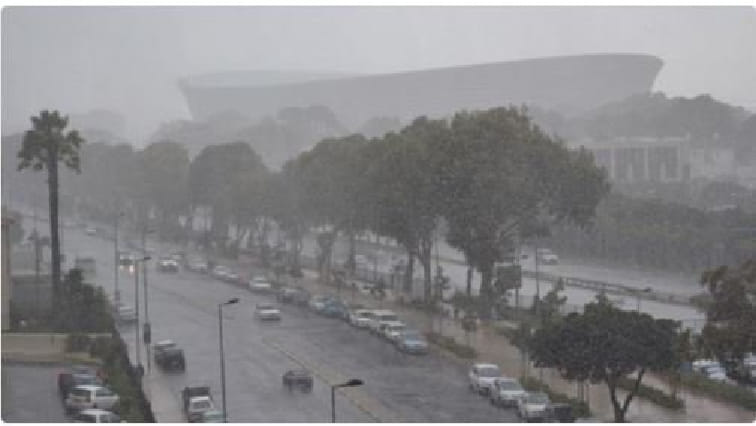
South Africans have just come through one of the most dramatic Novembers in recent years – it was a month marked by relentless thunderstorms in the north and east, with widespread hail, local flooding, and strong winds in the Western Cape.
Now, as we turn the corner into December, the latest seasonal forecasts point to a summer of strong contrasts: wet, stormy and cooler in the east, but hot, windy and fire-prone in the west.
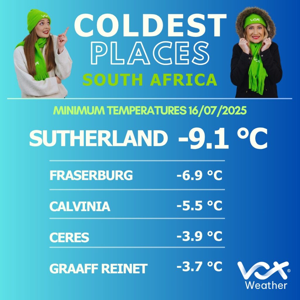
A Record-Breaking End to Spring
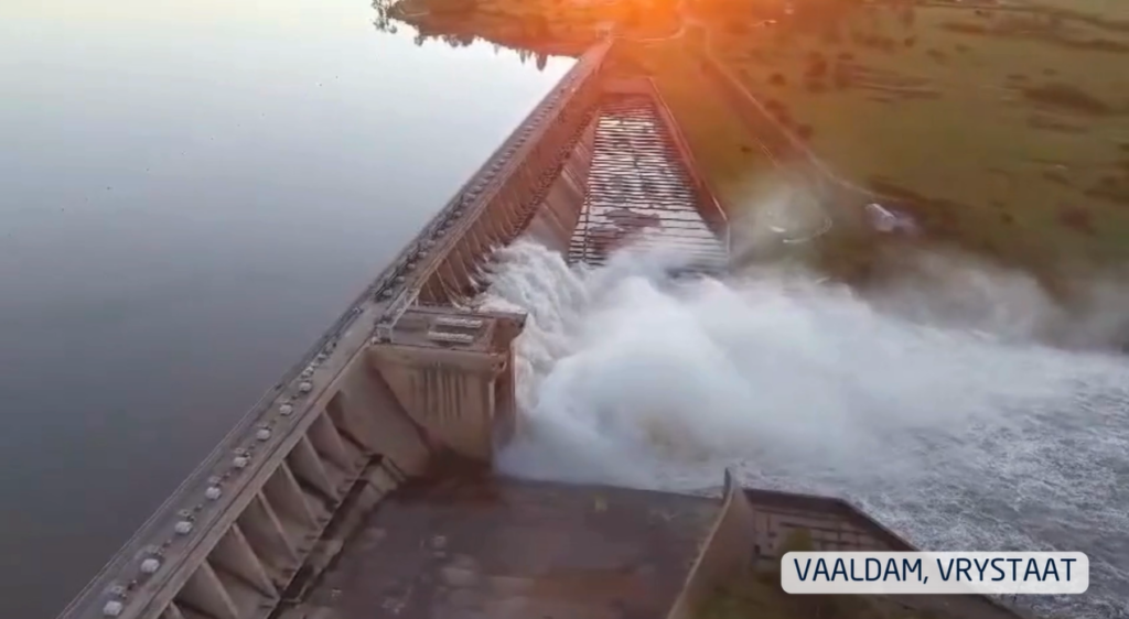
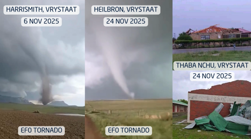
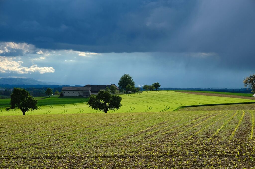
November delivered an onslaught of thunderstorms across Gauteng, Limpopo, North West, the Free State and the drought-stricken Eastern Cape. Many large dams responded quickly: the Vaal, Gariep and Bloemhof Dams rose sharply, with several spilling over.
Thunderstorms were fuelled by unstable, moisture-rich tropical air that repeatedly surged across the interior. More than one EF0 tornado was reported in parts of the Free State, a reminder that South Africa’s ‘tornado corridor’ can produce short-lived but destructive events almost every summer.
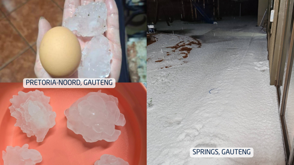
Hail was another standout feature of the month. In some towns, small hail accumulated so thickly that streets resembled winter scenes, trapping cars and residents. In other areas, hail the size of chicken eggs caused extensive damage to vehicles, roofs, gardens and crops. Farmers across the Free State and neighbouring regions faced the difficult balance of ‘good rain, but big losses’.
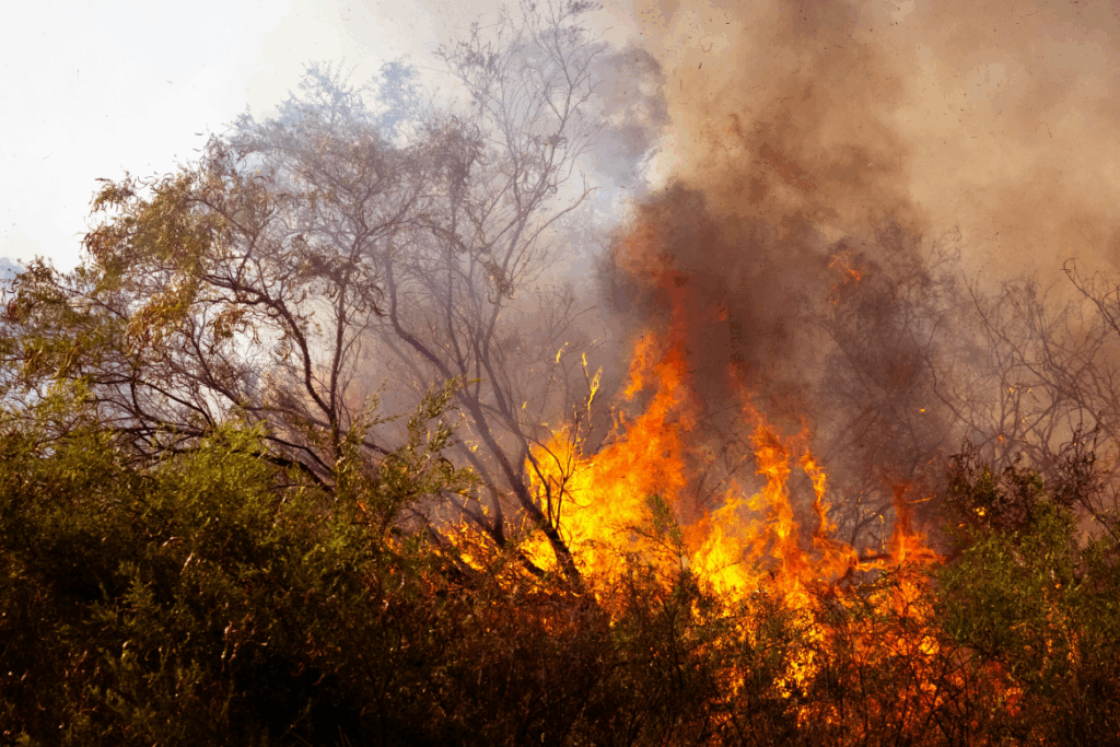
Meanwhile, in dramatic contrast, the Western Cape battled powerful southeasterly winds, fanning multiple wildfires across the Cape metro and agricultural zones. Homes were evacuated and producers faced early-season challenges with wind damage, low soil moisture, and fire risk.
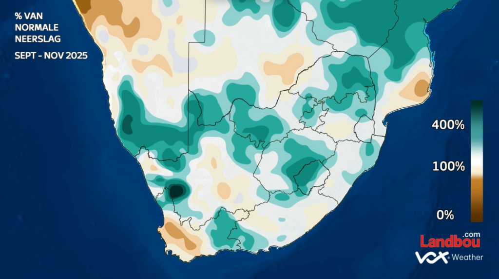
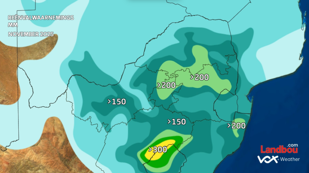
How Much Rain Actually Fell?
November did not just feel wet, it was exceptional. Large areas of the summer rainfall region recorded more than 150mm for the month, with pockets exceeding 200mm. To put this into perspective: Pretoria’s long-term November average is around 90 mm. Many regions received more than double their normal rainfall.
While the interior soaked, the Karoo, Eastern Cape and Western Cape experienced a notably drier spring, aligned with the persistent windier pattern that dominated the southwest.
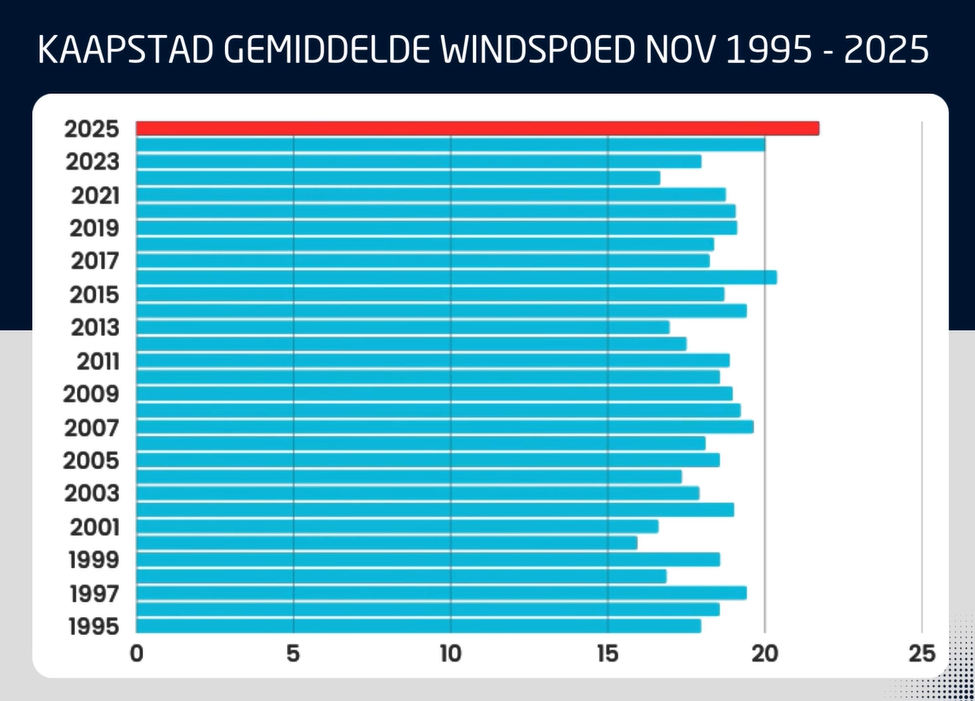
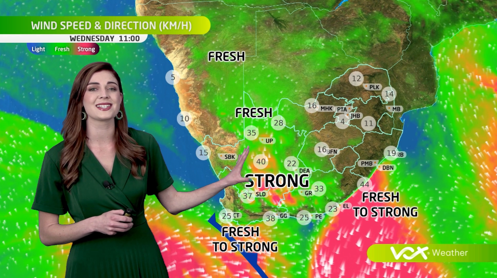
December Wind Outlook: More Gusts on the Way
November 2025 was confirmed as the windiest November since 1995 over the Western Cape based on 30-year wind-speed averages.
Unfortunately for Capetonians, the models show continued above-normal windiness in December.
This raises wildfire danger even further heading into the heart of the festive season.
Dams, Climate Drivers and What is Shaping the Season
Dam levels remain high across the interior and are expected to climb further with continued rainfall. In contrast, dams in the Western and Southern Cape are dropping quickly, with some municipalities already preparing for potential water restrictions.
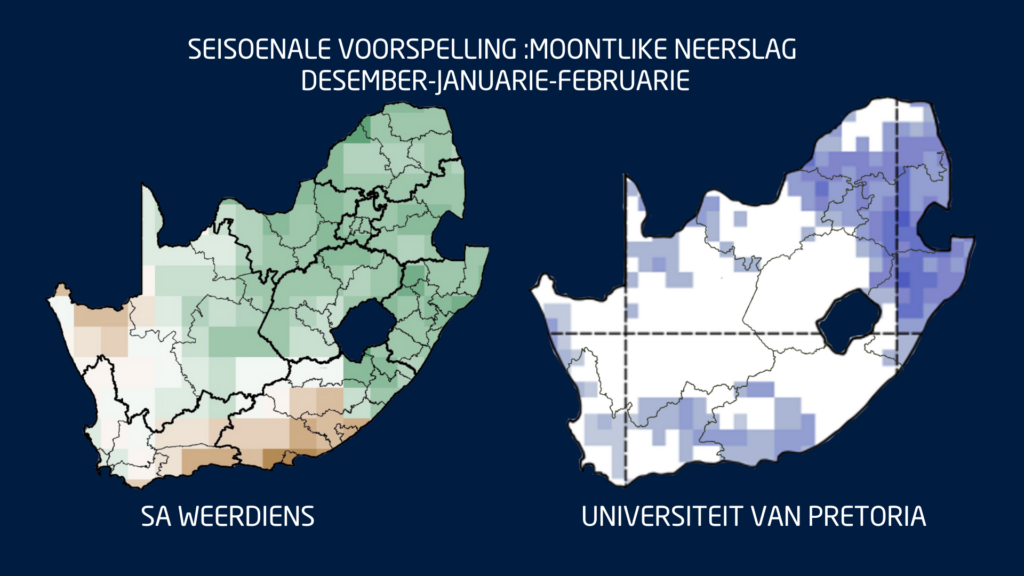
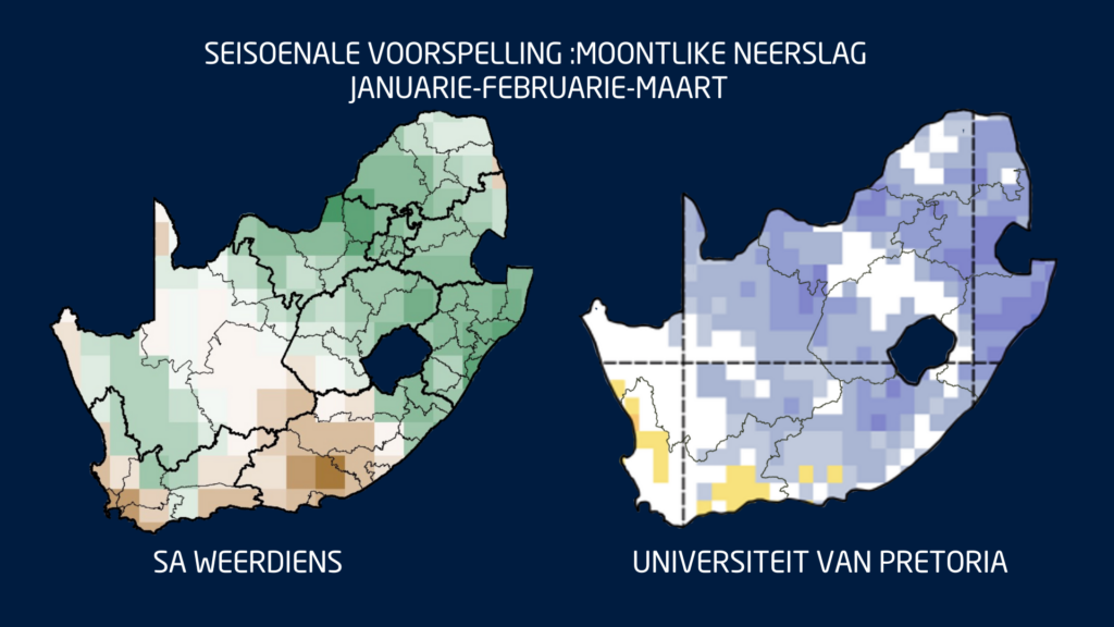
Globally, the climate system is reinforcing the wet-summer signal. We remain in La Niña conditions, and the Indian Ocean Dipole (IOD) is in a negative phase, a combination that historically supports above-normal summer rainfall for South Africa’s summer rainfall belt.
This means that December through February (DJF) still shows strong model agreement: a wetter-than-normal summer across the central and eastern parts of South Africa.
The only region where uncertainty remains is the Eastern Cape, ironically one of the provinces most in need of sustained rain. Seasonal guidance for January to March (JFM) keeps the same pattern: above-normal rainfall inland, with drier-than-normal tendencies persisting over parts of the Southern Cape.
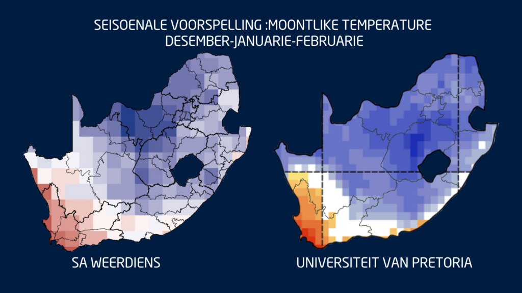
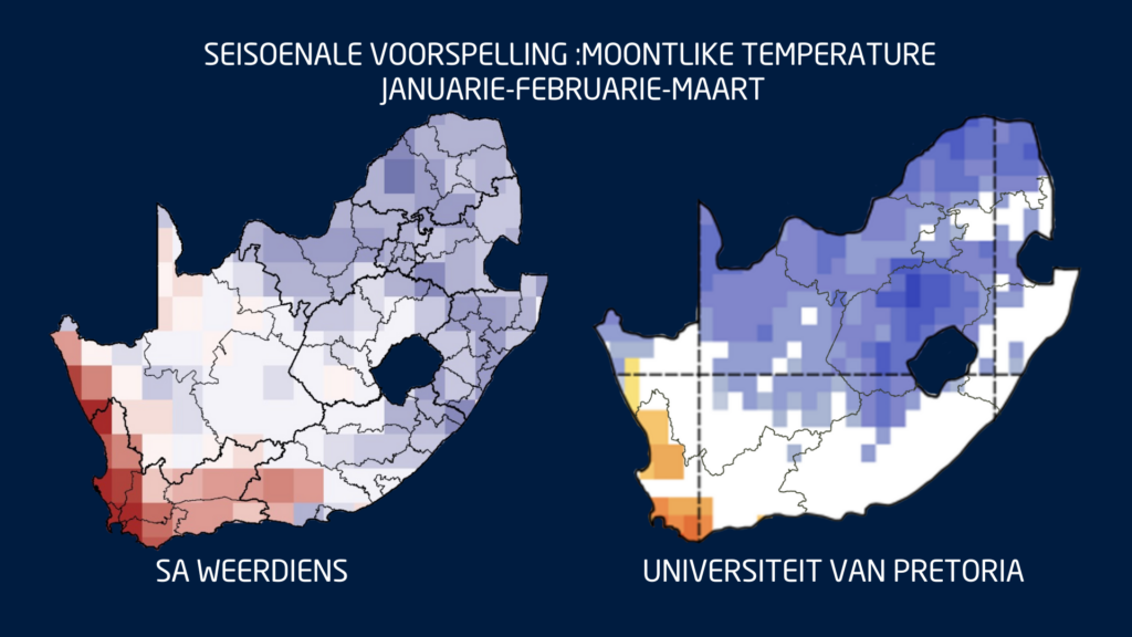
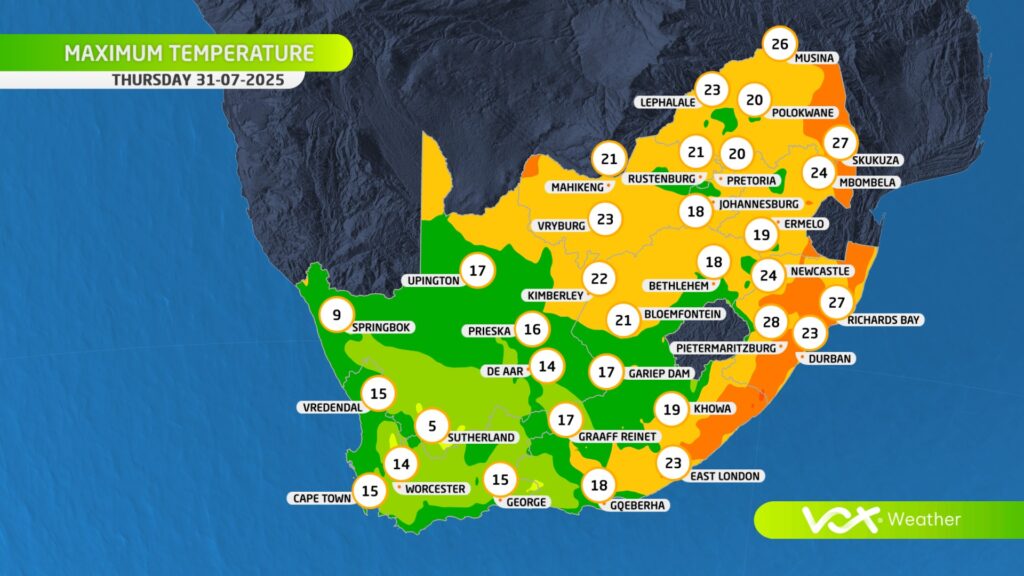
Temperatures: Cool in the East, Very Hot in the West
Where rainfall increases, maximum temperatures are expected to trend lower. Much of the summer rainfall region may see cooler-than-normal daytime temperatures through summer and early autumn.
However, the Western Cape, Northern Cape and Namakwa can expect very hot, windy conditions, especially toward the end of summer and into early autumn, a period when fire danger typically peaks.
What to Expect Week to Week
Short-term and sub seasonal models show a continued pattern of:
Farmers, disaster managers and residents should prepare for a summer with sharp contrasts: regular storms and good rain inland, and ongoing heat and fire risk in the west.
And finally a quick note to close off the year:
The Vox Weather ladies will be on annual leave for the festive season, but Vox Weather followers will still receive the daily weather maps throughout the period.
And so from Annette and Michelle: Wishing you a wonderful holiday period – travel safely and know that Vox Weather is always here to help you with your planning and continue ‘putting the WE back into Weather’!
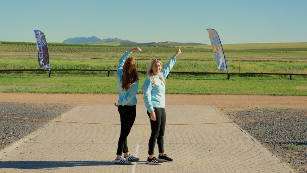
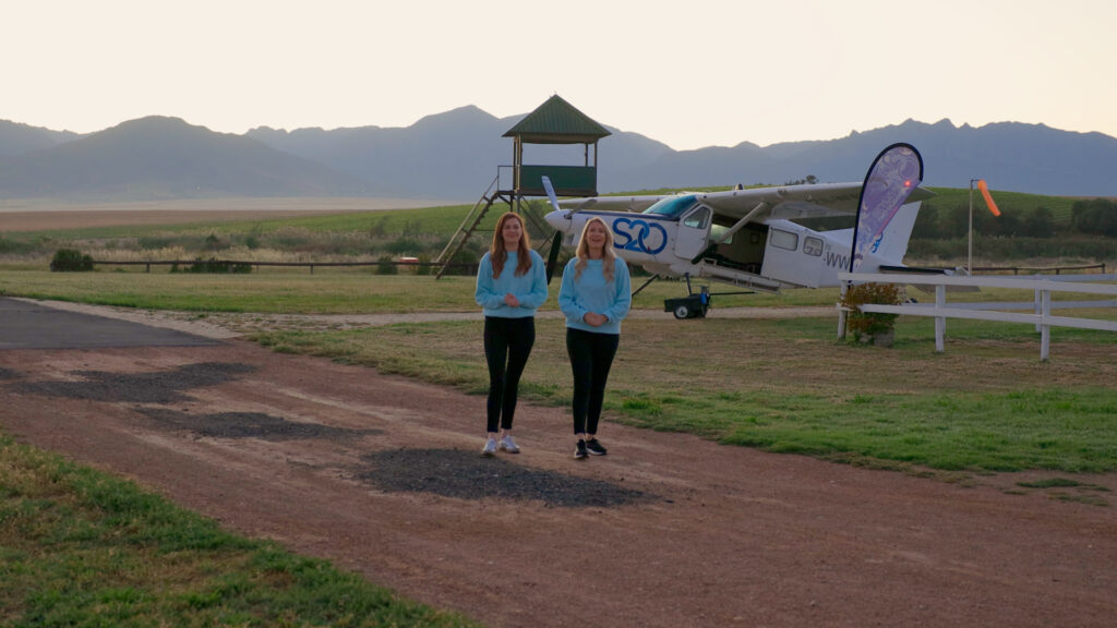
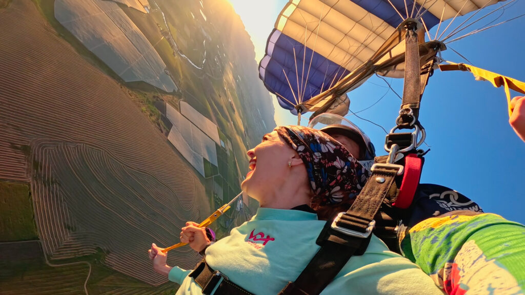
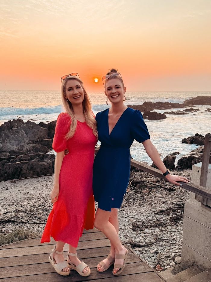
Vox Weather Meteorologists Annette Botha and Michelle Cordier decided to try out skydiving for themselves in the ongoing quest to go ‘beyond the forecast’.
We’re used to thinking of the weather as being something that shapes our everyday lives: going to and from work or the shops; checking in with friends and family; going to the mall; planning social get-togethers; playing sport; worrying about home and garden maintenance… the list goes on. Whether we’re experiencing sunshine, wind, rain or even snow, the weather plays a big role in the planning of our daily lives.
But what about those brave (or quite mad?) people who worry about the weather simply because they’re planning to fling themselves out of a perfectly good aeroplane at the weekend – in other words, skydivers?
You might remember Annette and Michelle’s previous adventure in the air when they went paragliding. Although both of these aerial sports involve parachutes, skydiving is a very different experience to paragliding – as we’re about to find out.
And so we look at some of the factors that determine when you can take a plane ride up into the sky before choosing to fling yourself back out of it, and when it might be best to stay on the ground, no matter how experienced a skydiver you might be.
Once again, Annette and Michelle bring us an idea in real life of how weather plays a critical role in shaping a unique aerial sport.
The Adrenaline Junkie’s Choice
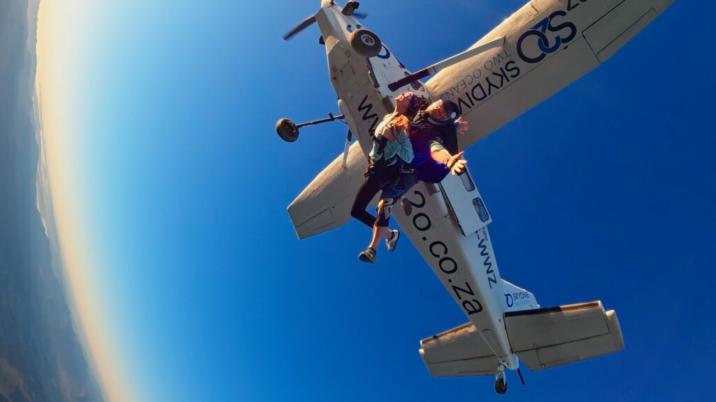
The adventure begins when skydivers take a plane ride up to a specified altitude before jumping from the aircraft and freefalling through the air, before deploying a parachute to slow their descent and land safely back at the ‘drop zone’.
You could say that with skydiving, the freefall is the main point of the experience, while the time when the parachute has been deployed – although enjoyable – is less important overall. Skydiving is definitely an ‘adrenaline junkie’ experience!
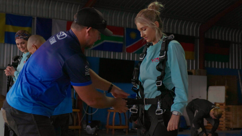
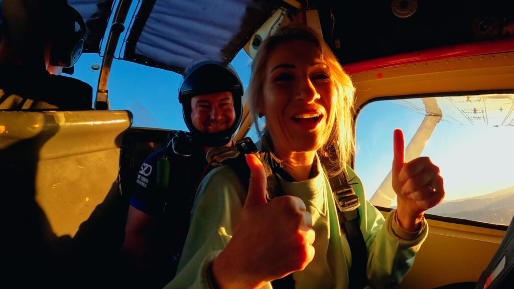
Many first-time or novice jumpers experience skydiving in a ‘tandem jump’, with a professional instructor who handles the technical aspects – which is exactly what Annette and Michelle opted to do.
But more on their actual jump experience shortly – first, let’s take a look at the role that the weather plays in this aerial sport that isn’t geared for the faint-hearted!
Skydiving and the Weather
Annette outlines: “We went skydiving with Blake MacMillan, owner, operator and chief instructor of Skydive Two Oceans, to experience first-hand and in real life how weather conditions shape every jump. It was truly the thrill of a lifetime!”
Certain weather conditions can significantly affect skydiving, and extreme weather can mean that a planned jump might need to be rescheduled. Skydiving is best when there are blue skies, light winds and moderate temperatures. Clouds, rain, wind and extremely low or high temperatures can all be reasons for skydiving to be placed on hold, or cancelled outright.
The weather is monitored constantly, and those in charge are continuously considering on-ground wind speed and observing what they can see. This includes checking what the clouds look like, and how parachutes are handling the wind as the skydivers soar above ground, and when they come in for landing.
Blake explains: “Before every skydiving day at Skydive Two Oceans, a ‘weather group’ comprised of the more senior pilots and sky divers will look at weather forecasts and consider whether they think the weather will be conducive to jumping the next day. We also take into consideration the experience level of the jumpers. On the actual morning, we then look again at what the weather is doing and make our decisions accordingly.”
Annette adds: “The senior skydivers write down the wind speed and direction, from the ground all the way up to the drop altitude, and on the day we went skydiving, the winds were light to moderate, except for a fresh breeze between 2,000 and 3,000 feet, with the wind mainly coming out of an easterly to north-easterly direction.
“And so, taking all this into consideration, the senior skydivers used a formula to calculate that the plane had to fly in an easterly direction against the wind, with the first jumper opening up their parachute approximately 0.1 nautical mile before the drop zone, so that the rest of the jumpers could open up their parachutes between 0.2 and 0.6 nautical miles after the drop zone, allowing everyone to fly back home safely.”

The wind’s direction and strength are important factors when determining the safety of the jump. A gentle breeze or moderate winds don’t present a challenge, but strong winds can be hazardous, leading to unsafe landing conditions. A speed of 25 knots is considered to be the maximum wind speed for safe skydiving, and any winds exceeding this limit are reason to reschedule the jump to a day with better wind conditions.
Wind gusts – meaning sudden, brief increases in wind speed that typically last less than 20 seconds – are also potentially hazardous for skydivers because they can cause sudden, unpredictable changes in speed and direction, making landings more difficult and potentially dangerous. Gusty conditions can also push skydivers off course, causing them to drift into dangerous areas like trees or power lines.
Rain also plays a factor in deciding whether to jump or not – the visibility is lowered, and skydiving gear wasn’t designed to be used in the rain. In addition, raindrops hitting your face at 200 km/h is not a pleasant experience! And so, when there is a high probability of heavy rain, the skydiving will probably be rescheduled. On days with patchy clouds and showers, the weather decisionmakers might wait for the weather to clear before proceeding with the jump.
Clouds can also play a role, because a very low cloud covering the entire landing area may pose a serious risk. In such conditions, it becomes difficult to see the landing site, and the reduced visibility makes it challenging to manoeuvre the descent safely.

Tandem Jumping with SkyDive Two Oceans
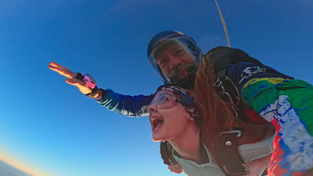
Tandem skydiving involves a certified instructor and a student, rather than the student flying solo. During the tandem skydive, both the instructor and the student jump out of an aircraft together, strapped to each other during the entire descent and sharing a single large parachute. The connecting straps are designed so that the student is in front and the instructor behind, and during the jump, the instructor is floating above the student during the freefall.
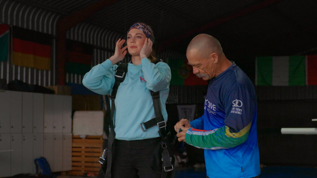
The tandem instructor is responsible for keeping both people in a stable position during the skydive, before deploying the parachute at the right time (and height) and then facilitating a safe landing. Because the instructor does most of the work, the student’s responsibilities are largely limited to watching an orientation video and then going through a briefing with the instructor before getting geared up. All of this can be done right before the skydive, so not a lot of training is necessary.
Those students who particularly enjoy the experience might find that afterwards, they want to take skydiving further and learn to fly solo – but that’s a whole other story!
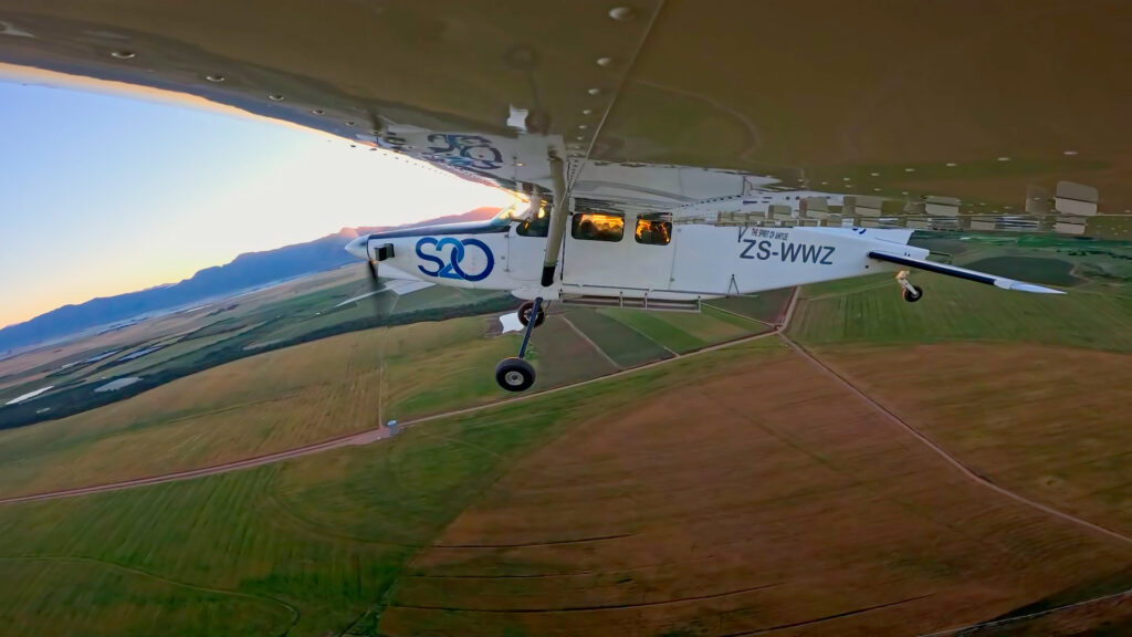
Skydive Two Oceans is situated in the heart of the Cape Winelands, close to the scenic farmlands of Wellington, and less than an hour’s drive from Cape Town’s CBD. As the plane climbs to altitude, the skydivers can see incredible views of the surrounding Winelands, the beautiful Table Mountain, and two sparkling blue oceans.
Blake, who is also primarily responsible for safety and training within his company, says: “I’ve been skydiving for around 25 years now, doing it as a full-time business for just over 18 years and running SkyDive Two Oceans for just on seven years. As well as the thrill of skydiving itself, I got hooked on sky diving partly because of the close-knit community of people, while the venue itself here in the Western Cape is one that is surrounded by beauty!”
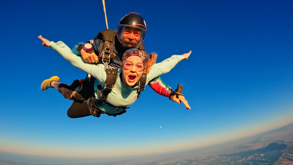
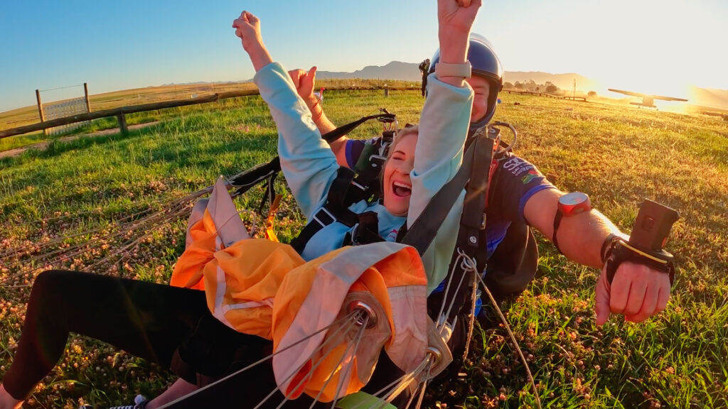
After a plane ride of about 25 minutes, Annette and Michelle’s skydiving experience saw them freefalling from an altitude of about 14,000 feet (4.27 kilometres), at a speed of over 190 km per hour!
The freefall period lasted between 30 and 35 seconds, with the follow-up parachute ride to descend safely back down to earth lasting about five minutes.
You can watch Annette and Michelle climbing out of the plane strapped to their respective instructors from about 6:50 minutes into the video, with Annette going first – and after that, the rest is now history!

Freedom Calling!
Blake says that skydiving, for him, represents freedom, but he does acknowledge the fear factor, adding: “When you’re sitting on the edge of the plane about to jump out, you will be questioning some of your life decisions leading up to that point!
“But the anticipation is the worst part when it comes to managing your fear – once you’re actually out of the aircraft and in freefall, the fear tends to go away and you just enjoy the experience and start to have fun, especially when you’re doing it with a trained professional.
“The more you do it, the better it becomes, and so we always encourage people to try it out more than once in their lifetimes. After the first time, your brain has now processed matters somewhat and it feels more familiar and becomes easier.”

Certainly the video shows Annette and Michelle looking nervous to a greater or lesser degree at various moments before and during the plane ride! But having overcome their nerves, there are no regrets.
“We once again took forecasting to new heights,” says Annette, “and it was awesome! In our opinion, it felt less like falling and more like flying! This is where weather meets wonder…”
“Yes,” agrees Michelle, “it was an adrenaline rush and a moment of freedom that we wish everyone could experience at least once in their lives! Huge thanks to Skydive Two Oceans for taking us on the ride of a lifetime!”

“Once you have tasted flight, you will forever walk the earth with your eyes turned skyward, for there you have been, and there you will always long to return.” ~ from the 1965 film: ‘I, Leonardo da Vinci’
We chat to Michelle du Plessis, our very own Vox Weather meteorologist, and find out more about what she loves both in and outside work.
Michelle regards meteorology as being a balance and blend of science and storytelling. And certainly it’s come a long way, from ancient civilisations observing celestial patterns or monitoring the movements of birds and animals, to the modern-day usage of advanced technology and complicated maths.
Michelle – who is one half of the acclaimed Vox Weather duo, together with colleague and mentor Annette Botha – shares details about her daily working life, as well as some of her challenges and aspirations.
We also find out more on how hard she has worked to follow her dream.
Inspiration During High School
Michelle’s future career as a meteorologist began in high school, where she loved Geography and was also good at Maths. She explains: “My Geography teacher, Mrs Esther Fourie, was simply amazing and truly inspirational. I became interested in pursuing Geography at the tertiary education level, but I wasn’t too sure initially of what was available to me in the field.”
Here she smiles: “I wasn’t that keen on looking at rocks, for instance! But I really liked the weather component of Geography. So I did some research and decided to study meteorology. Once at university, I found the course to be very scientific and also mathematical, and in fact more challenging than I’d expected, but always very enjoyable.”
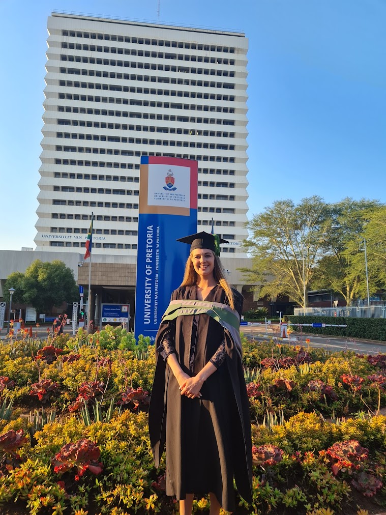
Michelle studied for a BSc Meteorology at the University of Pretoria, which is currently the only university in South Africa to offer the course, and she then went on to complete her Honours degree, graduating Cum Laude and at the top of her class. It wasn’t always plain sailing though: financial and COVID-linked challenges were looming.
Grit and Determination
Having been granted a bursary during her undergraduate years, Michelle had to start paying for her studies in full during her final Honours year. “It was financially challenging,” she says, “but I managed to get through by juggling a couple of jobs while I was still studying. I found different work for myself, doing a bookkeeping job as well as some tutoring work. Fortunately, I do like both Maths AND children – if I hadn’t become a meteorologist I could easily have become a teacher!”
Another significant challenge came about because of the COVID-19 pandemic. Michelle explains: “I was doing my Honours degree during the COVID period, and it ultimately had a very negative impact on job opportunities in the broader meteorology arena. This was largely because most graduate meteorologists would traditionally be absorbed by the South African Weather Service (SAWS) after they had finished their studies.
“However, one of the main incomes for SAWS is the production of forecasts relating to the aviation industry, and obviously COVID caused global flights to be cut back severely. The end result was that, in the year after I’d finished my Honours degree, SAWS wasn’t able to hire in any of the meteorology graduates from my year, which was a serious blow for all of us at the time.”
However, Michelle is both determined and resourceful, and so to support herself, she continued with her previous bookkeeping and tutoring jobs for about another year or so – something which, she says, taught her continued resilience and perseverance, even while her dream job wasn’t immediately within reach.

“I definitely had some tough moments along the way,” she admits, “but I also learned that hard work and staying positive can eventually pay off. I don’t like dwelling too much on the past – I believe that everyone faces their own challenges.”
Her chance to finally work in her chosen field came when she was able to join Annette at Vox Weather from February 2023 as a Junior Meteorologist.
“It’s really fulfilling to be working today in the field that I studied for,” she says. “I’m so grateful for the opportunity to be working now as a meteorologist and gaining exposure to a truly interesting and satisfying working life.”
It’s also clear that her formative challenges have helped to shape her impressive work ethic.
A Day in the Life…
So what does a day in the life of a meteorologist look like?
Michelle says a typical week involves analysing weather models and trends, preparing the daily forecasts, and switching into content creation and filming to produce material across different platforms, from short TikTok clips to the main daily show that goes live at 18:00. In short, forecasting requires scientific modelling work, after which content must be created for different audiences and formats.
She explains: “Basically I forecast and present the weather, but that’s not all. We also do quite a lot of interviews with newspapers and radio stations. Then besides that, we additionally plan field trips, including for our ‘Beyond the Forecast’ episodes, where we go a bit deeper into how weather can impact on other experiences. So it’s a lot of science, and then quite a bit of fun as well!”

Her field work is an important and much‑loved part of the job, including snow chases, Namaqualand flower shoots, and even hot‑air balloon and paragliding experiences – all in the name of finding out more about the local weather and its effects.
Says Michelle: “So much of my field work has already become what you could call ‘bucket list’ types of experiences. Having grown up in Pretoria and then relocated to the Western Cape for Vox Weather, I hadn’t previously experienced snow until we went snow chasing for work last year, which was amazing and today is one of my favourite memories!”
And staying with the idea of ‘snow angels’, Michelle adds that she “likes to think of the Vox Weather meteorologists as being South Africa’s Weather Fairies…!”
It’s a fun thought, because fairies traditionally help to make good things happen, and Michelle and Annette together do just that, using modern technology for both the initial weather forecasting as well as sharing their information and analyses via the Internet.
When discussing the audience differences across various social media platforms, Michelle notes that TikTok attracts a younger audience, while Facebook often brings older and more seasoned followers.
“Geographically, Vox Weather’s biggest engagement comes from the major urban centres, including Gauteng, Cape Town, Durban, Port Elizabeth and Bloemfontein,” she outlines, “while the audience engagement can also vary by season and region. For example, people in Gauteng often react strongly to cold snaps and hail, while Western Cape viewers are more used to rain and winter patterns. In general though, it’s safe to say that engagement tends to spike during extreme or unusual weather events. Our Vox Weather community is overwhelmingly positive and appreciative, with only the odd negative comment that we don’t dwell on.”
Challenges and Resilience
Being in the public eye can be challenging,” Michelle confirms, “and there are obviously times when we get negative comments – we do sometimes get the forecast wrong! People can be quite harsh on us if we predicted rain that then didn’t happen, for example. My response then is to ask people to remember that the atmosphere overall is quite complex, and that a small change can make a big difference. We always say: ‘It’s just the forecast – it’s not a promise!”
She notes that another hallenge includes presenting in English, which isn’t her home language (Michelle comes from an Afrikaans upbringing originally), but she continues working on her linguistic skills.
To counteract these occasional work challenges, Michelle is grateful that the team at Vox Weather is friendly and supportive, with Annette being a kind and flexible mentor: “I’ve been allowed to work with a significant amount of creative and professional freedom while developing my own presentation style, wardrobe choices and the planning of shoots,” she says.
“I also have tremendous support from my husband, Renaldo, and I’m really enjoying married life – I’m finding it an absolute joy. I’m so lucky to be married to someone who supports me wholeheartedly – he’s my calm in the chaos! While I do miss some key family members and friends, moving to Cape Town together has opened up a meaningful new chapter for us.”
Into the future, Michelle would like to continue with her academic studies at some point by doing a master’s degree, possibly with a focus on changes to rainfall patterns under a warming climate. She’s also interested in growing further within Vox Weather and having her own future role in mentoring other meteorologists going forward.
“I’m very proud to be part of Vox Weather,” says Michelle. “We’ve built a brand that people trust, and we’ve worked really hard to get there. I also love the fact that every day is different, whether we’re forecasting and standing in front of the camera, or out in the field.
“I’m very grateful for the job I have, and I love every day of it. And just know, when you see me on the screen having fun during a snow chase, that it probably took three weather models, two coffees and one very determined fellow meteorologist to get me there!” she concludes.
Did you ever notice how the increased winds in August in South Africa’s interior are closely linked to the seasonal transition from winter to spring?
Vox Weather Meteorologist Michelle du Plessis tells us more.
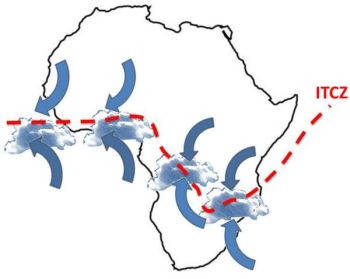
During winter, much of South Africa is dominated by a stable high-pressure system over the interior. By late winter, this high-pressure system begins shifting as the Intertropical Convergence Zone (ITCZ) also moves further south, while cold fronts from the southwest continue to pass across the country.
The interaction between these different air masses, namely colder, denser air from the west and warmer, lighter air building over the interior, creates a tighter pressure gradient. A tighter pressure gradient causes air to move faster, which is experienced as stronger winds.
At this time of year, vegetation and soils are generally at their driest after months of limited rainfall. This allows dust and sand to be lifted more easily by the wind, and also creates ideal fuel for fires. The combination of dry vegetation, low humidity and strong winds makes it far easier for flames to spread rapidly and become uncontrollable.
These conditions are a key reason why August is one of the worst times for any open burning, as even a small spark can quickly escalate into a runaway wildfire.
When Will the Rains Come?
The ‘August winds’ is generally a late‑winter feature that usually builds from late July, peaks through August, and fades during early to mid‑September. Mechanistically, the windiness is driven because of strengthening pressure gradients between lingering cold fronts to the southwest and a warming interior.
In most years, the interior’s first spring showers arrive mid to late September, but they’re usually light and isolated. The true start of the rainy season, with consistent, useful rainfall, tends to occur from October into early November.
Recent research confirms a shift toward a later onset of rain, especially in Gauteng and surrounding areas. What was once expected in September now often only establishes in October or even November.
This trend is linked to climate change and ENSO cycles, with El Niño years delaying rain and La Niña favouring earlier onset.
The bottom line is that the spring rains are coming, but they’re running later than they used to.

As the frontal influence relax and low‑level moisture flux from the northeast strengthens, winds generally ease from their late‑winter peaks and thunderstorm days begin to appear.
A practical rule of thumb is a one to four week overlap or transition: the gusty late‑winter pattern tapers off in early to mid-September; the first weak convective events pop up mid‑ to late September; and finally more reliable rainfall usually arrives in October.
Are We Seeing a Change in the Beginning of the Seasonal Spring Rains?
The short answer – in Michelle’s opinion – is yes.
She believes that there has been a change in the beginning of the seasonal spring rains in South Africa in recent times.
It matters because:
The Role and Effects of Fire
In the Western Cape, fire is essential for fynbos regeneration. In the interior grasslands and savannas, fire also plays an important ecological role, but timing and intensity matter.
Well-timed, cooler burns (usually done controlled, under calm, moist conditions) help remove old grass, stimulate new growth, and control bush encroachment.
However, August fires driven by strong winds are often too hot and fast, making them more destructive than beneficial. These fires can damage soil, kill recovering vegetation, and destroy grazing land.
So while fire is natural and even necessary in some ecosystems, the August fire season in the interior is more risky than helpful, especially when fires are uncontrolled and fuelled by dry, windy weather.
What Does This Mean on the Ground?
Farmers, planners and residents relying on spring rains can no longer count on September showery starts. In practice, October is fast becoming the more dependable month for meaningful rainfall, especially across Gauteng and the interior.
The bottom line?
Yes, spring rains are shifting later in South Africa. Research confirms that it’s happening, and that climate changes are steering the trend.
El Niño and La Niña also play a role. El Niño years tend to bring later and weaker rains, while La Niña often brings earlier and wetter conditions. We are expecting a weak La Niña to develop by summer, which may result in above-normal rain in the summer over the summer rainfall regions.
This is a celestial event you won’t want to miss — and one of the best lunar eclipses visible from South Africa in years.
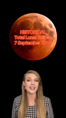
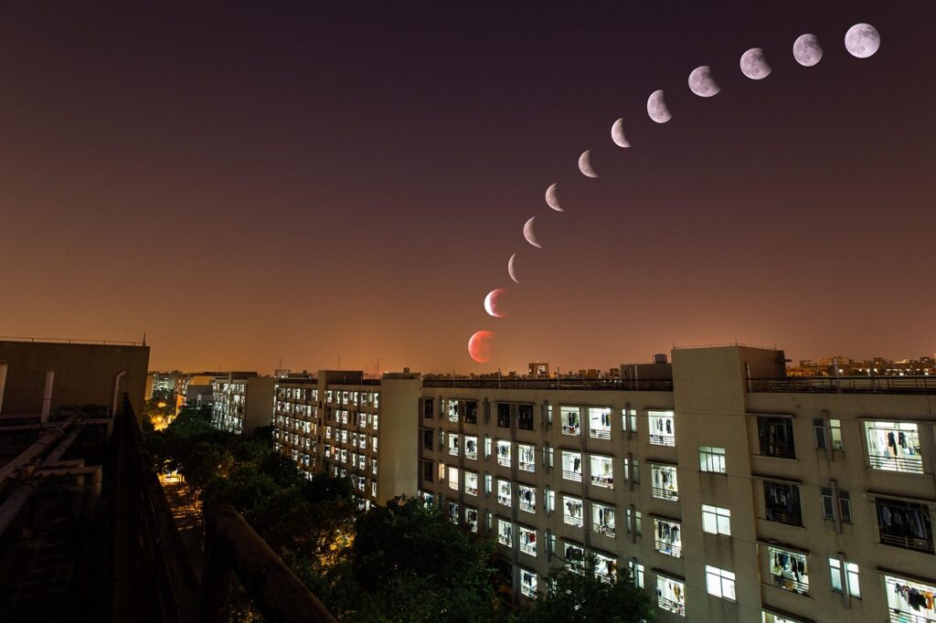
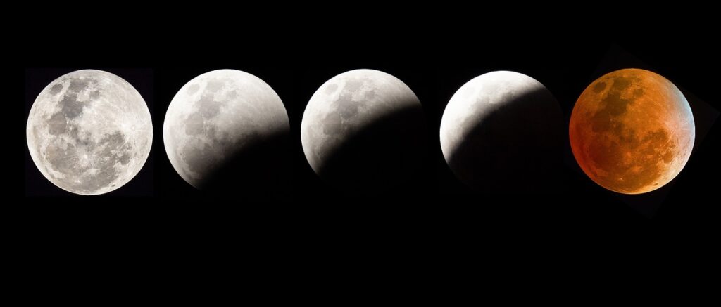
Stargazers around the country have been waiting impatiently for a stunning astronomical spectacle that’s taking place on the night of Sunday the 7th of September 2025, when a rare total lunar eclipse, commonly called a Blood Moon, will be visible across the country. Grab your warm jackets (it can still be cold during September evenings) and get comfortable as the sky puts on an amazing show!
Vox Weather Meteorologist Michelle du Plessis tells us more about how lunar eclipses are formed, and the weather we can hope for on Sunday night.
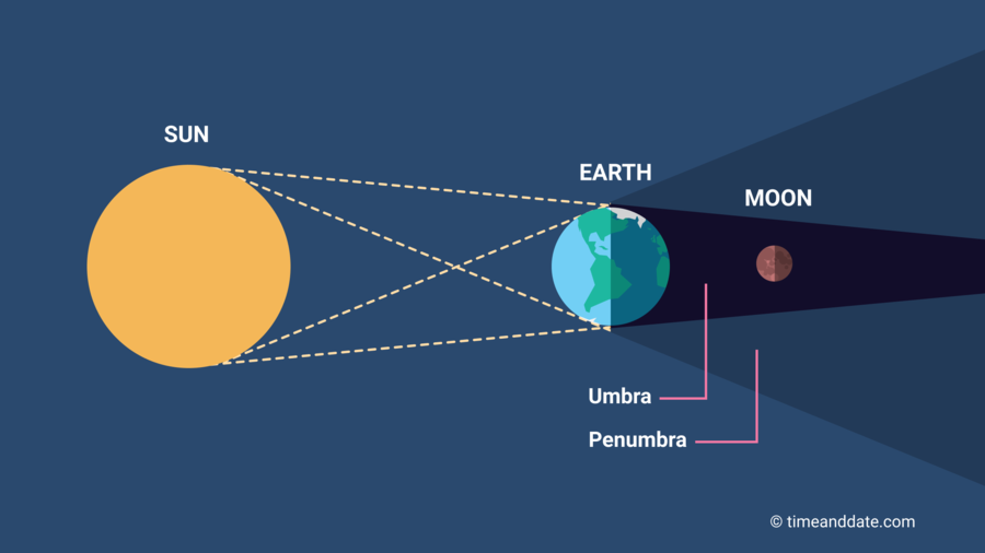
What is a Lunar Eclipse?
A lunar eclipse happens when the Earth passes directly between the Sun and the Moon, casting its shadow onto the Moon. This only occurs during a full moon.
There are three types of lunar eclipses:
During a total lunar eclipse, the Earth blocks direct sunlight from reaching the Moon. However, sunlight still filters through Earth’s atmosphere and bends (or refracts) around the planet.
Shorter blue wavelengths are scattered, and the longer red and orange wavelengths reach the Moon — causing it to glow red or copper.
It’s the same effect that gives us red sunrises and sunsets — except this time, you’re seeing it reflected back from the Moon!
This TikTok video from Michelle shows us more on how lunar eclipses take place – together with a quick weather overview for the country’s stargazing.
The 7 September 2025 eclipse is special because:
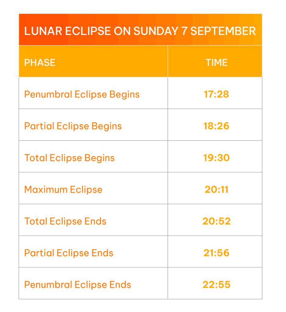
South Africa Viewing Details and Weather Conditions
The table shows the key moments to look out for. The best time to watch is between 7:30 PM and 8:52 PM, when the Moon will be completely within Earth’s shadow and glowing red.
The weather conditions for 7 September across the country will be mostly favourable for viewing the total lunar eclipse on Sunday evening.
For the best view, try to find an open area away from city lights — ideally elevated, with an unobstructed view of the eastern horizon where the Moon will rise.
Tips for Watching and Photographing
Fun Facts
Why Is It Called a “Blood Moon”?
The term ‘Blood Moon’ comes from the deep red colour the Moon takes on during totality. Ancient cultures often saw it as an omen, but today we know it’s simply the effect of Earth’s atmosphere bending sunlight.
Mark your calendars and if skies are clear, look up and enjoy the show!
South Africa is one of the few countries in southern Africa that regularly has snow – in places – in winter.
Vox Weather Meteorologist Michelle du Plessis tells us more.
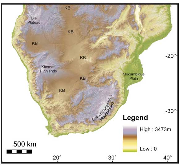
South Africa’s climatic diversity is largely due to its geographic position at the southernmost tip of Africa, where it’s influenced by both the warm Agulhas Current on the east coast and the cold Benguela Current on the west coast. Its varied topography – ranging from high plateaus to mountain ranges like the Drakensberg – creates conditions cold enough for snowfall in winter. Being the furthest south on the continent, South Africa is also directly affected by mid-latitude cyclones and cut-off low-pressure systems. When looking at our neighbouring countries, clear contrasts emerge in winter weather patterns.
(Image left courtesy Mantle Plumes; Image right courtesy Vox Weather)
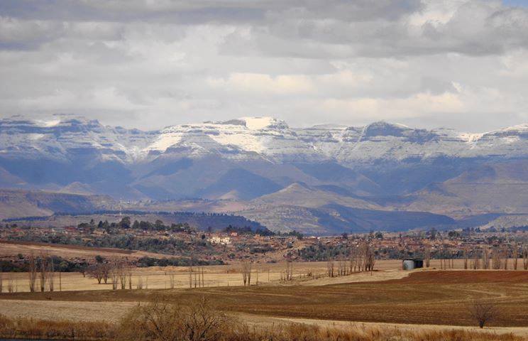
Lesotho, though an independent country, is entirely landlocked within South Africa.
Its high elevation – most of the country lies above 1,800 metres – means it experiences regular snowfall in winter, particularly over the Maloti Mountains, much like surrounding high-lying areas of South Africa.
(Photo courtesy Snow Report SA / Marietjie Hayward)
Namibia and Botswana experience dry, sunny winters with cool nights and warm days, but their generally low elevation and arid conditions make snowfall virtually impossible.
In Namibia, bergwinds or “oosweer” often bring warm, dry weather and occasional sandstorms as strong north-easterly winds prevail after the passage of cold fronts. Although rare, light snowfall can occur in the far south of Namibia when a particularly strong cold front moves unusually far north.
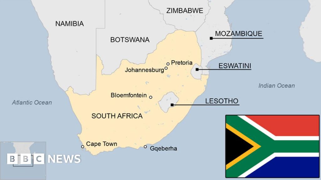
Zimbabwe and Mozambique have subtropical to tropical climates. Their winters are dry and mild, with average temperatures rarely dropping low enough to produce frost, let alone snow.
Eswatini experiences slightly cooler conditions in winter, especially in its highland areas, but snowfall is extremely rare due to its lower elevation and more humid climate.
(Map image courtesy of BBC News)
These regional differences highlight how South Africa’s southern location, combined with its topographical range and oceanic influences, makes it uniquely positioned to experience a wide variety of winter weather, including rain and snow – conditions seldom seen in its neighbouring countries.
(Click here to find out how snow weather occurs.)

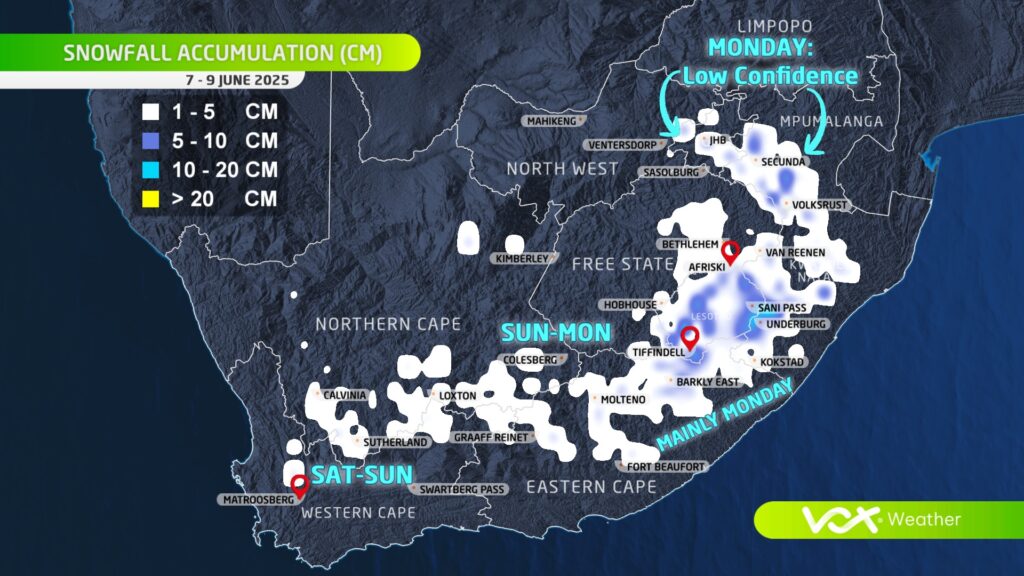
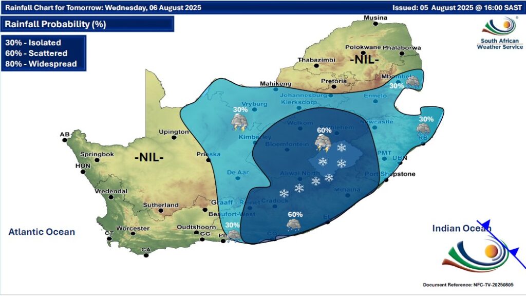
GARDEN ROUTE | KAROO NEWS – While snowfall is likely to evade Gauteng, a strong cut-off low will develop over the western part of the country on Wednesday and slowly move eastwards, spreading cold and wet weather over central and later eastern parts of South Africa.
According to Vox Weather, models are indicating a mix of rain, snow, and graupel is likely over central South Africa (parts of Free State, Northern Cape, Eastern Cape, Lesotho).
What is happening to SA’s winters and is climate change playing a significant role? Vox Meteorologist Michelle du Plessis tells us more.
Data shows that winter temperatures across southern Africa have been steadily rising since the 1960s, with fewer days of frost and freezing conditions.
According to the NOAA, extreme cold events are now far less common – and when they do happen, they’re generally milder than in the past.
In the Western Cape, where winter rainfall is vital, climate models show that the rainy season is becoming shorter and more variable.
While some winters still bring strong cold fronts and good rainfall, others are marked by long dry spells.
The WMO warns that drought risks are increasing, especially in Mediterranean-type climates like the south-western Cape.
Interestingly, while total rainfall may decrease, when storms do occur, they may be more intense – bringing short bursts of heavy rain rather than steady soaking periods. This is because warmer air holds more moisture, which can lead to more powerful frontal systems when they develop.
Recent studies suggest that mid-latitude frontal systems – the cold fronts that bring winter rain – may grow stronger under climate change. However, this doesn’t mean we’ll get more of them. Instead, we may see fewer, but more intense, winter storms, followed by longer dry periods in between.
What this means for South Africa
In short, South African winters are becoming:

Some early snow forecasts recently circulated on social media suggested possible snowfall over parts of Gauteng, North West, the Highveld, and other areas that rarely experience snow during late July. At Vox Weather, we chose not to post about these projections – and here’s why.
Advanced snow forecasts, particularly more than five days ahead, are often subject to significant change. In fact, updated model guidance today NO LONGER indicates snowfall over these north-eastern regions at all.
Our approach as meteorologists to snow forecasting involves more than just looking at model snowfall outputs.
We analyse:
These factors must all align for snowfall to be possible. A shift in any of them can lead to significant changes in where snow may fall – or if it occurs at all.
As of the latest forecast, we see:
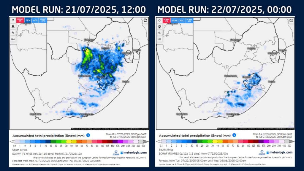

At Vox Weather, we prefer to wait until we see consistency in multiple forecast runs – usually within a five-day window – before communicating potential snowfall.
This ensures that our updates are as accurate and reliable as possible.

The arrival of snow isn’t an everyday occurrence for most of South Africa.
As we find ourselves back in snow season, we sat down with Vox Meteorologist Michelle du Plessis to give us the lowdown on how snow is formed.
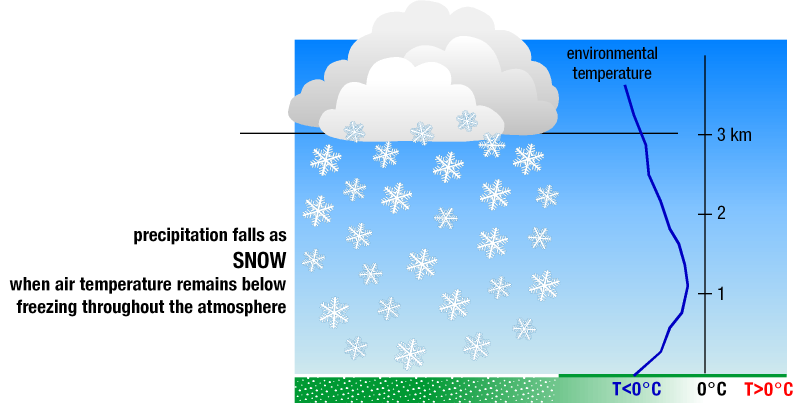
And it turns out that, for snow to fall and reach the ground, three main weather conditions must come together.
Cold air from top to bottom: The air must be below freezing (0 °C) all the way from the clouds to the ground. If there’s a warmer layer in between, the snow will melt and fall as rain or sleet. Ideal snow forms in clouds where temperatures are between -10 °C and -20 °C.
Enough moisture in the air: Cold air alone isn’t enough – you also need moisture so that water vapour can form ice crystals. Dry air, even if freezing, won’t produce snow.
Something to lift the air: Snow usually forms when air is forced to rise, cool, and condense. This can happen with cold fronts, low-pressure systems like cut-off lows, or when air is pushed up over mountains.

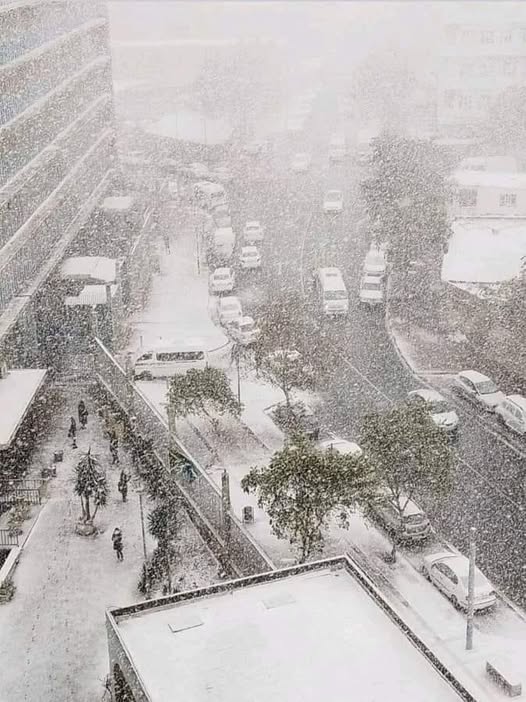
Gauteng’s last snowfall: July 2023…
In July 2023, Gauteng experienced rare snowfall – something locals hadn’t seen in over a decade (before 2023 it snowed in 2012 and 1996). While light snow sometimes falls in the province, heavier events like this happen only once every 10 to 20 years. So yes, it was unusual, but not unheard of.
The July 2023 cold snap wasn’t driven by climate change – instead, it was the result of a powerful cold front that swept across the entire country and extended into our neighbouring countries – supported by a steep upper-air trough, pushing icy air far north.
Looking ahead to winter 2025…
We find that the odds of another snowfall in Gauteng remain low. Climate trends suggest snow in the region will become even rarer in future. That said, nature still has surprises.
If the right weather patterns align—such as a strong cold front or cut-off low pressure system – we could see isolated snow again. But it would remain the exception, not the rule.