SA’s Summer 2026/27 Outlook: A Wet Start to Spring, but Will El Niño Bring a Hotter, Drier Summer?
The warmer weather is in full swing – or should we say ‘full spring’! – with all its implications for South Africa’s longer-term agricultural prospects. We continue to focus our attention on the strengthening El Niño and what it could mean for the summer months.
Vox Weather Meteorologist Michelle du Plessis tells us more.
An Exceptionally Wet Start to Spring
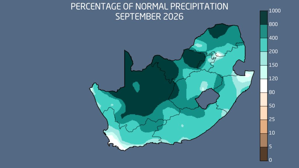
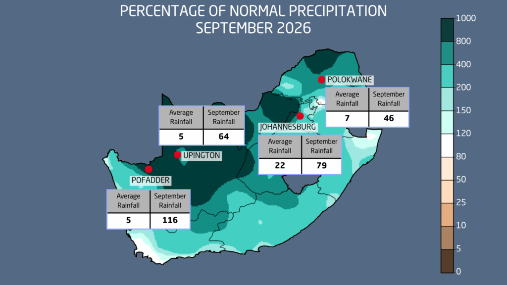
September was unusually wet across much of South Africa, with several locations recording rainfall totals far exceeding their long-term monthly averages.
Johannesburg received approximately 3.5 times its normal September rainfall, while Polokwane recorded almost 7 times its monthly average. Further west, the figures were even more remarkable, with Upington receiving nearly 14 times its normal rainfall and Pofadder approximately 24 times its September average.
These figures do, however, require some context. The Northern Cape typically receives very little rainfall during September. Pofadder, for example, has a long-term September average of only around 5 mm. Consequently, even relatively modest rainfall totals can translate into exceptionally large percentage anomalies.
Nevertheless, the widespread and unusually high rainfall totals highlight just how remarkable September 2026 was.
What Caused the Unusually Wet Conditions?
Much of September’s rainfall was associated with a series of cut-off low-pressure systems, which are known to produce widespread rainfall, thunderstorms and, in some cases, significant flooding across South Africa.
Although cut-off lows are not uncommon during spring, the frequency of favourable upper-air conditions during September 2026 was particularly unusual.
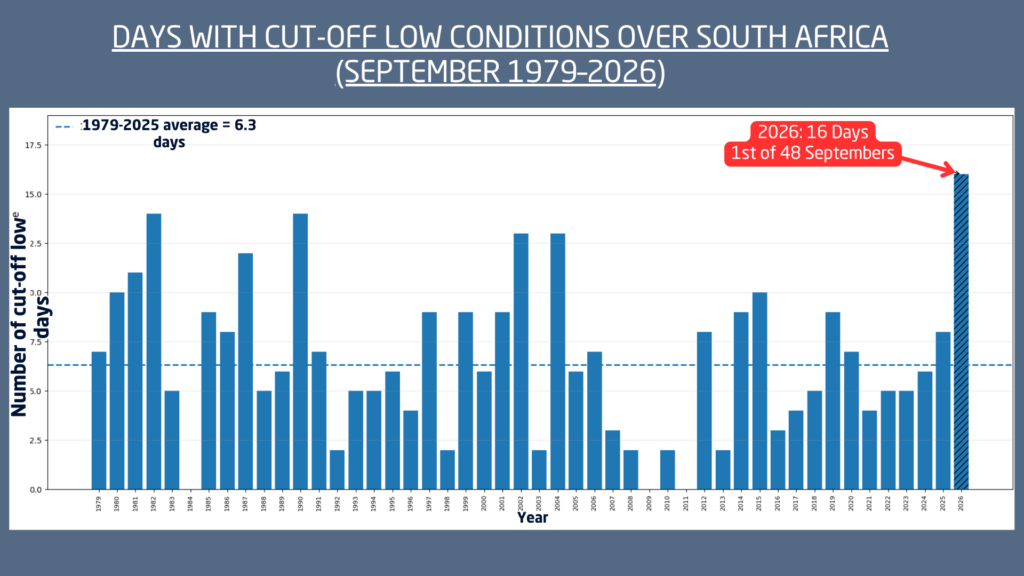
An analysis by Vox Weather, using ERA5 upper-air reanalysis data covering September from 1979 to 2026, identified 16 days during September 2026 when atmospheric conditions strongly resembled those typically associated with cut-off lows.
This compares with a long-term September average of approximately 6.3 days, making September 2026 the most active September in the 48-year period analysed according to this measure.
Importantly, this does not mean that 16 separate cut-off low systems occurred. A single system can persist for several days. Rather, the analysis highlights the exceptionally persistent and active upper-air weather patterns experienced during the month.
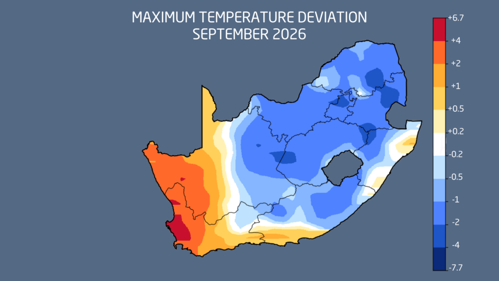
These systems also contributed to cooler-than-normal maximum temperatures across large parts of the country, although portions of western South Africa experienced warmer conditions associated with frequent berg winds.
Is El Niño Still Developing Despite All the Rain?
Yes. South Africa’s unusually wet September does not mean that El Niño has disappeared or that its potential impacts are no longer a concern.
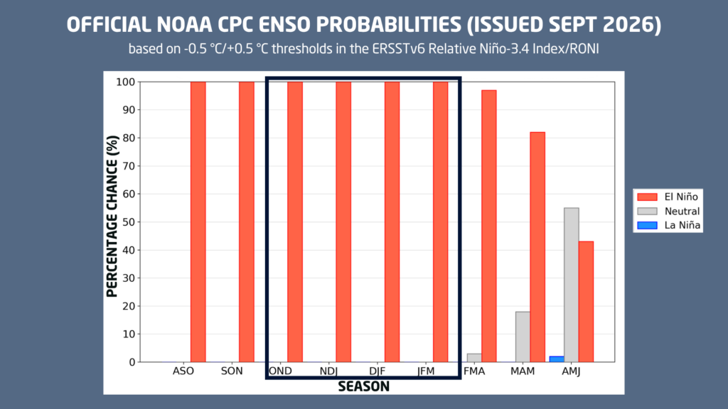
El Niño conditions are currently present in the tropical Pacific Ocean, with further strengthening expected towards November and December 2026.
El Niño is characterised by unusually warm sea surface temperatures across the central and eastern equatorial Pacific Ocean. These changes influence large-scale atmospheric circulation patterns and can affect rainfall and temperature across many parts of the world, including southern Africa.
Historically, El Niño events have often been associated with hotter and drier summer conditions across South Africa’s summer rainfall regions.
However, this relationship is not absolute.
El Niño increases the probability of below-normal seasonal rainfall, but it does not mean that rainfall will stop altogether. Individual weather systems, regional circulation patterns and other global climate influences continue to play important roles.
The exceptionally wet conditions experienced during September serve as a reminder that even during a strong El Niño, significant rainfall events can still occur.
How Long Could El Niño Last?
Current ENSO predictions indicate that El Niño is expected to remain strong through the remainder of 2026, with peak intensity anticipated around November or December.
Thereafter, a gradual weakening is expected during the first half of 2027.
Forecast guidance suggests a possible return to ENSO-neutral conditions around April to June 2027, although uncertainty naturally increases further into the forecast period.
It is also important to remember that the atmospheric impacts of El Niño do not necessarily disappear immediately as sea surface temperatures begin returning towards neutral levels.
Summer Rainfall Outlook: An Increasing Risk of Drier Conditions
Seasonal forecasts from the South African Weather Service (SAWS) and the University of Pretoria (UP) indicate an increasing risk of below-normal rainfall across parts of South Africa during the core summer months.
The SAWS outlook for November 2026 to January 2027 generally favours below-normal rainfall across substantial portions of the summer rainfall region.
The University of Pretoria’s seasonal outlook also indicates areas with an increased likelihood of drier conditions, although the signal is less widespread and less pronounced in some regions.
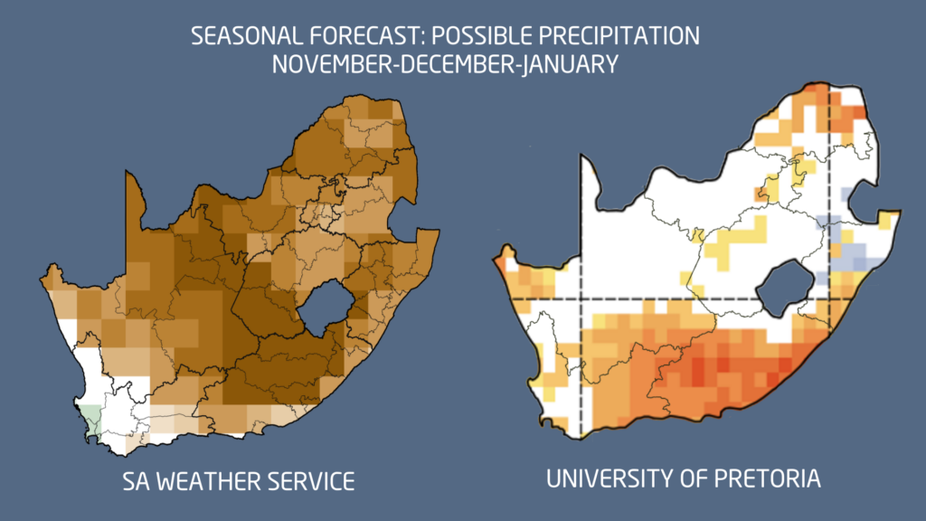
These differences highlight the uncertainty that remains in seasonal rainfall predictions.
While the overall outlook suggests an elevated risk of below-normal rainfall, it is important to remember that seasonal forecasts describe probabilities rather than guaranteed outcomes.
Even during a drier-than-normal summer, individual rainfall events may still produce significant totals, and some areas could receive near-normal or above-normal rainfall.
Another important consideration is the timing and distribution of rainfall. A season with near-normal total rainfall can still present agricultural challenges if prolonged dry spells occur during critical crop development stages.
Summer Temperature Outlook: Stronger Confidence in Above-Normal Heat
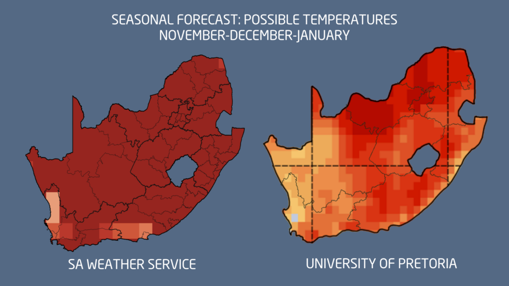
While uncertainty remains regarding rainfall, there is stronger agreement between seasonal forecasting models that the coming summer will be warmer than normal across much of South Africa.
Both SAWS and the University of Pretoria indicate an increased likelihood of above-normal temperatures during November, December and January.
Higher temperatures can increase evaporation rates and accelerate the loss of soil moisture, particularly during extended periods without rainfall.
For agriculture, the combination of above-normal temperatures and below-normal rainfall could increase the risk of heat stress, particularly for crops approaching sensitive growth stages. Hotter conditions may also increase water demand, place additional pressure on irrigation resources and contribute to elevated fire danger in susceptible regions.
Importantly, a warmer-than-normal season does not necessarily mean every day will be exceptionally hot. Rather, it indicates that average temperatures over the three-month period are more likely to exceed their long-term norms.
Improved Soil Moisture Offers a Valuable Buffer
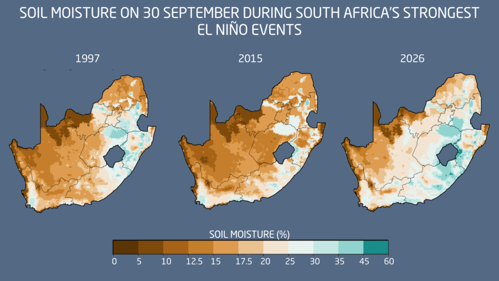
One of the more encouraging developments ahead of the 2026/27 summer season is the favourable soil moisture conditions across many parts of South Africa following the unusually wet spring.
Vox Weather’s analysis of soil moisture conditions suggests that several regions entered the summer growing season with more favourable moisture reserves than those observed around the beginning of previous strong El Niño seasons, including 1997/98 and 2015/16.
This could provide an important advantage for agricultural producers.
Adequate soil moisture can support early crop establishment, promote initial growth and help crops withstand shorter periods of below-normal rainfall.
However, favourable soil moisture at the beginning of summer does not guarantee a successful agricultural season.
If prolonged dry spells develop later in the season, particularly alongside persistently high temperatures, existing moisture reserves could become depleted.
The timing of future rainfall will therefore remain critical.
January and February Could Be Crucial for Agriculture
Despite the increased likelihood of a hotter and potentially drier summer, the outlook does not automatically imply a poor agricultural season.
The improved soil moisture following September’s exceptional rainfall provides an encouraging starting point.
However, January and February 2027 are likely to be particularly important months to monitor, as many summer crops enter critical flowering and grain-filling stages.
During these stages, prolonged dry spells and excessive heat can significantly affect crop development and potential yields.
Ultimately, the distribution and timing of rainfall may prove just as important as the total amount received throughout the season.
The Bottom Line
South Africa enters the 2026/27 summer season following an exceptionally wet September, with improved soil moisture across many regions.
However, a strengthening El Niño and seasonal forecasts favouring above-normal temperatures and an increased risk of below-normal rainfall suggest that challenges may still lie ahead.
A drier summer does not necessarily mean a failed agricultural season, and El Niño does not mean an absence of rainfall.
The key will be how rainfall and temperature patterns evolve during the heart of summer, particularly in January and February.
Vox Weather will continue monitoring El Niño developments, seasonal forecast updates and the evolving conditions across South Africa to keep the public and agricultural community informed.