Nature Unleashed as the Western and Eastern Cape Experience Severe Winter Weather
We saw eight weather warnings in place recently as a second, and stronger, cold front moved over the south-western Cape in quick succession, bringing damaging winds and disruptive rain. Vox Weather Meteorologist Michelle du Plessis shares a short overview.
(Cover image courtesy of SABC News: Facebook)
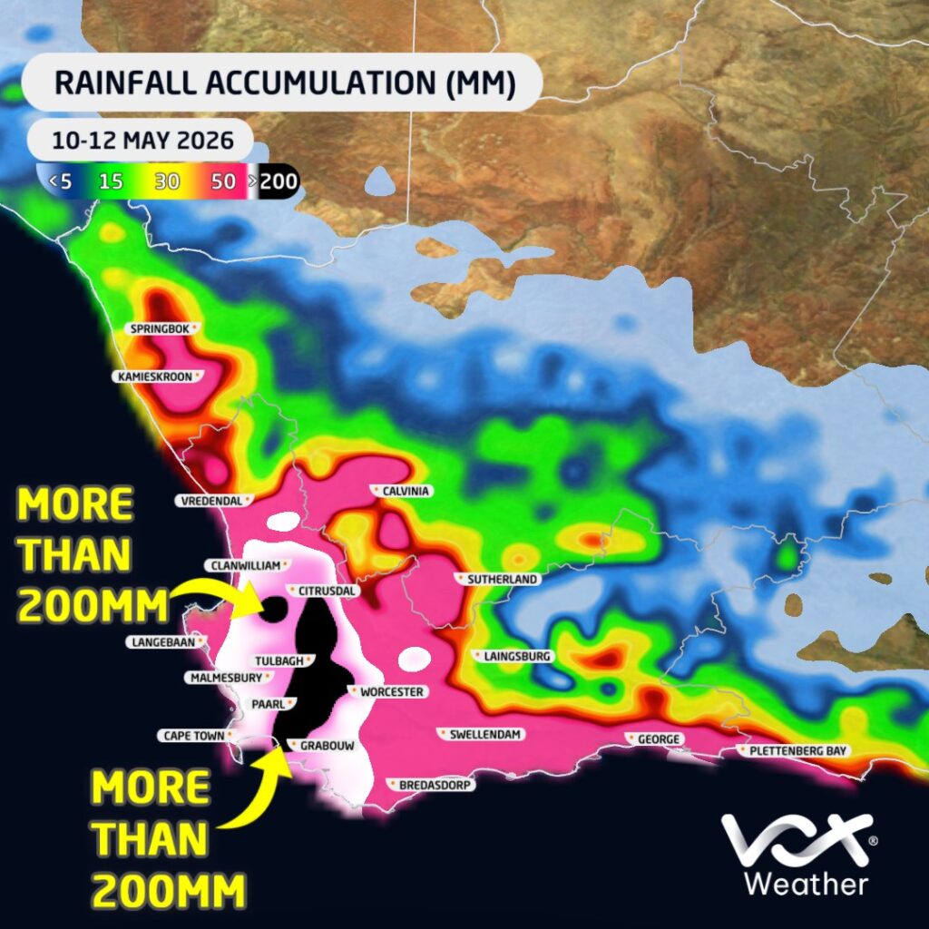
Two consecutive cold fronts moved across the south-western parts of South Africa this week (10 to 15 May), bringing widespread heavy rain, damaging winds and major disruptions across parts of the Western Cape.
The first cold front moved through on Sunday the 10th of May, followed by a second and stronger system on Monday the 11th. This second front brought the most intense weather, with heavy rainfall continuing into Tuesday the 12th across several areas.
Widespread Flooding and Disruptions
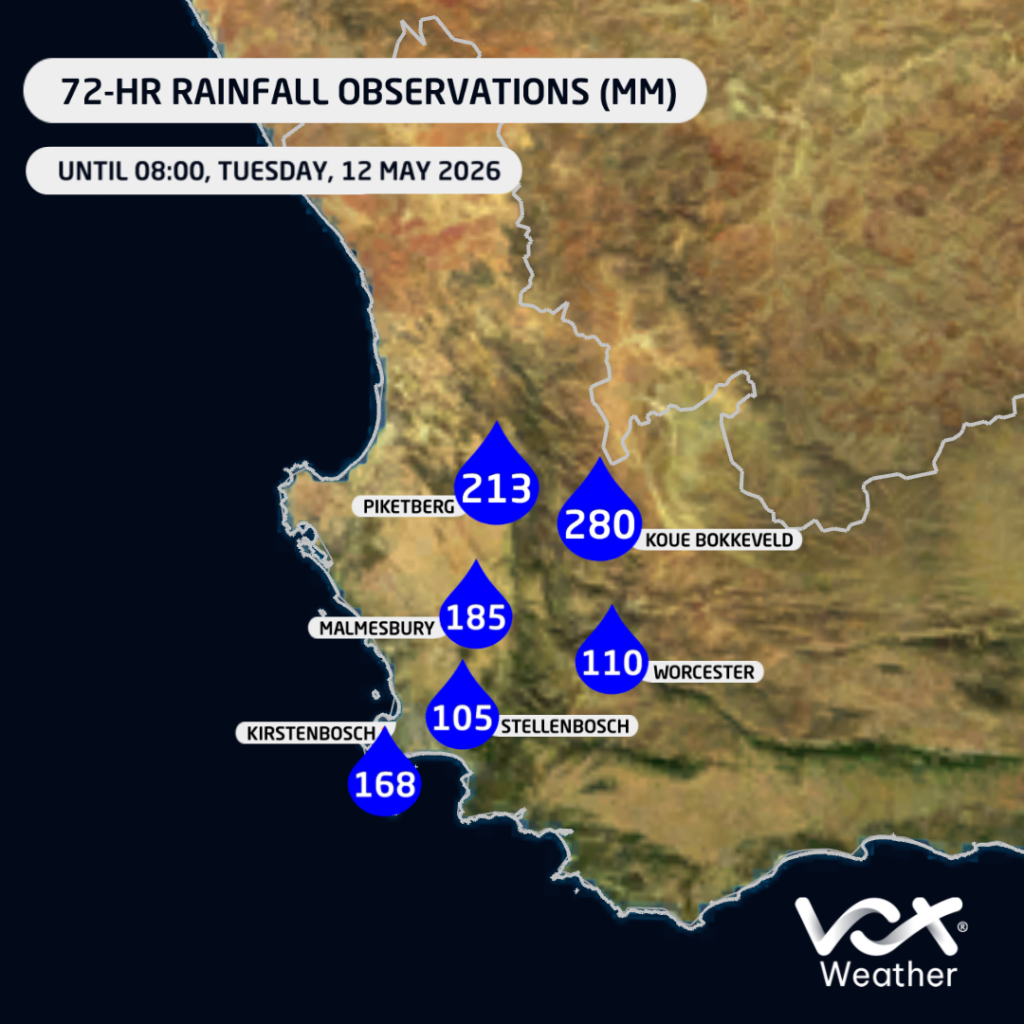
Rainfall totals were particularly significant across the western and south-western parts of the province. Several public reports indicate very high accumulations, including around 213 mm near Piketberg by Tuesday morning, with rain still continuing at the time of the report.
In the Koue Bokkeveld, between Ceres and the Cederberg, some areas reportedly received up to around 280 mm, with ongoing rain, road closures, power outages, limited internet access and cellphone tower disruptions being reported.
Some areas may even have received more than 300 mm, particularly some of the mountainous regions.
These very high totals led to widespread flooding and disruptions, with several schools in the Western Cape closed on Tuesday due to the severe weather conditions.
Damaging Winds
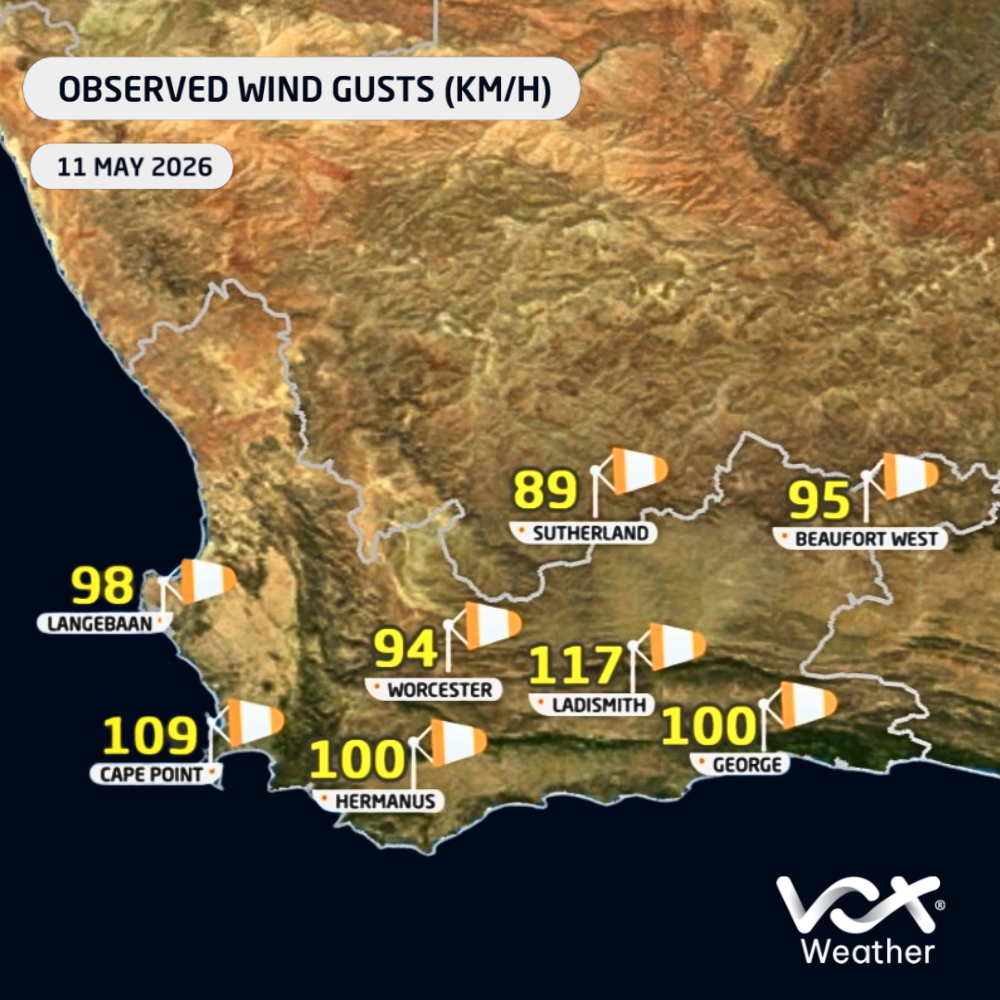
The heavy rain was not the only major concern. Damaging winds were also a significant component of this system.
Official 24-hour wind gust observations for Tuesday showed gusts of 117 km/h at Beaufort West and Ladismith, 113 km/h at Ngqura, 109 km/h at Cape Point, 100 km/h at Sutherland, 98 km/h at Dohne, 94 km/h at Hermanus, 93 km/h at Laingsburg, and 91 km/h at both Cape Town AWS and Uitenhage.
Some private weather station reports indicated even stronger gusts, including a reported maximum wind gust of 142 km/h near Piketberg.
These strong winds contributed to widespread damage, including power outages, fallen trees, infrastructure damage and transport disruptions. The closure of the N1 towards Cape Town near Worcester was particularly significant, as it affected a major transport route into the city and likely disrupted the movement of goods and services. A number of flights from the Cape Town and George airports were also affected.
Nature Unleashed
This event highlights the tremendous potential impact of winter cold fronts when multiple systems move through in quick succession. The combination of saturated ground, persistent rainfall, strong winds and rough conditions can quickly lead to flooding, infrastructure damage, travel delays and power supply challenges.
Although strong cold fronts are a normal part of the Western Cape winter rainfall season, this event was particularly significant because of the intensity of the second front, the high rainfall totals over a short period, and the widespread damaging winds.
Conditions are expected to improve from Wednesday as the second cold front moves away from the province. The latest forecast currently indicates dry conditions across most regions of the Western Cape for the rest of the week.