Why it is still too early to make drought predictions for South Africa

After one of the better rainfall seasons so far across parts of South Africa’s summer rainfall areas, a new concern is starting to draw attention: the possibility of a strong, or even ‘Super’, El Niño later in 2026. This has already raised concern among farmers, agricultural businesses, water planners and other weather-sensitive industries. However, says Vox Weather Meteorologist Michelle du Plessis, it is important to approach the topic carefully.

While the chance of El Niño developing later this year is increasing, it is still too early to make direct drought predictions for South Africa. At this stage, the best message is one of awareness and preparation, not panic. We unpack this in the article.

What is El Niño?

El Niño forms part of the El Niño-Southern Oscillation, commonly known as ENSO. ENSO is a natural climate pattern linked to changes in sea surface temperatures and atmospheric pressure across the central and eastern equatorial Pacific.

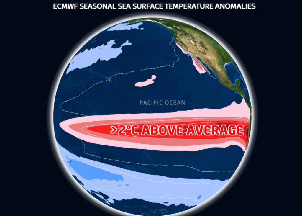
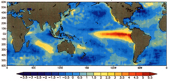
During El Niño, sea surface temperatures in the central and eastern equatorial Pacific Ocean become warmer than normal. This warming can influence global weather patterns by shifting large-scale atmospheric circulation. 

In southern Africa, El Niño is often associated with a greater chance of hotter and drier conditions during the summer rainfall season, especially over the interior summer rainfall regions.

However, El Niño does not affect every country or every season in the same way. It also does not automatically mean that drought will occur.

What are the latest forecasts showing?

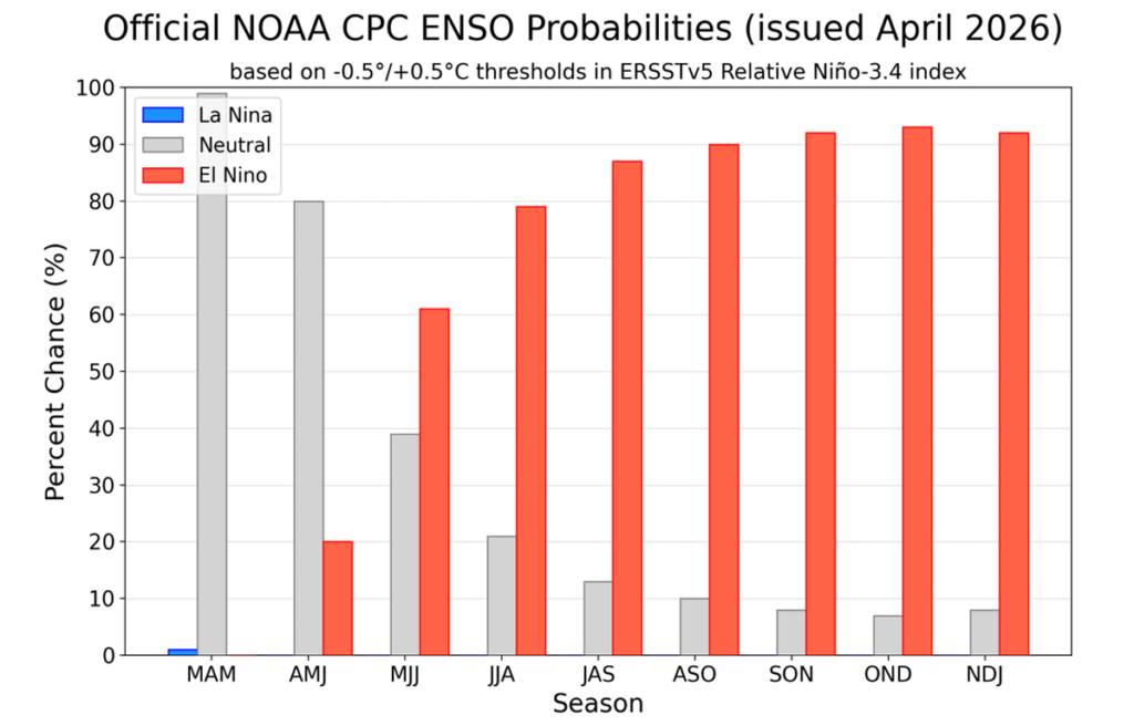
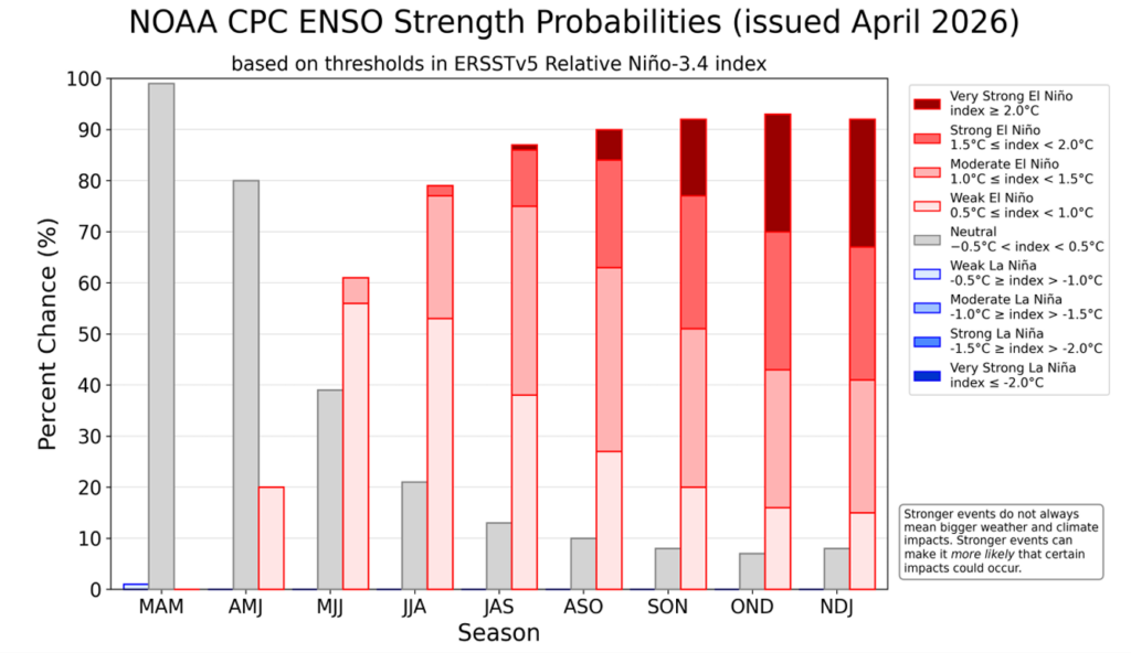
According to the latest outlook from the US Federal Agency, the National Oceanic and Atmospheric Administration (NOAA), ENSO-neutral conditions are currently present, but El Niño is likely to develop during May to July 2026. NOAA gives a 61% chance of El Niño emerging during this period and continuing through at least the end of 2026.

NOAA also indicates a roughly one-in-four chance that the event could become very strong later in the year, but notes that this depends on whether the atmospheric conditions over the equatorial Pacific continue to support further strengthening.

The World Meteorological Organization (WMO) has also highlighted that ENSO-neutral conditions are expected in the short term, while the probability of El Niño increases later in 2026. WMO’s earlier update indicated around a 60% chance of neutral conditions during May to July, with the chance of El Niño rising to around 40% during that same period.

Here at home, the University of Pretoria’s Seasonal Forecast Worx April 2026 update also points towards the possible development of a strong El Niño state towards the end of 2026.

This means there is growing agreement that El Niño may develop later this year, but there is still uncertainty about how strong it will become and how directly it will affect South Africa.

What does ‘Super El Niño’ mean?

The term ‘Super El Niño’ is often used in the media to describe an exceptionally strong El Niño event. In scientific discussions, a very strong El Niño is usually linked to sea surface temperature anomalies in the Niño 3.4 region reaching around +2.0°C or more.

However, ‘Super El Niño’ is not always used consistently. It can sound dramatic, and it can create the impression that severe drought is already guaranteed. That is not the case.

A strong El Niño increases the probability of certain climate impacts, but it does not guarantee the same outcome in every country. For South Africa, the strength of El Niño is important, but it is not the only factor that determines rainfall.

Too early to make drought predictions for South Africa

It is still too early to directly link the expected El Niño to a specific drought outcome for South Africa.

One reason is that ENSO forecasts are generally less reliable during the late autumn and winter months. Forecast confidence usually improves from around August and September, when the Pacific Ocean and atmosphere are more clearly coupled and the signal for the coming summer rainfall season becomes stronger.

This is especially important for South Africa, because the main ENSO-related impacts are usually felt during the summer rainfall season, from around October or November through to March. The current winter period is not expected to be significantly influenced by the developing El Niño signal.

For this reason, any strong statements about drought over South Africa should be treated with caution at this stage. It is more responsible to say that the risk of hotter and drier summer conditions may increase if a strong El Niño develops, but it is not yet possible to confirm the timing, severity or regional detail of those impacts.

South Africa’s rainfall is influenced by more than ENSO

Although El Niño is an important climate driver, South Africa’s rainfall is influenced by several other factors as well.

These include the position of high-pressure systems, moisture transport from the tropics and Indian Ocean, cut-off lows, tropical-temperate cloud bands, regional circulation patterns, sea surface temperatures near southern Africa, and shorter-term weather systems.

This means that even during El Niño years, rainfall can still vary significantly from one region to another. Some areas may experience long dry spells, while others may still receive important rainfall events.

It is also important to remember that only the summer rainfall regions of South Africa are typically more directly influenced by ENSO. The winter rainfall region, especially the Western Cape, is not affected in the same way during winter.

What can we learn from past strong El Niño events?

Historically, South Africa has experienced different outcomes during strong El Niño events.

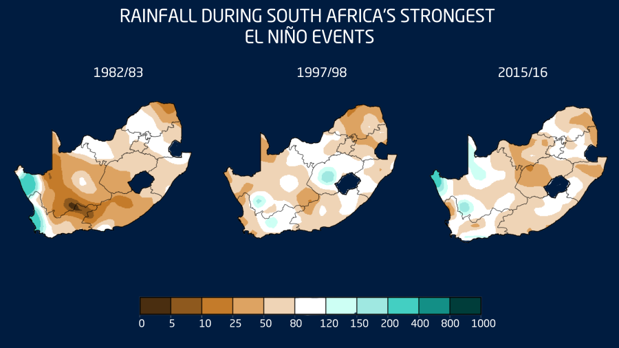
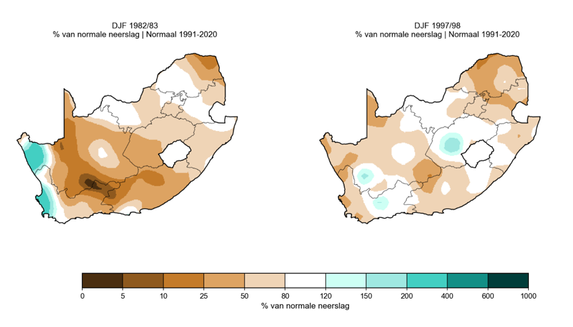
The 1982/83 El Niño was linked to severe agricultural impacts and is remembered as one of the more damaging events for crops. However, the 1997/98 event, although globally one of the strongest El Niño events on record, did not produce the typical widespread hotter and drier summer season over South Africa in the same way.

This shows why we cannot simply say “strong El Niño equals drought”. The relationship is important, but it is not perfect.

El Niño increases the risk of certain conditions, but the final impact depends on how it interacts with other climate drivers during the season.

What could this mean for South Africa if a strong El Niño develops?

If a strong El Niño develops and persists into the 2026/27 summer rainfall season, South Africa’s summer rainfall areas may face an increased risk of warmer and drier conditions compared with normal.

  • For daily life, this could mean a greater chance of heatwaves, higher water demand, increased fire-weather risk in some areas, and pressure on household and municipal water use.
  • For agriculture, the main concern would be the timing and distribution of rainfall during the planting and growing season. Even if seasonal rainfall totals are not extremely low, poor rainfall timing, long dry spells between rainfall events, or very hot conditions during sensitive crop stages can still place crops and livestock under pressure.
  • For weather-sensitive industries such as mining, construction, tourism, logistics and supply chains, a hotter and drier summer could increase operational challenges. These may include heat-related working conditions, dust, water-use pressure, veld fire risk, and possible knock-on effects on agricultural production and food prices.

However, these remain possible risks, not confirmed outcomes.

What should farmers and weather-sensitive industries do now?

The key message is to prepare practically, but not to panic.

Farmers should monitor seasonal updates closely over the next few months, especially from August and September onwards when confidence in the summer outlook should improve. It may also be useful to start reviewing water availability, irrigation planning, planting decisions, fodder reserves, livestock heat-stress plans and financial risk strategies.

At the same time, short-term forecasts remain the most useful tool for immediate decision-making. A possible El Niño later in the year does not replace the need to monitor weekly rainfall systems, cold fronts, cut-off lows, heatwaves and severe weather warnings.

Is climate change making El Niño worse?

El Niño is a natural climate phenomenon. It is not caused by climate change. However, it now occurs in a warmer global climate system.

This means that when a strong El Niño develops, it can add to already elevated global temperatures and increase the likelihood of heat-related extremes in some parts of the world. A strong El Niño in a warmer world can therefore have amplified impacts, especially when it comes to temperature.

For South Africa, this means that if a strong El Niño develops, the heat component may be particularly important to monitor during the 2026/27 summer season.

The key message for South Africa

There is growing evidence that El Niño may develop later in 2026, and there is a possibility that it could become strong. However, it is still too early to confirm a ‘Super El Niño’ or make direct drought predictions for South Africa.

The most responsible message is that the risk of hotter and drier conditions may increase for the summer rainfall areas during the 2026/27 summer season, especially from October or November into March, but this risk still needs to be monitored carefully over the coming months.


For now, South Africans should remain informed, follow trusted seasonal updates, and continue to use short-term forecasts for practical day-to-day planning.

A possible strong El Niño is something to watch closely, not something to treat as a guaranteed drought forecast.

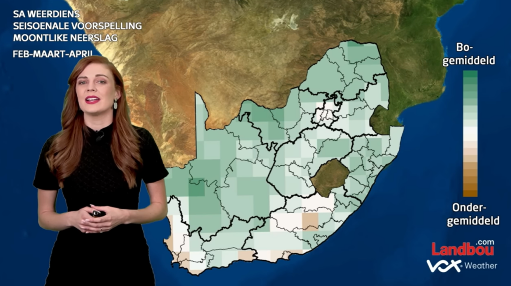
When you look at recent weather maps of South Africa, you could be forgiven for thinking that we are living in two different countries. Vox Weather Meteorologist Michelle du Plessis shares the first seasonal outlook of 2026.

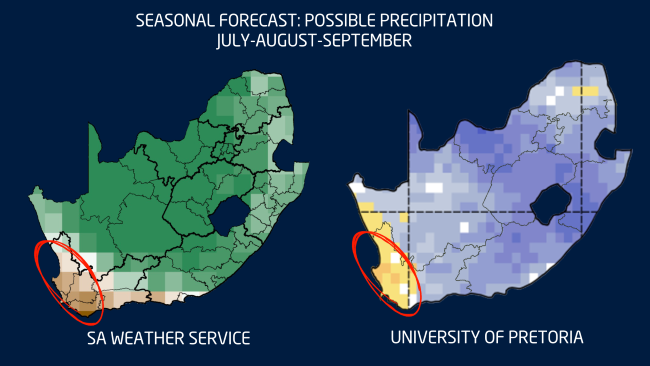
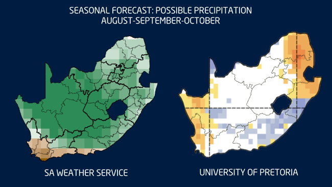
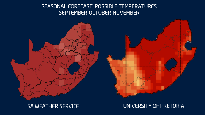
Please note: All graphs and images are taken from the latest Langtermyn Landbou-Weervoorspelling, and the text on the visuals is in Afrikaans. You can also view the Landbou show here.

The first agricultural weather outlook of 2026 begins with a country already deeply shaped by summer weather extremes. While large parts of South Africa experienced intense thunderstorms, flooding and high humidity in December, the western regions faced the opposite: extreme heat, dryness and severe fire danger.

The key question now is whether December was just a noisy outlier, or whether it signals a broader pattern for the rest of summer and early autumn.

December 2025: A month of extremes

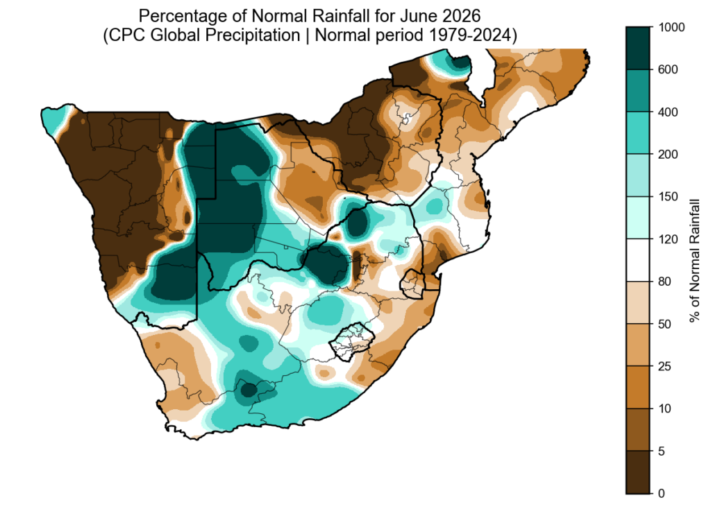
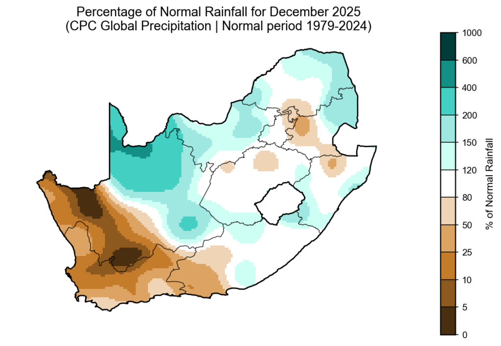
According to the CPC percent-of-normal rainfall map for December 2025 (based on the 1979–2024 climate period), a classic summer contrast emerged across the country.

The northern, central and eastern regions recorded above-normal rainfall, while the south-western and western areas — particularly the Western Cape, southern Cape and parts of the Northern Cape — were much drier than normal.

Although the Western Cape normally receives most of its rainfall in winter, 2025 was exceptionally dry. It now ranks among the three driest years of the past four decades for the province.

Severe convective storms in the north and east

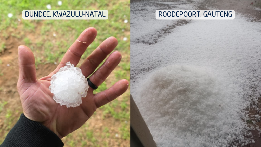
The above-normal rainfall across the summer-rainfall region was driven by powerful cumulonimbus thunderstorms. These towering cloud systems are responsible for lightning, hail, intense downpours and flash flooding.

Large parts of the northern and eastern provinces saw repeated thunderstorm outbreaks. A particularly shocking event occurred in the Majaneng area near Hammanskraal, where reports indicated that around 40 people were struck by lightning around 3 January.

Several storms also produced large hail, causing localised agricultural and property damage. Flooding was widespread in areas where storms repeatedly tracked over the same catchments.

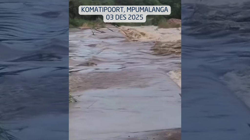
In the Lowveld, impacts became severe. On 3 December, a vehicle carrying eight people was swept away at the Komatipoort low-water bridge by the swollen Nkomazi River, highlighting how deadly summer river crossings can become.

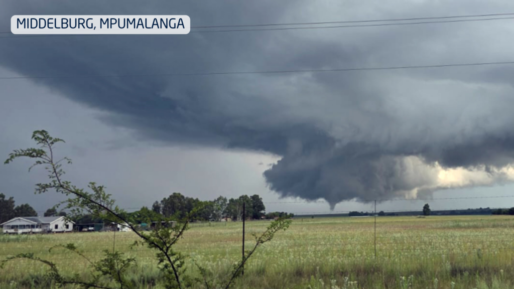
On New Year’s Day, two tornadoes were confirmed in Mpumalanga, near Middelburg and Carolina, causing damage to buildings and infrastructure.

Extreme fire season in the west

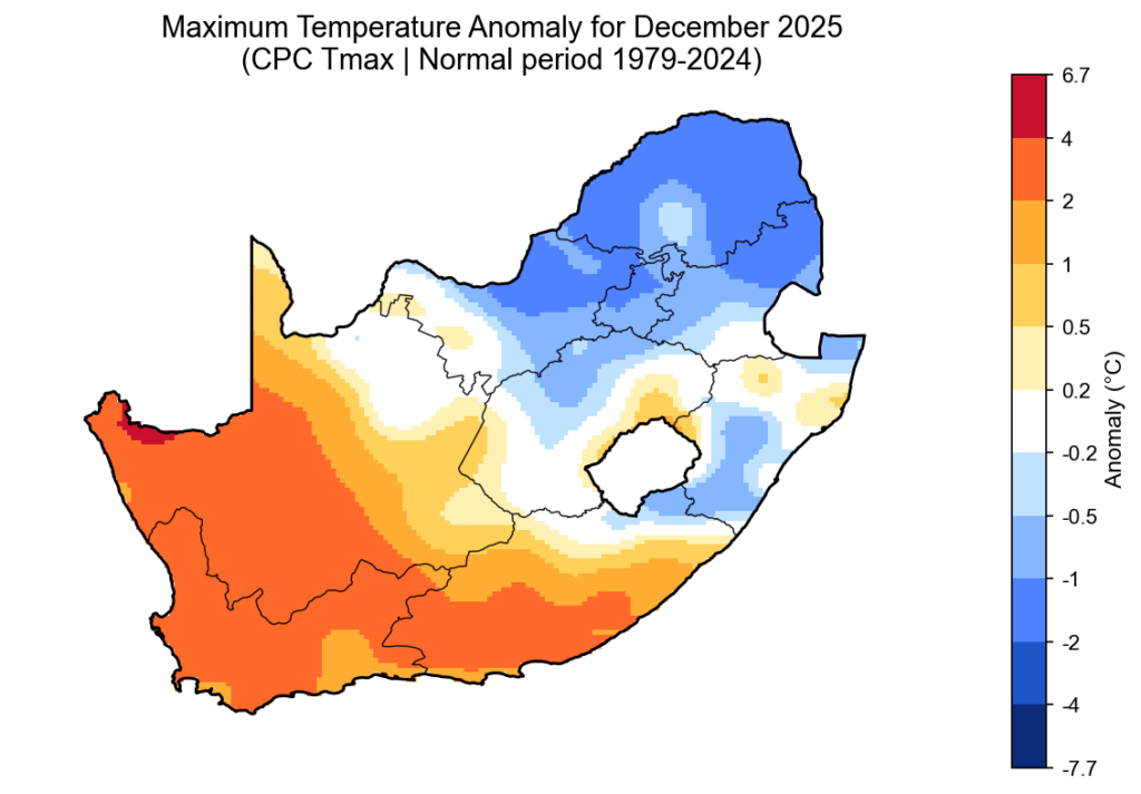
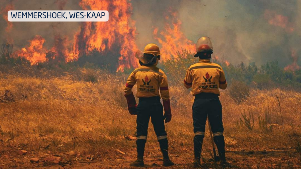
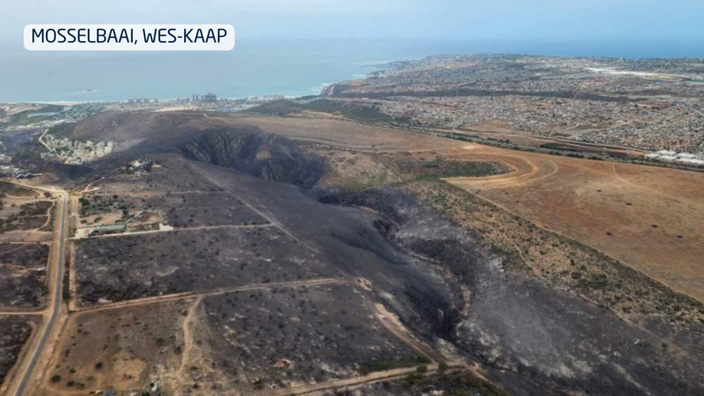
While storms dominated the east, the western parts of the country endured heat, strong winds and very little meaningful rainfall. This combination triggered one of the most severe fire seasons in years.

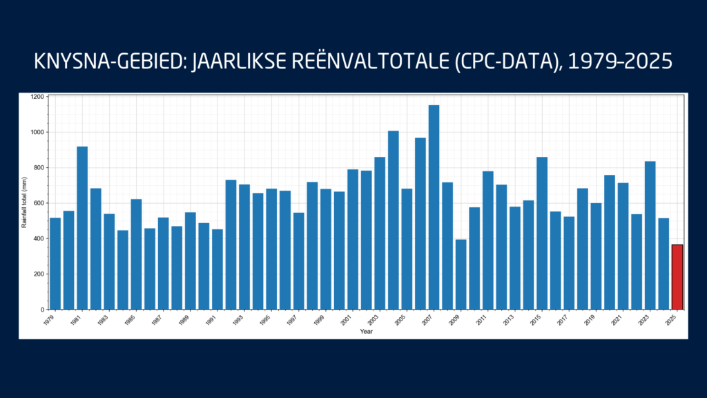
These fires occurred while the southern Cape was already under severe water stress. Knysna entered Level 4 water restrictions, with only days of usable water left in the Akkerkloof Dam. Rainfall records show that 2025 was the driest year in over 40 years for the area, pushing the town dangerously close to so-called Day Zero.

Disaster management confirmed that at least 10 major wildfires burned over a single intense week, destroying approximately 90,000 hectares and damaging dozens of structures.

What ENSO is telling us

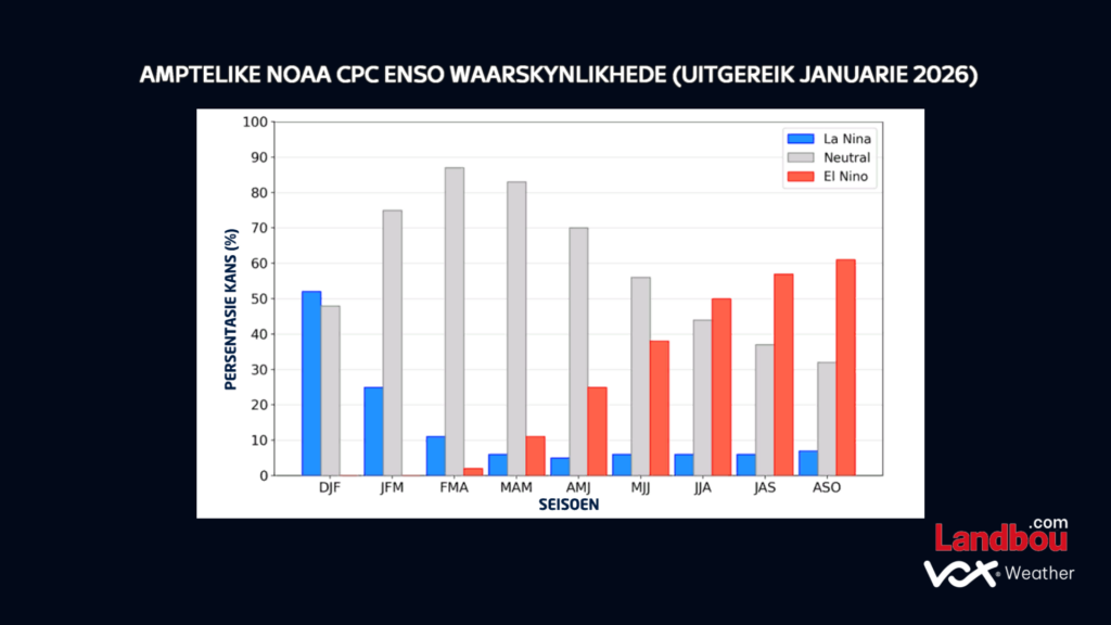
The latest ENSO indicators continue to show La Niña conditions persisting through the rest of summer. These are expected to weaken into neutral conditions during autumn, while the probability of El Niño increases toward late winter and early spring.

For agriculture, this suggests:

  • Above-normal rainfall risks continue in the east during late summer
  • More variable conditions into autumn
  • A growing risk of warmer and drier conditions later in the year as El Niño develops

Water resources under pressure

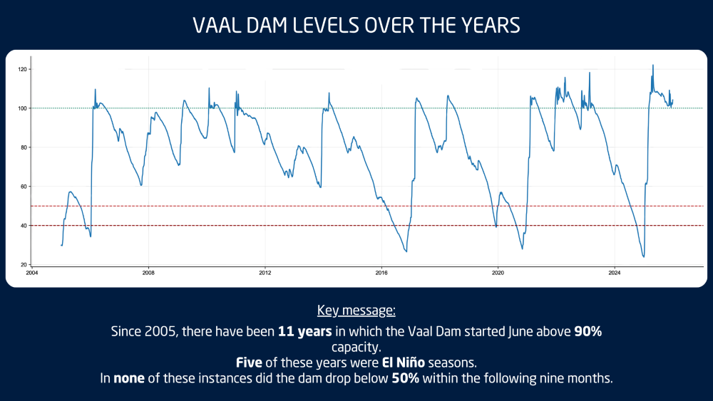
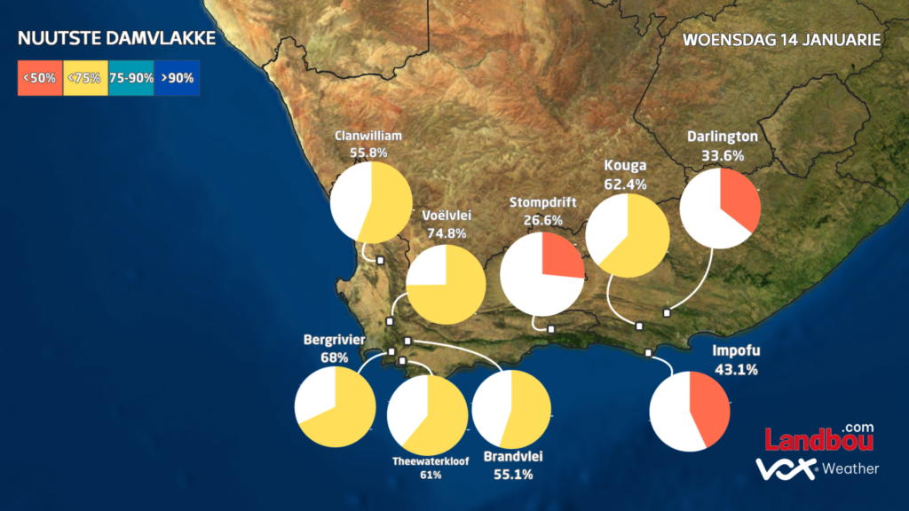
The Western Cape’s dam levels currently average 66.3%, down sharply from 86.5% at the same time last year. This significant drop highlights how vulnerable the region already is before the winter rainfall season even begins.

In the Eastern Cape, dam levels also remain below last year’s levels, averaging 75.4% compared to 81.3% a year ago. Although the Eastern Cape forms part of South Africa’s year-round rainfall zone, this does not mean rainfall is evenly distributed. Over recent months, most of the rain has fallen further north and east, with major systems missing much of the southern and eastern Cape. This explains why, despite its climate, the region is still under water pressure.

What this means for the months ahead

December was not an isolated event. It reflects a broader climate pattern of:

  • Wet, storm-prone conditions in the east
  • Hot, dry and fire-prone conditions in the west
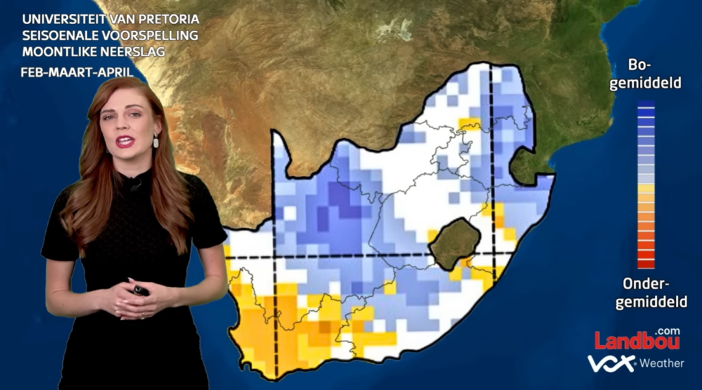
  • The seasonal outlook suggests this contrast is likely to persist through late summer and early autumn.

For farmers, this means that in the east and Lowveld, there is continued risk of flooding, crop disease and soil erosion; while in the west, there will be ongoing pressure on water resources, fire management and drought planning.

Seasonal models cannot predict individual storms, but they do provide reliable guidance on overall trends. And the trend for early 2026 is already clear:
A wet east, a dry west, and significant agricultural challenges across both.