Winter 2026 – How Are We Tracking?
Winter in South Africa runs officially from the beginning of June to the end of August – that is, from a meteorologist’s point of view. So even if we get icy weather in May, we’re still only ‘officially’ in Autumn! Meteorological seasons are based on calendar months and average annual temperature cycles, making them more consistent for record-keeping and climate analysis.
And so, as we move towards mid-July and the halfway mark of winter, Vox Weather Meteorologist Michelle du Plessis gives us an update on winter so far, and what the coming months might bring.
June Rainfall and Temperature Patterns
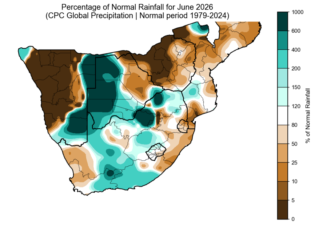
June rainfall anomalies show that some seasonal models correctly picked up on the drier start to winter over the far west. However, June was not dry everywhere. More than one cut-off low system brought above-normal rainfall to parts of the summer rainfall region and the Southern Cape. Southern Namibia also stood out, with some areas receiving up to six times their normal monthly rainfall.
Although it may have felt cold at times, June was surprisingly warm overall. Across large parts of South Africa, both morning and daytime temperatures were above normal. Provincial temperature analysis shows that the Free State, North West, Northern Cape and KwaZulu-Natal recorded their warmest average June temperatures since 1979, and possibly their warmest June on record.
El Niño Is Here
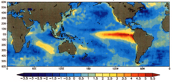
El Niño is currently one of the biggest talking points in weather and agriculture. But it is important to remember that El Niño is not something that will suddenly ‘hit’ South Africa – it has already started developing over the Pacific Ocean.
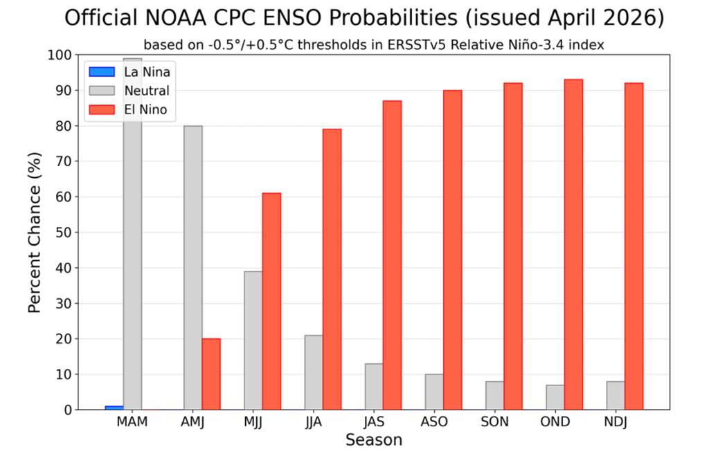
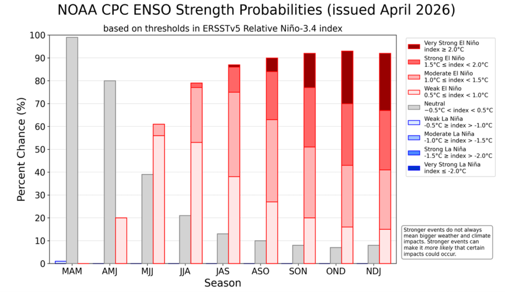
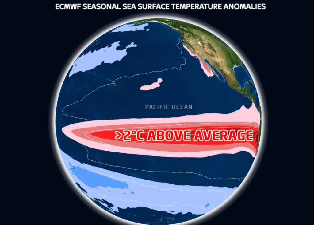
We are currently in weak El Niño conditions, meaning sea surface temperatures over the central and eastern Pacific Ocean are warmer than normal. El Niño is expected to continue through winter and spring, with an 81% chance of developing into a very strong event during October to December 2026. This would rank it among the largest El Niño events in the historical record dating back to 1950.
A very strong, or so-called ‘super’ El Niño, usually refers to an event where sea surface temperatures across large parts of the central and eastern Pacific remain more than 2°C above normal for an extended period.
Does A Strong El Niño Always Mean Drought?
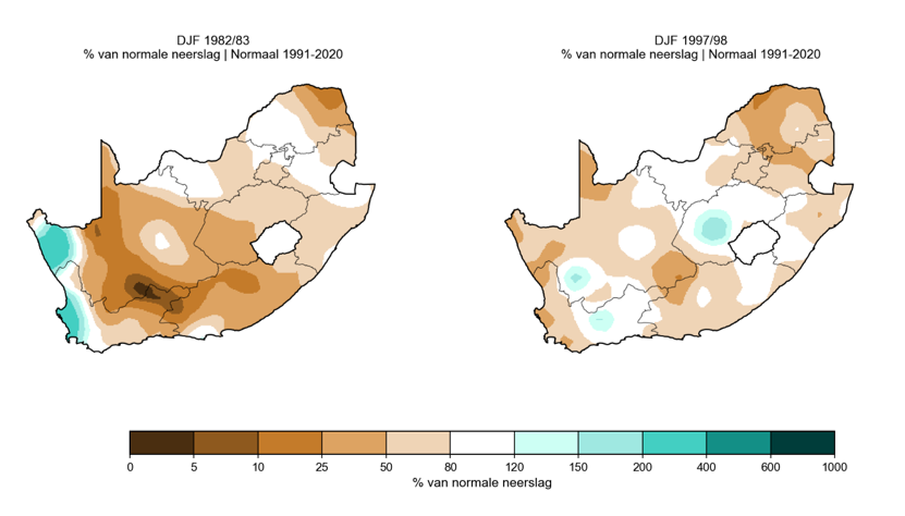
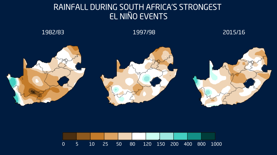
No. South Africa has experienced strong El Niño events before, and they have not all produced the same outcome. During strong El Niño events in the 1980s and 1990s, many areas did experience drier-than-normal conditions, especially over the summer rainfall region. However, there were also parts of the country that still received normal or even above-normal rainfall, including parts of North West and the Free State during the 1997/1998 summer.
The major exception was 2015/2016. That was one of the strongest El Niño events on record and contributed to one of the worst droughts in modern South African history.
The key message is this: a strong El Niño does not guarantee drought. It increases the risk of drier-than-normal conditions, especially over the summer rainfall region.
A Better Starting Point Than 2015/2016
There is also some good news. Many dams are currently in a healthy state, and soil moisture looks better over large parts of the country than it did before the 2015/2016 drought.
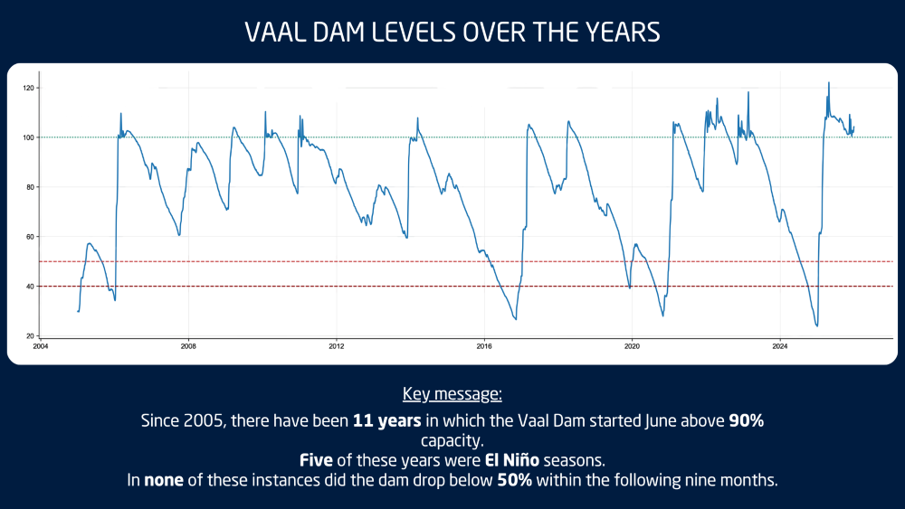
The Vaal Dam is a good example. Since 2004, there have been 11 years where the Vaal Dam started June above 90% full, similar to this year. In all 11 of those years, the dam remained above 50% for the following nine months. Five of those years were El Niño seasons, including 2018 and 2023.
This does not mean we can relax, but it does give South Africa a stronger starting point if the coming summer does turn warmer and drier.
Seasonal Outlook: Winter Into Spring
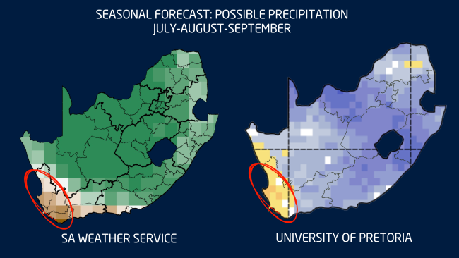
Looking at the rest of winter and the start of spring, both the SA Weather Service and University of Pretoria forecasts agree broadly on one thing: the far west is likely to remain drier than normal.
There are still indications of above-normal rainfall over parts of the interior, especially where cut-off lows or upper-air low-pressure systems may develop. This is a pattern we started seeing in June already, with weaker cold fronts over the Western Cape and more active upper-air systems over the interior.
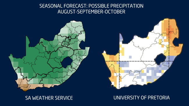
By late winter and early spring, the models begin to differ more noticeably. The SA Weather Service shows a possible wetter-than-normal signal over parts of the interior, while the University of Pretoria forecast is more mixed and even shows a drier signal in some areas.
This difference highlights the uncertainty that still remains. The atmosphere has not yet fully decided how it will respond to the developing El Niño.
Summer Outlook: Heat May Be the Bigger Risk
While below-normal rainfall remains an important risk, the biggest concern this summer may not only be drought, but extreme heat.
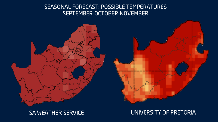
Most seasonal forecasts agree that South Africa can expect warmer-than-normal conditions from spring. This increases the chance of more frequent, longer and more intense heatwaves during the coming summer.
Higher temperatures also mean higher evaporation, increased water demand for crops and livestock, and greater pressure on soil moisture. When thunderstorms do develop, the extra heat and moisture can also help fuel more intense, isolated storms. So even in a season with a drier overall signal, heavy downpours, hail and localised flooding can still occur.
What Should Farmers and the Public Take from This?
- Do not rely on one seasonal forecast alone. Seasonal forecasts give us an indication of the most likely scenario, but they are not exact predictions of what will happen on every farm.
- Plan for a warmer-than-normal summer. This is currently the clearest signal across most climate models. Higher temperatures can increase water demand and heat stress for both crops and livestock.
- Prepare for both extremes. A strong El Niño increases the risk of a drier summer, but it does not mean there will be no rain or storms. When the right conditions develop, thunderstorms can still become severe.
- The good news is that there is still time. El Niño develops over months, not days. Regular monitoring, good planning and the use of short-term forecasts remain the best ways to manage risk.
We publish a new seasonal outlook every month on Landbou.com. Keep monitoring the latest forecasts, share this information with other farmers, family and friends, and use the time now to prepare for what the summer may bring.