As the designated international delegates, high level representatives and media start flying in from all over the world to attend the G20 Leaders’ Summit in South Africa this coming weekend (Friday to Sunday the 21st to 23rd of November), we know that our beloved ‘Joburg’ is getting ready to impress, host and entertain.

But what about the weather? Is it going to ‘play nice’?

It seems like there might not be an entirely straight yes / no answer to that question. Our Vox Weather Meteorologists, Annette Botha and Michelle Cordier, tell us more.

The G20 Summits aim to bring world leaders together in one place to address pressing global challenges and encourage economic cooperation, through annual meetings of heads of state and government leaders.

We know that this year’s delegates and media will be based in Nasrec during the day when the work is being done, with Sandton being a key area for hotel accommodation – although it’s probably a safe guess to think that hotels all over Joburg are currently booked out!

South Africa has been preparing for this international gathering all year long, with Joburg very much in the spotlight as the city prepares to host one of the most significant global gatherings of 2025. Organisers are hoping for good weather to make logistics smoother and to show our guests a ‘sunny South Africa’ experience at its finest – so let’s see what the experts have to say about the forecast over this period.

Vox Weather Meteorologist Michelle du Plessis says: “From Thursday the 20th of November through the G20 weekend, the weather over Johannesburg is expected to remain unsettled, with a daily risk of showers and thunderstorms rather than clear, dry conditions.”

Oh dear…?

She continues: “Current forecasts suggest isolated to scattered storms developing mainly during the afternoon and evening each day, often triggered by daytime heating and a moist, unstable air mass over the Highveld.

“These storms are likely to be of the ‘hit-and-miss’ variety, but where they do occur, they can produce brief, heavy downpours, gusty winds, and reduced visibility – exactly the kind of weather that can quickly slow traffic and complicate last-minute roadworks and logistics.”

Okay, so careful planning and eagle-eyed driving is required.

Michelle’s colleague Annette Botha adds: “Daytime temperatures are generally expected to be in the low- to mid-20s, which means it will feel warm and somewhat humid before storms break out. The good news is that there should still be useful dry windows each morning and between storms for preparations and movements around the city.”

Right, so there is some good news – a fairly typical Highveld weather pattern in store then.

Michelle confirms: “For planning purposes, it would be wise for organisers and road teams to factor in the possibility of short-lived but intense showers on most days from Thursday onward, particularly later in the day, rather than counting on the weather to ‘behave’ completely for the duration of the summit.”

And so the message is clear: the weather is following a fairly typical late spring / early summer pattern for this part of the world.

Annette adds: “As a quick aside, it’s interesting to note that, while these storms are typical of spring on the Highveld, they are nothing compared to the rainfall we saw last weekend on the 16th of November, when close to 90 mm fell in parts of Gauteng.

“Still, due to sharp temperature changes in the atmosphere, these afternoon and evening storms remain capable of producing small hail, lightning, and quick downpours, and so the watchword should remain being cautious as well as prepared.”

As always, Vox Weather is here to keep people informed and help anyone in our beautiful country to plan ahead and be prepared.

And so welcome to South Africa, G20 Summit delegates and visitors! We hope you enjoy your stay with us and even consider making it ‘many happy returns’ in the future.

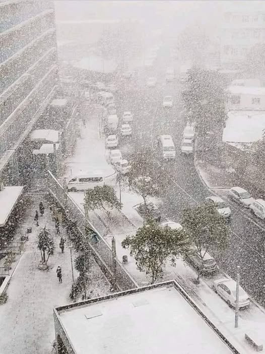
The arrival of snow isn’t an everyday occurrence for most of South Africa.

As we find ourselves back in snow season, we sat down with Vox Meteorologist Michelle du Plessis to give us the lowdown on how snow is formed.

And it turns out that, for snow to fall and reach the ground, three main weather conditions must come together.

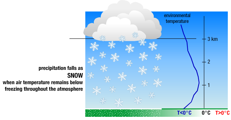
Cold air from top to bottom: The air must be below freezing (0 °C) all the way from the clouds to the ground. If there’s a warmer layer in between, the snow will melt and fall as rain or sleet. Ideal snow forms in clouds where temperatures are between -10 °C and -20 °C.

Enough moisture in the air: Cold air alone isn’t enough – you also need moisture so that water vapour can form ice crystals. Dry air, even if freezing, won’t produce snow.

Something to lift the air: Snow usually forms when air is forced to rise, cool, and condense. This can happen with cold fronts, low-pressure systems like cut-off lows, or when air is pushed up over mountains.

Gauteng’s last snowfall: July 2023…

In July 2023, Gauteng experienced rare snowfall – something locals hadn’t seen in over a decade (before 2023 it snowed in 2012 and 1996). While light snow sometimes falls in the province, heavier events like this happen only once every 10 to 20 years. So yes, it was unusual, but not unheard of.

The July 2023 cold snap wasn’t driven by climate change – instead, it was the result of a powerful cold front that swept across the entire country and extended into our neighbouring countries – supported by a steep upper-air trough, pushing icy air far north.

Looking ahead to winter 2025…

We find that the odds of another snowfall in Gauteng remain low. Climate trends suggest snow in the region will become even rarer in future. That said, nature still has surprises.

If the right weather patterns align—such as a strong cold front or cut-off low pressure system – we could see isolated snow again. But it would remain the exception, not the rule.