The 2025 / 2026 fires in the Western Cape, followed by the May 2026 floods, brought absolute devastation to some parts of the province, reminding us of the power of nature when it’s fully unleashed.

Vox Weather Meteorologists Annette Botha and Michelle du Plessis set out in the Subaru Crosstrek, in another episode of their ongoing quest to go ‘beyond the forecast’ – this time to find out more about the recent weather-related disasters. You can watch the video here – the visuals are a sober reminder of the power of nature.

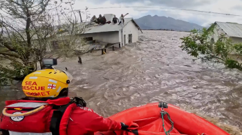
Both the Western Cape’s Provincial Government and its citizens are still recovering from the recent devastating fires and floods, which affected more than 231,000 people and severely damaged farms, roads and critical infrastructure. Sadly, some people also lost their lives during these extreme weather-related events.

Annette and Michelle decided to look at these two very different weather extremes: first came the intense fire season, which was then followed just a few months later by severe flooding. They set out in the Vox Weather Subaru Cross Trek to talk to some of the people who had experienced these weather extremes on the frontline.

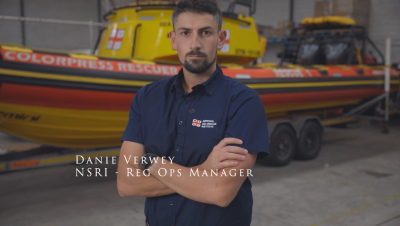
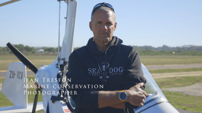
And so we hear from a helicopter pilot who spends most of his working life fighting fires from the sky; a marine conservation photographer who filmed some of the aftermath of the floods in a gyrocopter; and a regional operations manager for the National Sea Rescue Institute (NSRI), who was involved in some of the rescues during the flooding. Their stories, both individually and together, are inspirational and heart-warming.
Starting with the Fire Season

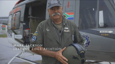
Hot, dry and windy conditions can very quickly turn a small fire into a deadly crisis. To understand what that looks like from the air, Annette and Michelle spoke to one of the fire pilots at Leading Edge Aviation, Mark Jackson, who runs the Lowveld-based company with his wife.

Mark explains: “We do a lot of aerial work, which includes some wildlife rescue work, but predominantly we’re involved in firefighting. For me, the defining feature of this recent fire season was how early and relentless it was. In 21 years of firefighting, I’ve never had to start so early.

“With the Gansbaai fires burning, our help was needed straight away. Working with our quick reaction force, we arranged to leave our normal base in the Lowveld and travel to the Western Cape to start suppressing those fires.

“From the first day, there were three solid ground teams, and the season never really slowed down from there.”
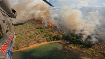
Mark clarifies that this fire season was more unpredictable and extreme than in recent years. He adds: “This was one of the busiest fire seasons I’ve seen. This was partly because we had very strong and warm berg winds. In this part of the country, they’re northerly winds that bring hot, dry air and this fire season, they were blowing at average speeds of around 40 to 50 kilometres an hour.

“These consistent winds were the strongest we’ve had in 30 years, and with winds like that, even the slightest ember or spot fire can blow up quickly, with the winds also, quite frequently, blowing all night. It helped to make the fire season unrelenting.”

Mark confirms that Leading Edge Aviation recorded 478 hours of firefighting and dropped about 8.2 million litres of water to quench the deadly fires.

He describes one particular moment that had an emotional impact on him, as follows: “We had a fire in the Wolseley–Tulbagh area that spread incredibly fast. It started next to a main road and was burning toward some wooden holiday cottages on flat ground. I circled overhead and signalled to the residents that the fire was coming. Watching people pack their belongings and leave in a hurry gave me goosebumps.

“We managed to put a line of water between the houses and the fire, and when we returned to refuel later, not one of those cottages had burned, and people were already putting their things back. It made the long distance we travel from home and the effort feel worthwhile!”
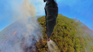
It’s incredible to think about the lives that Mark and his colleagues save – not only this year, but every fire season, due to the brave work they do in fighting the fires from the air.


From Dry Lands and Strong Winds to Saturated Grounds and Rising Rivers

After talking to Mark about the recent fires, Annette and Michelle then travelled in the Subaru Crosstrek to Morningstar Airfield near Cape Town to meet a pilot whose footage captured the flooding from the air.

Jean Tresfon is a marine conservation photographer, pilot and cameraman who flew over the flooded areas recently. He shot footage from a gyrocopter – a type of small aircraft used for surveillance and aerial photography – to document the aftermath, which helped many people to see exactly how serious the flooding was.

Jean explains: “The main day of flooding took place the day before I could fly. By the time I flew the following day, the water levels had dropped a little, which actually made the damage easier to see. Buildings that had been underwater were now exposed, and the damage was shocking, with farm fields plastered with mud, and infrastructure and many buildings heavily damaged or completely destroyed.”
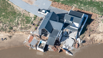
When comparing these floods to previous major Cape storms, Jean notes that, in terms of river height and the volume of water, this was the worst flooding since 1925. He says it’s plausible that the fire season contributed to the flooding, from the perspective of the fires burning through the vegetation that normally holds soil in place.

“When heavy rain falls soon after a fire, you get severe erosion. While the fires didn’t effectively contribute to the volume of water coming down the mountain, they certainly made the impacts worse, because vegetation and topsoil were washed away. For example, at Mitchell’s Pass near Ceres, the road was extensively damaged, with soil from burnt slopes coming down onto the road and nearby railway track, and so yes, in that sense, the recent fires played a role in the extent of the flooding.”
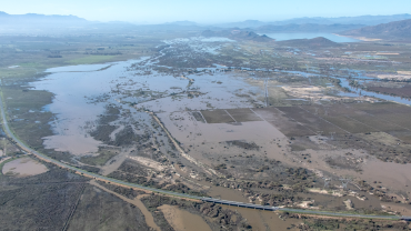
Jean notes that floods were common in the early 1900s and then rare for a while, and now we’ve seen notable events in 2008, 2023 and 2024, and again in 2026: “The pattern suggests these extremes are becoming more frequent, and the fires are definitely more prevalent than they used to be, and so preparation is more important than ever.”

It seems that we can’t pin a single storm or season directly on climate change, but we are seeing a more variable climate and more extreme events overall.


Rescue Operations During the Floods

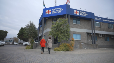
After listening to Jean’s information about the aerial views of the flooding, Annette and Michelle then went to the NSRI headquarters to learn more about how the recent flood rescue operations had unfolded on the ground. They spoke to Danie Verwey, who is one of the four regional operations managers for the National Sea Rescue Institute, and who reported that the rescue missions that took place were ‘hectic’.

Danie says: “After the heavy rainfall led to severe flooding across the Western Cape, volunteers and crews responded rapidly across multiple scenes. By the time we were activated, we already had several stations responding to call-outs throughout the day.

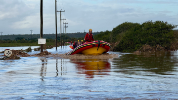
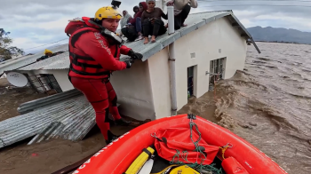
“One of the incidents people saw on social media was around Station 42, Kleinmond, responding in the Worcester and Rawsonville areas. The rescue crews really had to improvise: they couldn’t always reach casualties with boats, so they used anything they could find, including ladders, floating debris or anything that would get them to people stranded on roofs.”

Danie says there are many stories that stand out. “For example, in one case, crews scoped a house to see if anyone was trapped inside. They climbed onto the roof but couldn’t access the house through doors or windows because of the water, so they removed corrugated sheeting to enter from above.”

This kind of improvisation and bravery was common. If there is one main safety lesson for the public to learn from this event, it’s that if local authorities ask you to evacuate, you really should do so if you can!

Danie continues: “We know it’s not simple, and that you can’t always pack everything you love, but leaving when you’re advised to do so is usually the safest option. If you can’t reach higher ground, try at least to move out of the most affected area. Also, if you do evacuate, stick together in a group; it’s far easier for rescue teams to find groups than individuals.”
Annette notes: “From fire to flood, this all shows how quickly weather risks can change and how deeply they can affect lives, livelihoods and communities. That’s why we don’t stop at the forecast but instead aim to go beyond the forecast.”

Michelle concludes: “And from dry lands and strong winds, to flying over flooded fields and facilitating rescue missions, that’s another report from us on the harsh realities that the weather can help to unfold. We are thankful to Mark, Jean and Danie for sharing their experiences with us, as well as the incredible work that each of them does to share information and help to save lives.”
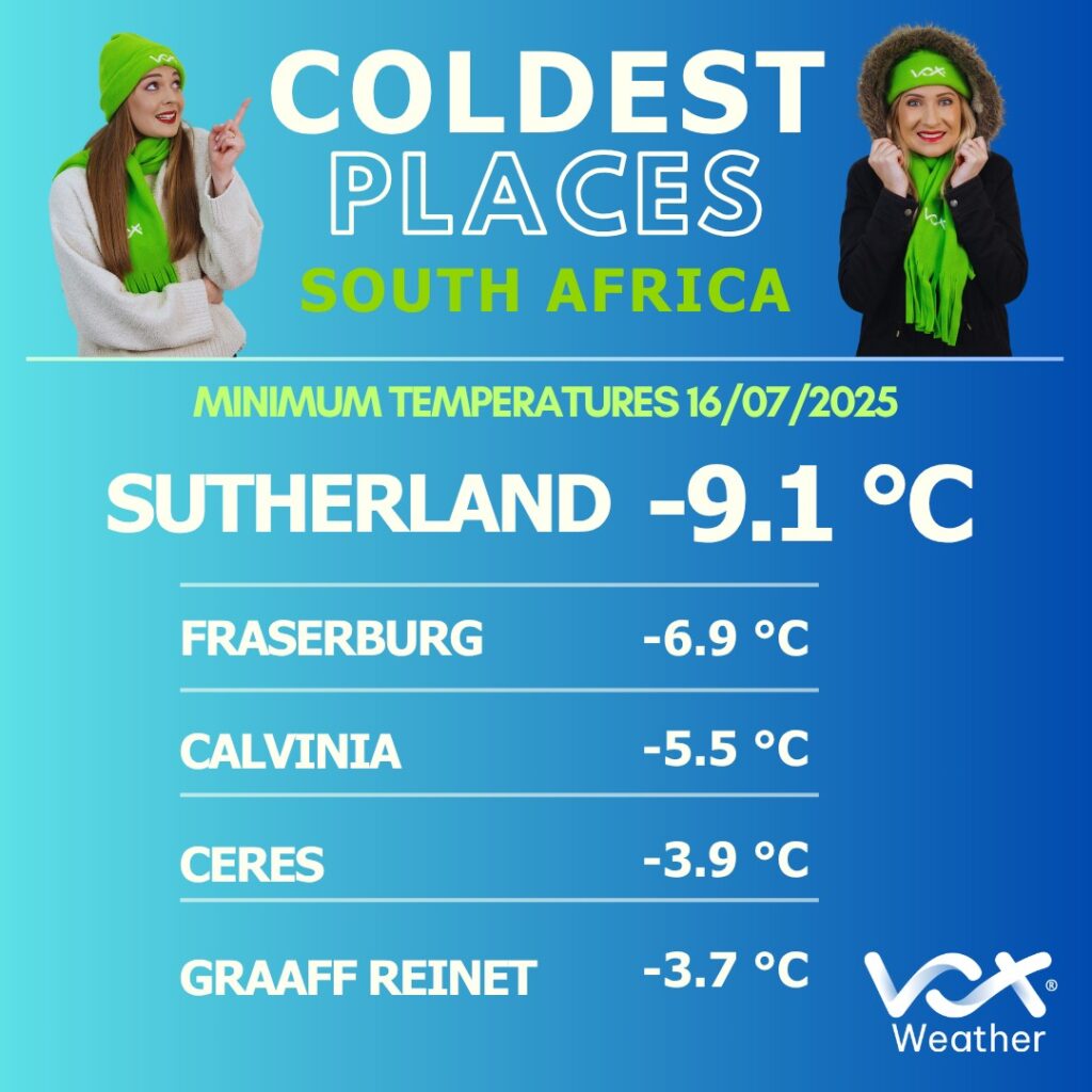
Winter in South Africa runs officially from the beginning of June to the end of August – that is, from a meteorologist’s point of view. So even if we get icy weather in May, we’re still only ‘officially’ in Autumn! Meteorological seasons are based on calendar months and average annual temperature cycles, making them more consistent for record-keeping and climate analysis.

And so, as we move towards mid-July and the halfway mark of winter, Vox Weather Meteorologist Michelle du Plessis gives us an update on winter so far, and what the coming months might bring.

June Rainfall and Temperature Patterns

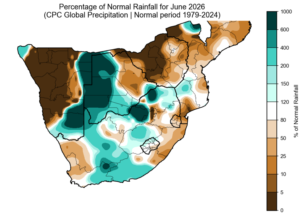
June rainfall anomalies show that some seasonal models correctly picked up on the drier start to winter over the far west. However, June was not dry everywhere. More than one cut-off low system brought above-normal rainfall to parts of the summer rainfall region and the Southern Cape. Southern Namibia also stood out, with some areas receiving up to six times their normal monthly rainfall.

Although it may have felt cold at times, June was surprisingly warm overall. Across large parts of South Africa, both morning and daytime temperatures were above normal. Provincial temperature analysis shows that the Free State, North West, Northern Cape and KwaZulu-Natal recorded their warmest average June temperatures since 1979, and possibly their warmest June on record.

El Niño Is Here

El Niño is currently one of the biggest talking points in weather and agriculture. But it is important to remember that El Niño is not something that will suddenly ‘hit’ South Africa – it has already started developing over the Pacific Ocean.

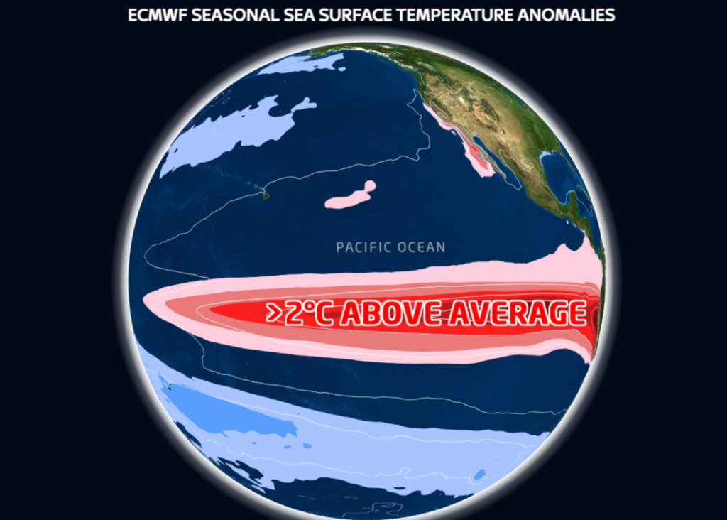
We are currently in weak El Niño conditions, meaning sea surface temperatures over the central and eastern Pacific Ocean are warmer than normal. El Niño is expected to continue through winter and spring, with an 81% chance of developing into a very strong event during October to December 2026. This would rank it among the largest El Niño events in the historical record dating back to 1950.

A very strong, or so-called ‘super’ El Niño, usually refers to an event where sea surface temperatures across large parts of the central and eastern Pacific remain more than 2°C above normal for an extended period.

Does A Strong El Niño Always Mean Drought?

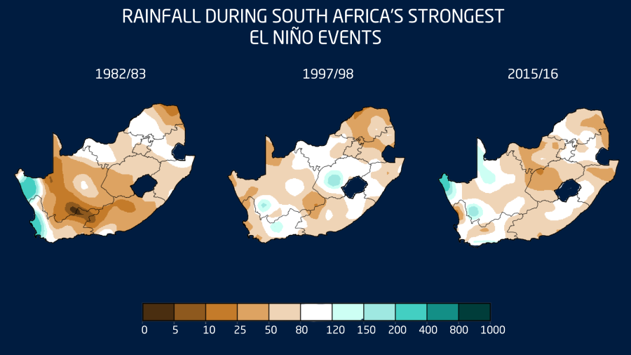
No. South Africa has experienced strong El Niño events before, and they have not all produced the same outcome. During strong El Niño events in the 1980s and 1990s, many areas did experience drier-than-normal conditions, especially over the summer rainfall region. However, there were also parts of the country that still received normal or even above-normal rainfall, including parts of North West and the Free State during the 1997/1998 summer.

The major exception was 2015/2016. That was one of the strongest El Niño events on record and contributed to one of the worst droughts in modern South African history.

The key message is this: a strong El Niño does not guarantee drought. It increases the risk of drier-than-normal conditions, especially over the summer rainfall region.

A Better Starting Point Than 2015/2016

There is also some good news. Many dams are currently in a healthy state, and soil moisture looks better over large parts of the country than it did before the 2015/2016 drought.

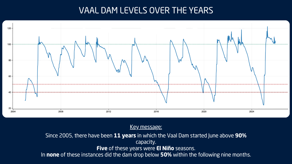
The Vaal Dam is a good example. Since 2004, there have been 11 years where the Vaal Dam started June above 90% full, similar to this year. In all 11 of those years, the dam remained above 50% for the following nine months. Five of those years were El Niño seasons, including 2018 and 2023.

This does not mean we can relax, but it does give South Africa a stronger starting point if the coming summer does turn warmer and drier.

Seasonal Outlook: Winter Into Spring

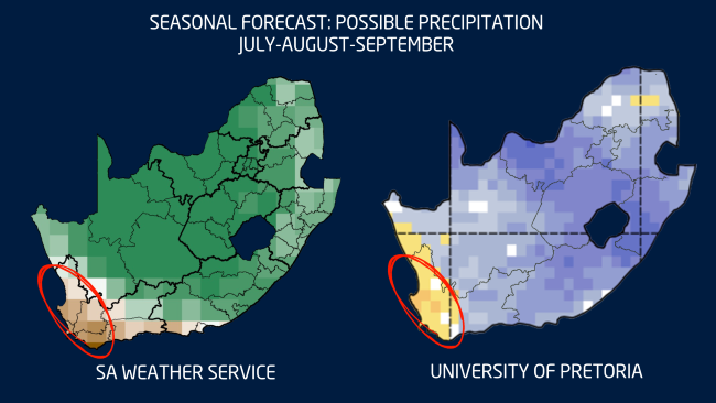
Looking at the rest of winter and the start of spring, both the SA Weather Service and University of Pretoria forecasts agree broadly on one thing: the far west is likely to remain drier than normal.

There are still indications of above-normal rainfall over parts of the interior, especially where cut-off lows or upper-air low-pressure systems may develop. This is a pattern we started seeing in June already, with weaker cold fronts over the Western Cape and more active upper-air systems over the interior.

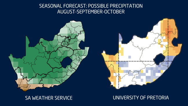
By late winter and early spring, the models begin to differ more noticeably. The SA Weather Service shows a possible wetter-than-normal signal over parts of the interior, while the University of Pretoria forecast is more mixed and even shows a drier signal in some areas.

This difference highlights the uncertainty that still remains. The atmosphere has not yet fully decided how it will respond to the developing El Niño.

Summer Outlook: Heat May Be the Bigger Risk

While below-normal rainfall remains an important risk, the biggest concern this summer may not only be drought, but extreme heat.

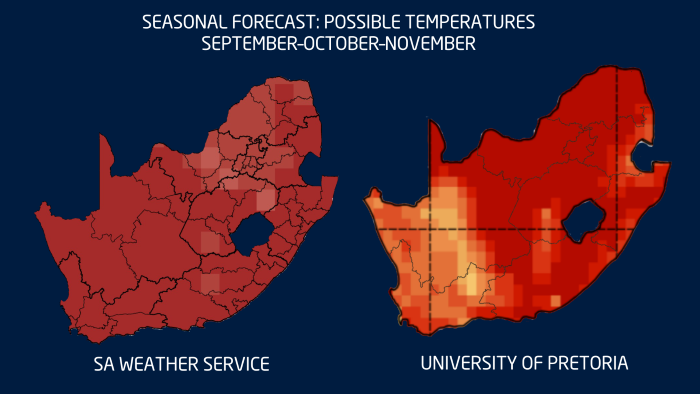
Most seasonal forecasts agree that South Africa can expect warmer-than-normal conditions from spring. This increases the chance of more frequent, longer and more intense heatwaves during the coming summer.

Higher temperatures also mean higher evaporation, increased water demand for crops and livestock, and greater pressure on soil moisture. When thunderstorms do develop, the extra heat and moisture can also help fuel more intense, isolated storms. So even in a season with a drier overall signal, heavy downpours, hail and localised flooding can still occur.

What Should Farmers and the Public Take from This?

  • Do not rely on one seasonal forecast alone. Seasonal forecasts give us an indication of the most likely scenario, but they are not exact predictions of what will happen on every farm.
  • Plan for a warmer-than-normal summer. This is currently the clearest signal across most climate models. Higher temperatures can increase water demand and heat stress for both crops and livestock.
  • Prepare for both extremes. A strong El Niño increases the risk of a drier summer, but it does not mean there will be no rain or storms. When the right conditions develop, thunderstorms can still become severe.
  • The good news is that there is still time. El Niño develops over months, not days. Regular monitoring, good planning and the use of short-term forecasts remain the best ways to manage risk.

We publish a new seasonal outlook every month on Landbou.com. Keep monitoring the latest forecasts, share this information with other farmers, family and friends, and use the time now to prepare for what the summer may bring.


When you look at recent weather maps of South Africa, you could be forgiven for thinking that we are living in two different countries. Vox Weather Meteorologist Michelle du Plessis shares the first seasonal outlook of 2026.

Please note: All graphs and images are taken from the latest Langtermyn Landbou-Weervoorspelling, and the text on the visuals is in Afrikaans. You can also view the Landbou show here.

The first agricultural weather outlook of 2026 begins with a country already deeply shaped by summer weather extremes. While large parts of South Africa experienced intense thunderstorms, flooding and high humidity in December, the western regions faced the opposite: extreme heat, dryness and severe fire danger.

The key question now is whether December was just a noisy outlier, or whether it signals a broader pattern for the rest of summer and early autumn.

December 2025: A month of extremes

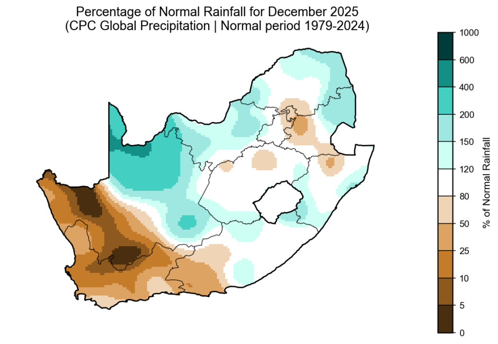
According to the CPC percent-of-normal rainfall map for December 2025 (based on the 1979–2024 climate period), a classic summer contrast emerged across the country.

The northern, central and eastern regions recorded above-normal rainfall, while the south-western and western areas — particularly the Western Cape, southern Cape and parts of the Northern Cape — were much drier than normal.

Although the Western Cape normally receives most of its rainfall in winter, 2025 was exceptionally dry. It now ranks among the three driest years of the past four decades for the province.

Severe convective storms in the north and east

The above-normal rainfall across the summer-rainfall region was driven by powerful cumulonimbus thunderstorms. These towering cloud systems are responsible for lightning, hail, intense downpours and flash flooding.

Large parts of the northern and eastern provinces saw repeated thunderstorm outbreaks. A particularly shocking event occurred in the Majaneng area near Hammanskraal, where reports indicated that around 40 people were struck by lightning around 3 January.

Several storms also produced large hail, causing localised agricultural and property damage. Flooding was widespread in areas where storms repeatedly tracked over the same catchments.

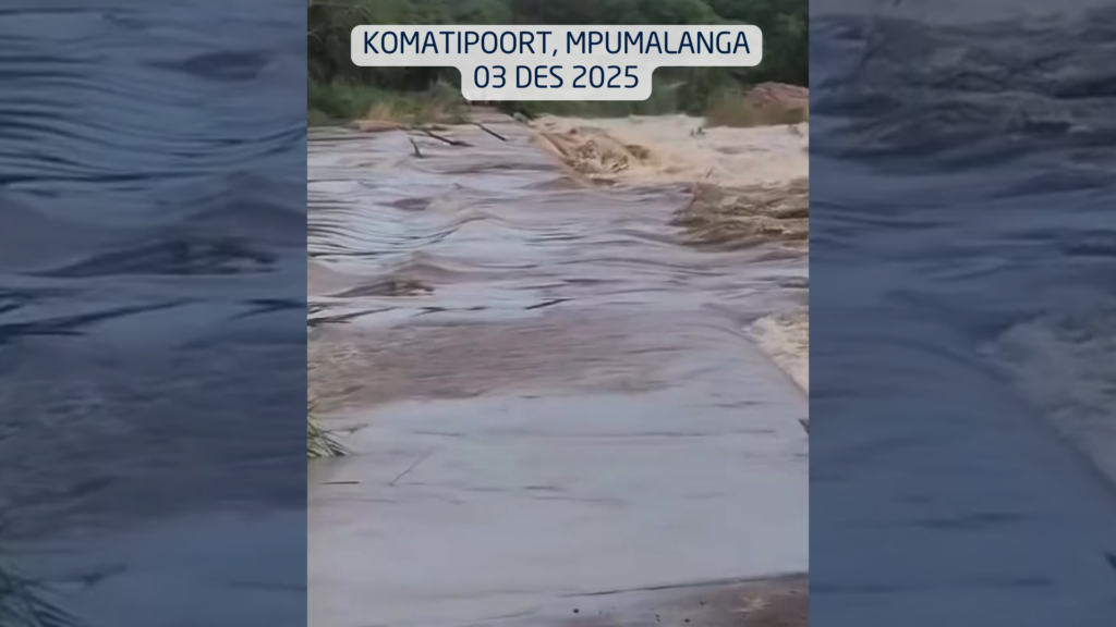
In the Lowveld, impacts became severe. On 3 December, a vehicle carrying eight people was swept away at the Komatipoort low-water bridge by the swollen Nkomazi River, highlighting how deadly summer river crossings can become.

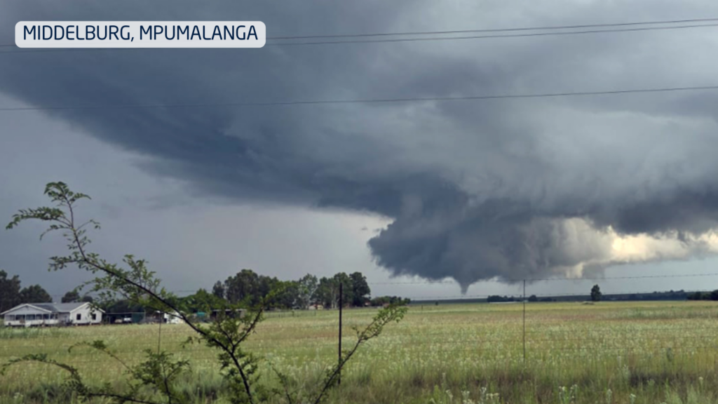
On New Year’s Day, two tornadoes were confirmed in Mpumalanga, near Middelburg and Carolina, causing damage to buildings and infrastructure.

Extreme fire season in the west

While storms dominated the east, the western parts of the country endured heat, strong winds and very little meaningful rainfall. This combination triggered one of the most severe fire seasons in years.

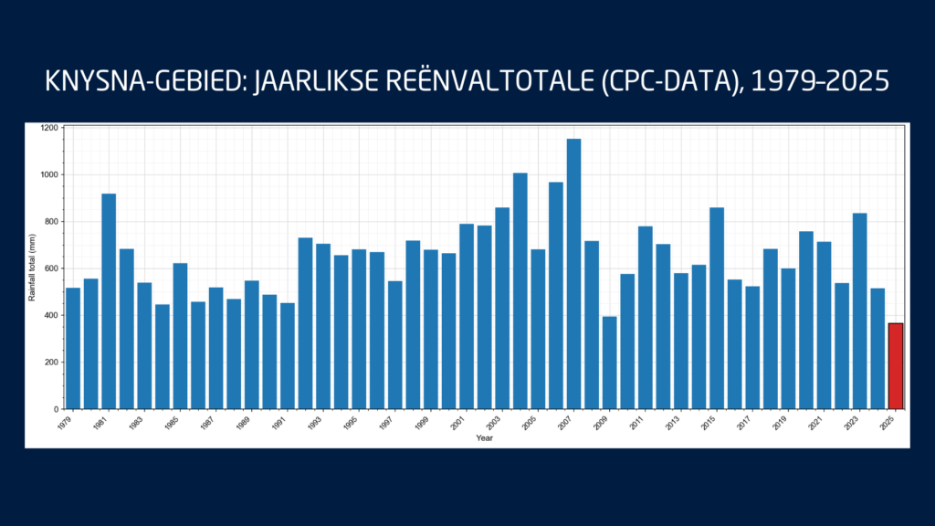
These fires occurred while the southern Cape was already under severe water stress. Knysna entered Level 4 water restrictions, with only days of usable water left in the Akkerkloof Dam. Rainfall records show that 2025 was the driest year in over 40 years for the area, pushing the town dangerously close to so-called Day Zero.

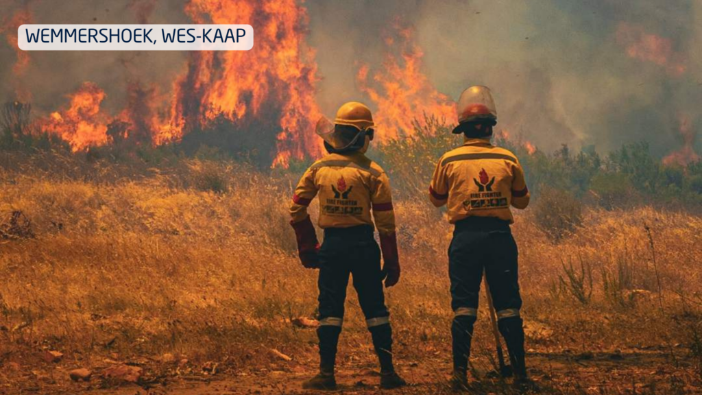
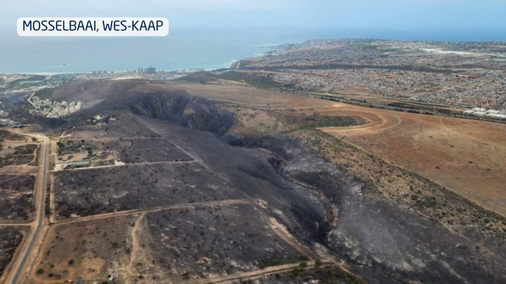
Disaster management confirmed that at least 10 major wildfires burned over a single intense week, destroying approximately 90,000 hectares and damaging dozens of structures.

What ENSO is telling us

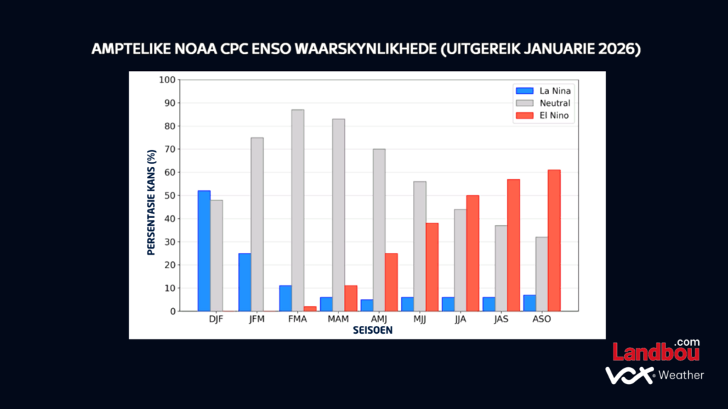
The latest ENSO indicators continue to show La Niña conditions persisting through the rest of summer. These are expected to weaken into neutral conditions during autumn, while the probability of El Niño increases toward late winter and early spring.

For agriculture, this suggests:

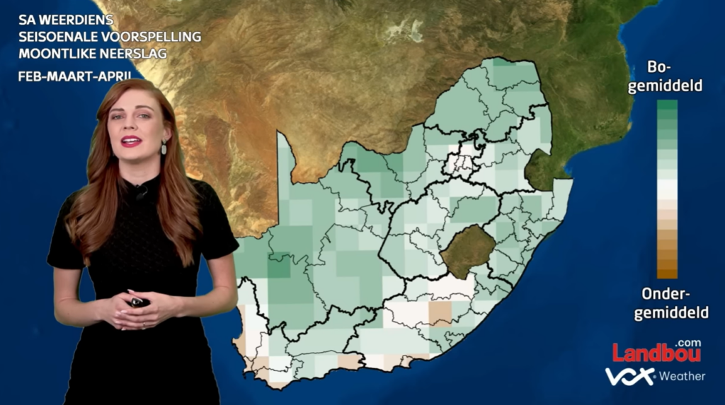
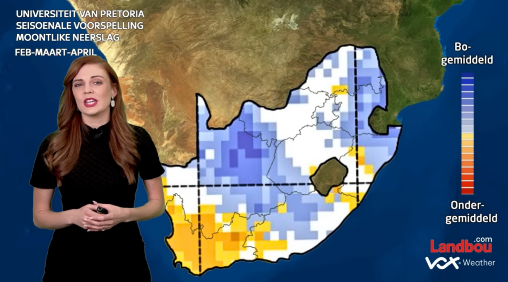
  • Above-normal rainfall risks continue in the east during late summer
  • More variable conditions into autumn
  • A growing risk of warmer and drier conditions later in the year as El Niño develops

Water resources under pressure

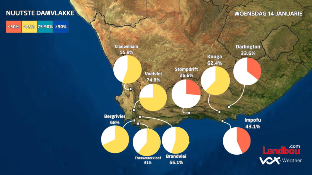
The Western Cape’s dam levels currently average 66.3%, down sharply from 86.5% at the same time last year. This significant drop highlights how vulnerable the region already is before the winter rainfall season even begins.

In the Eastern Cape, dam levels also remain below last year’s levels, averaging 75.4% compared to 81.3% a year ago. Although the Eastern Cape forms part of South Africa’s year-round rainfall zone, this does not mean rainfall is evenly distributed. Over recent months, most of the rain has fallen further north and east, with major systems missing much of the southern and eastern Cape. This explains why, despite its climate, the region is still under water pressure.

What this means for the months ahead

December was not an isolated event. It reflects a broader climate pattern of:

  • Wet, storm-prone conditions in the east
  • Hot, dry and fire-prone conditions in the west
  • The seasonal outlook suggests this contrast is likely to persist through late summer and early autumn.

For farmers, this means that in the east and Lowveld, there is continued risk of flooding, crop disease and soil erosion; while in the west, there will be ongoing pressure on water resources, fire management and drought planning.

Seasonal models cannot predict individual storms, but they do provide reliable guidance on overall trends. And the trend for early 2026 is already clear:
A wet east, a dry west, and significant agricultural challenges across both.

Vox Weather Meteorologist Annette Botha gives us the details on the 2025 / 2026 summer season – looking back on some of the drama that the weather has recently thrown at us, and what we can expect going into next year.

You can also click here to see Annette presenting this information in a short video in Afrikaans, as part of the regular ‘Langtermyn Landbou-Weervoorspelling’ series, and experience some spectacular additional video footage of recent weather-related visuals that are highlighted here.


South Africans have just come through one of the most dramatic Novembers in recent years – it was a month marked by relentless thunderstorms in the north and east, with widespread hail, local flooding, and strong winds in the Western Cape.

Now, as we turn the corner into December, the latest seasonal forecasts point to a summer of strong contrasts: wet, stormy and cooler in the east, but hot, windy and fire-prone in the west.

A Record-Breaking End to Spring

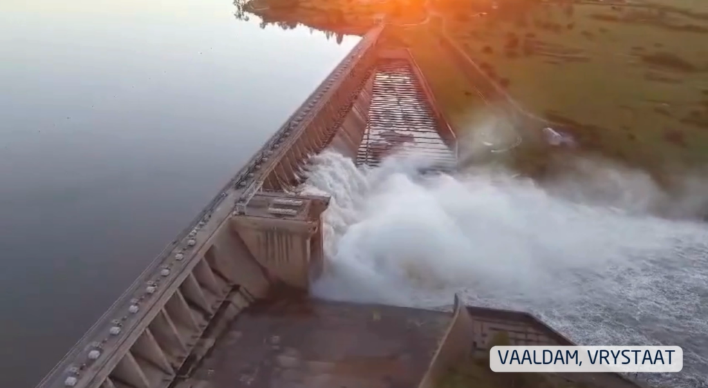
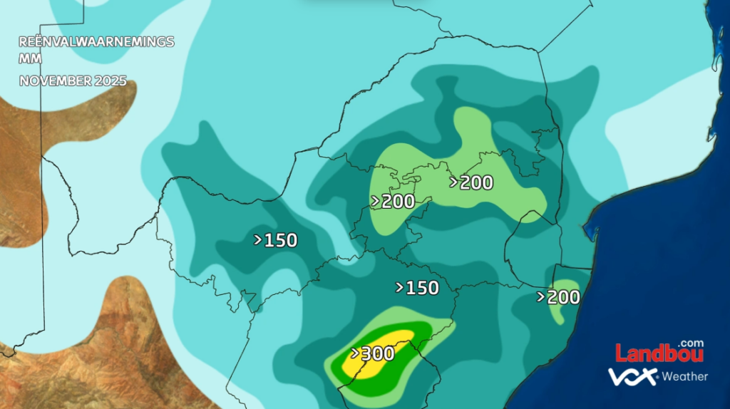
November delivered an onslaught of thunderstorms across Gauteng, Limpopo, North West, the Free State and the drought-stricken Eastern Cape. Many large dams responded quickly: the Vaal, Gariep and Bloemhof Dams rose sharply, with several spilling over.

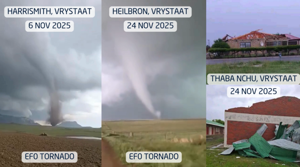
Thunderstorms were fuelled by unstable, moisture-rich tropical air that repeatedly surged across the interior. More than one EF0 tornado was reported in parts of the Free State, a reminder that South Africa’s ‘tornado corridor’ can produce short-lived but destructive events almost every summer.

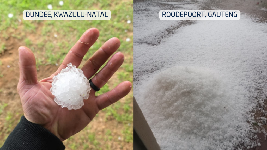
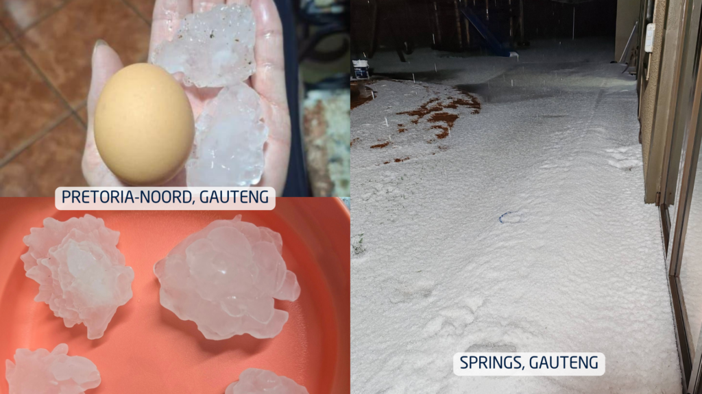
Hail was another standout feature of the month. In some towns, small hail accumulated so thickly that streets resembled winter scenes, trapping cars and residents. In other areas, hail the size of chicken eggs caused extensive damage to vehicles, roofs, gardens and crops. Farmers across the Free State and neighbouring regions faced the difficult balance of ‘good rain, but big losses’.

Meanwhile, in dramatic contrast, the Western Cape battled powerful southeasterly winds, fanning multiple wildfires across the Cape metro and agricultural zones. Homes were evacuated and producers faced early-season challenges with wind damage, low soil moisture, and fire risk.

How Much Rain Actually Fell?

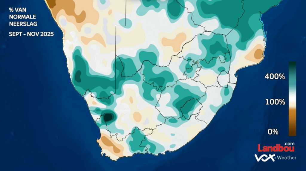
November did not just feel wet, it was exceptional. Large areas of the summer rainfall region recorded more than 150mm for the month, with pockets exceeding 200mm. To put this into perspective: Pretoria’s long-term November average is around 90 mm. Many regions received more than double their normal rainfall.

While the interior soaked, the Karoo, Eastern Cape and Western Cape experienced a notably drier spring, aligned with the persistent windier pattern that dominated the southwest.

December Wind Outlook: More Gusts on the Way

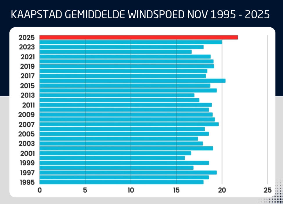
November 2025 was confirmed as the windiest November since 1995 over the Western Cape based on 30-year wind-speed averages.

Unfortunately for Capetonians, the models show continued above-normal windiness in December.

This raises wildfire danger even further heading into the heart of the festive season.


Dams, Climate Drivers and What is Shaping the Season

Dam levels remain high across the interior and are expected to climb further with continued rainfall. In contrast, dams in the Western and Southern Cape are dropping quickly, with some municipalities already preparing for potential water restrictions.

Globally, the climate system is reinforcing the wet-summer signal. We remain in La Niña conditions, and the Indian Ocean Dipole (IOD) is in a negative phase, a combination that historically supports above-normal summer rainfall for South Africa’s summer rainfall belt.

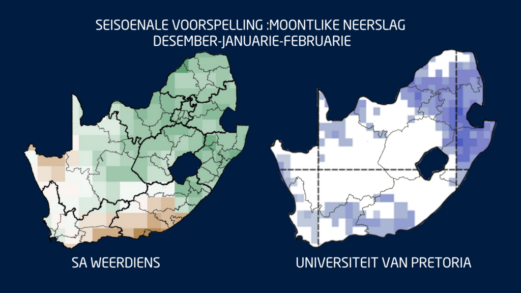
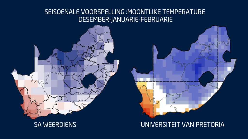
This means that December through February (DJF) still shows strong model agreement: a wetter-than-normal summer across the central and eastern parts of South Africa.

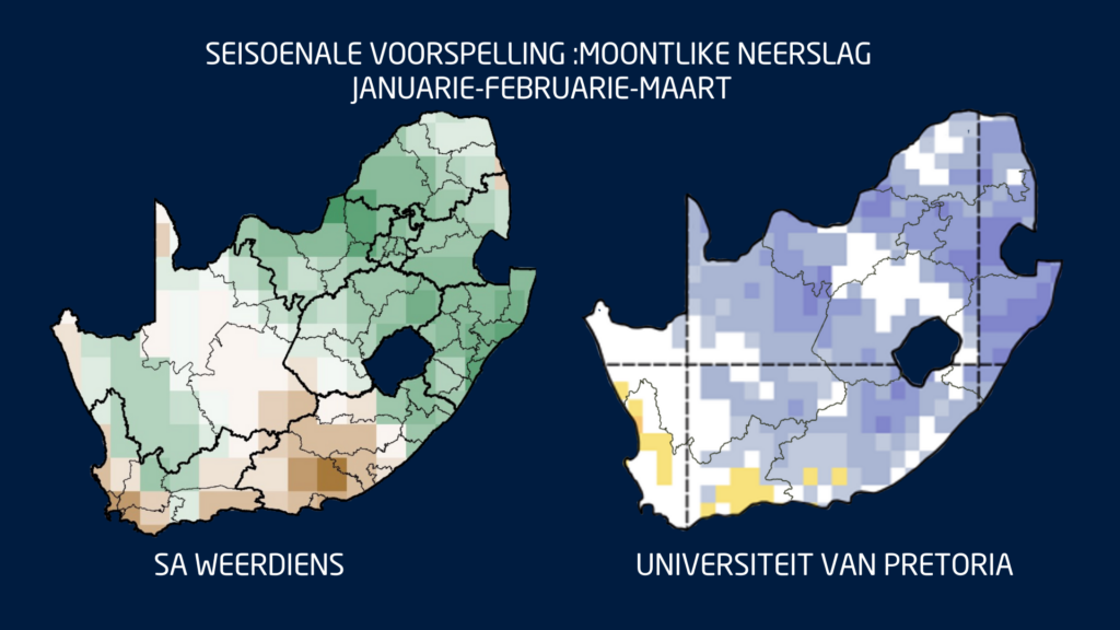
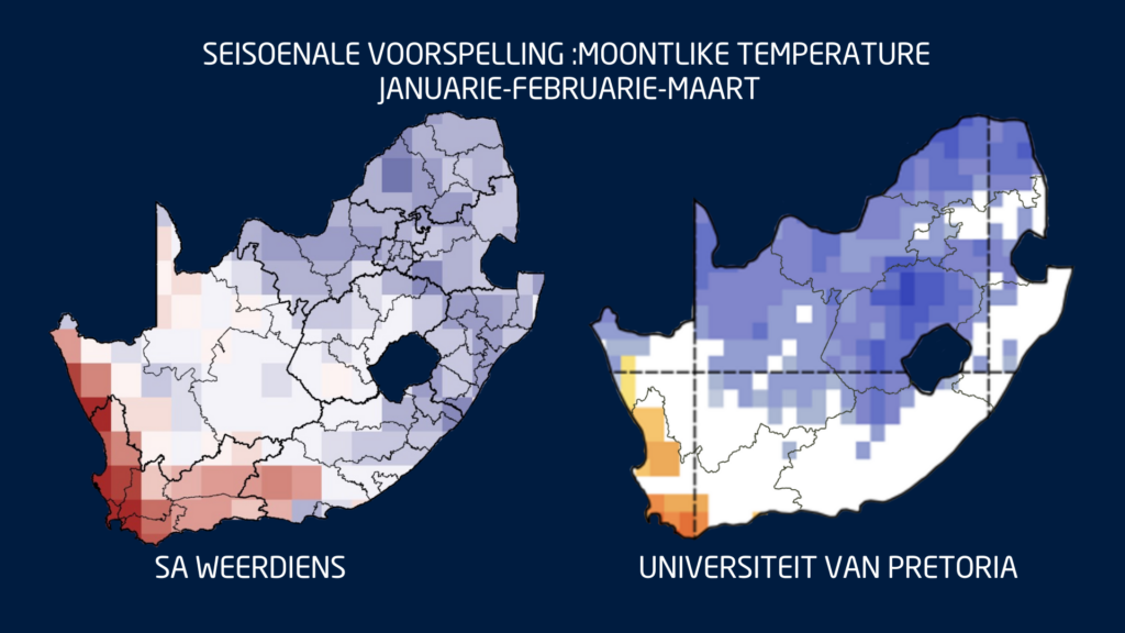
The only region where uncertainty remains is the Eastern Cape, ironically one of the provinces most in need of sustained rain. Seasonal guidance for January to March (JFM) keeps the same pattern: above-normal rainfall inland, with drier-than-normal tendencies persisting over parts of the Southern Cape.

Temperatures: Cool in the East, Very Hot in the West

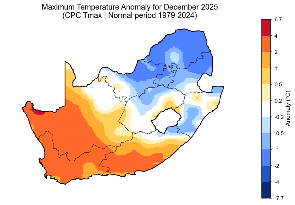
Where rainfall increases, maximum temperatures are expected to trend lower. Much of the summer rainfall region may see cooler-than-normal daytime temperatures through summer and early autumn.

However, the Western Cape, Northern Cape and Namakwa can expect very hot, windy conditions, especially toward the end of summer and into early autumn, a period when fire danger typically peaks.


What to Expect Week to Week

Short-term and sub seasonal models show a continued pattern of:

  • Repeated thunderstorm activity over the central and eastern interior;
  • Occasional heavy rain and local flooding;
  • Persistently gusty southeasterly winds in the southwest; and
  • Episodic heatwaves in the western interior

Farmers, disaster managers and residents should prepare for a summer with sharp contrasts: regular storms and good rain inland, and ongoing heat and fire risk in the west.

And finally a quick note to close off the year:

The Vox Weather ladies will be on annual leave for the festive season, but Vox Weather followers will still receive the daily weather maps throughout the period.

And so from Annette and Michelle: Wishing you a wonderful holiday period – travel safely and know that Vox Weather is always here to help you with your planning and continue ‘putting the WE back into Weather’!

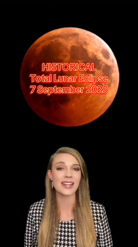
This is a celestial event you won’t want to miss — and one of the best lunar eclipses visible from South Africa in years.

Stargazers around the country have been waiting impatiently for a stunning astronomical spectacle that’s taking place on the night of Sunday the 7th of September 2025, when a rare total lunar eclipse, commonly called a Blood Moon, will be visible across the country. Grab your warm jackets (it can still be cold during September evenings) and get comfortable as the sky puts on an amazing show!

Vox Weather Meteorologist Michelle du Plessis tells us more about how lunar eclipses are formed, and the weather we can hope for on Sunday night.

What is a Lunar Eclipse?

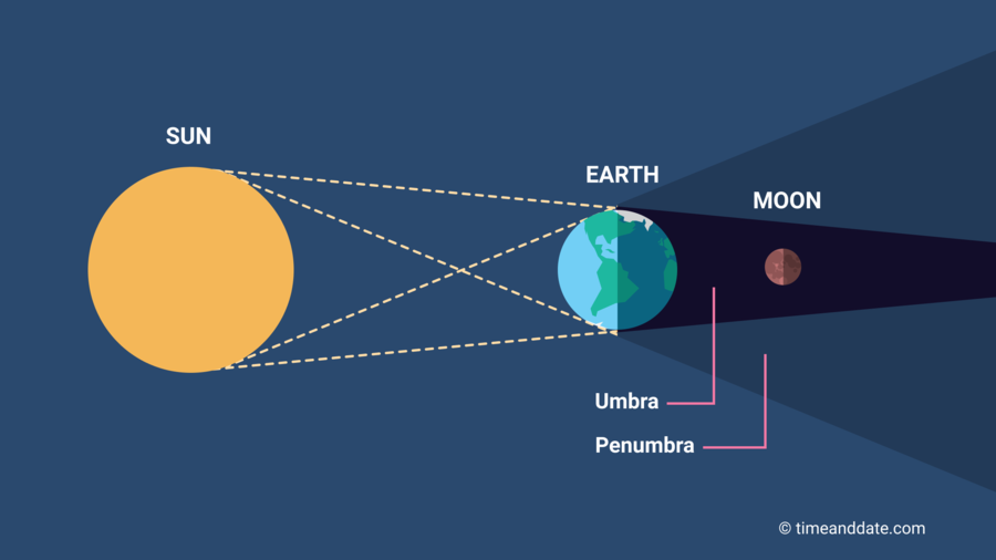
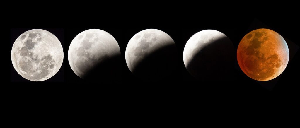
A lunar eclipse happens when the Earth passes directly between the Sun and the Moon, casting its shadow onto the Moon. This only occurs during a full moon.

There are three types of lunar eclipses:

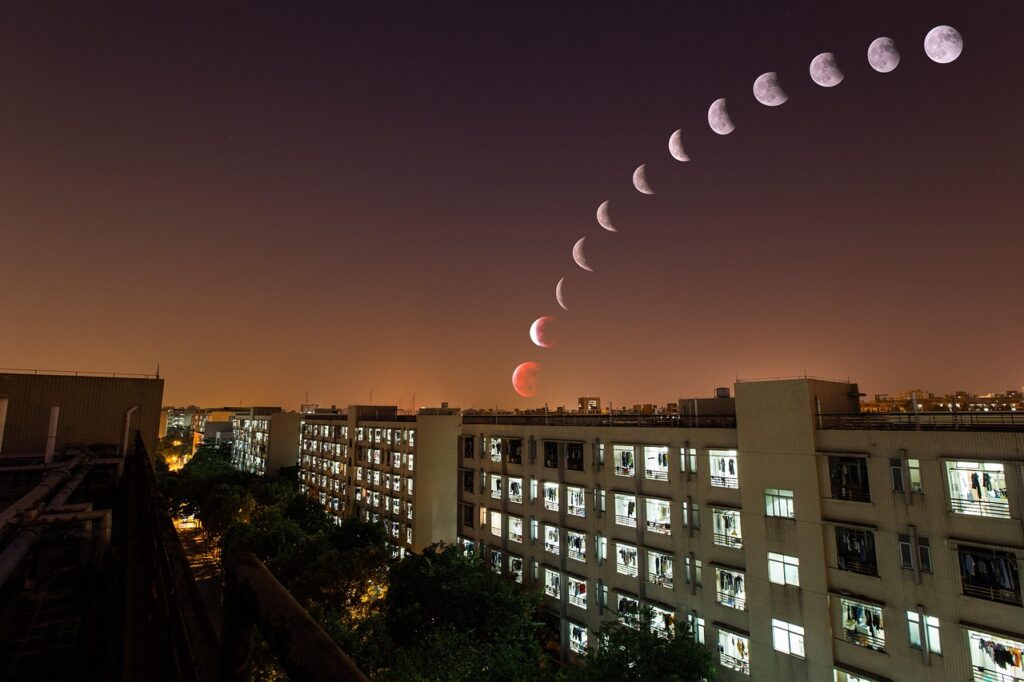
  1. Penumbral Lunar Eclipse – the Moon passes through Earth’s faint outer shadow (the penumbra), causing only a slight dimming.
  2. Partial Lunar Eclipse – part of the Moon passes through Earth’s dark central shadow (the umbra), and a section appears darkened.
  3. Total Lunar Eclipse – the entire Moon moves into Earth’s umbra, turning a reddish colour — often called a ‘Blood Moon’.


During a total lunar eclipse, the Earth blocks direct sunlight from reaching the Moon. However, sunlight still filters through Earth’s atmosphere and bends (or refracts) around the planet.

Shorter blue wavelengths are scattered, and the longer red and orange wavelengths reach the Moon — causing it to glow red or copper.

It’s the same effect that gives us red sunrises and sunsets — except this time, you’re seeing it reflected back from the Moon!

This TikTok video from Michelle shows us more on how lunar eclipses take place – together with a quick weather overview for the country’s stargazing.

The 7 September 2025 eclipse is special because:

  • It will be a total lunar eclipse, with the entire Moon turning red.
  • It will last 82 minutes, making it one of the longest lunar eclipses of the decade.
  • It will be visible across South Africa.
  • No telescope is needed — you can see it with the naked eye if skies are clear.

South Africa Viewing Details and Weather Conditions

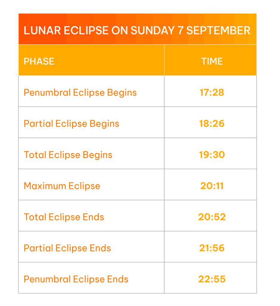
The table shows the key moments to look out for. The best time to watch is between 7:30 PM and 8:52 PM, when the Moon will be completely within Earth’s shadow and glowing red.

The weather conditions for 7 September across the country will be mostly favourable for viewing the total lunar eclipse on Sunday evening.

  • However, around the Southern Cape, including parts of the Garden Route and Overberg, we are expecting widespread cloud cover, which will most likely obscure the view of the eclipse.
  • In contrast, much of the interior, including the Free State, North West, Limpopo, and Gauteng, will experience partly cloudy skies with high to mid-level cloud, allowing for intermittent but generally good visibility of the eclipse.
  • Cape Town is also expected to have clear enough skies, especially earlier in the evening, making for a great viewing opportunity.
  • Coastal areas in KwaZulu-Natal and parts of the Eastern Cape may see some coastal cloud or mist, especially early evening, but breaks in the cloud are possible later on.

For the best view, try to find an open area away from city lights — ideally elevated, with an unobstructed view of the eastern horizon where the Moon will rise.

Tips for Watching and Photographing

  • Dress warmly — it’s still chilly at night in September.
  • Use a camera with manual exposure settings if possible.
  • For smartphone users: Tap to focus on the Moon and reduce brightness for better contrast.


Fun Facts

  • A lunar eclipse can only occur during a full moon.
  • Unlike a solar eclipse, lunar eclipses are safe to view with the naked eye.
  • The Moon doesn’t completely disappear — it turns red due to Rayleigh scattering in Earth’s atmosphere.

Why Is It Called a “Blood Moon”?

The term ‘Blood Moon’ comes from the deep red colour the Moon takes on during totality. Ancient cultures often saw it as an omen, but today we know it’s simply the effect of Earth’s atmosphere bending sunlight.

Mark your calendars and if skies are clear, look up and enjoy the show!

What is happening to SA’s winters and is climate change playing a significant role? Vox Meteorologist Michelle du Plessis tells us more.

Data shows that winter temperatures across southern Africa have been steadily rising since the 1960s, with fewer days of frost and freezing conditions.

According to the NOAA, extreme cold events are now far less common – and when they do happen, they’re generally milder than in the past.

In the Western Cape, where winter rainfall is vital, climate models show that the rainy season is becoming shorter and more variable.

While some winters still bring strong cold fronts and good rainfall, others are marked by long dry spells.

The WMO warns that drought risks are increasing, especially in Mediterranean-type climates like the south-western Cape.

Interestingly, while total rainfall may decrease, when storms do occur, they may be more intense – bringing short bursts of heavy rain rather than steady soaking periods. This is because warmer air holds more moisture, which can lead to more powerful frontal systems when they develop.

Recent studies suggest that mid-latitude frontal systems – the cold fronts that bring winter rain – may grow stronger under climate change. However, this doesn’t mean we’ll get more of them. Instead, we may see fewer, but more intense, winter storms, followed by longer dry periods in between.

What this means for South Africa

In short, South African winters are becoming:

  • Warmer, with fewer frost days;
  • More variable, with rain falling in short, intense bursts; and
  • Less predictable, meaning long-range planning is harder.

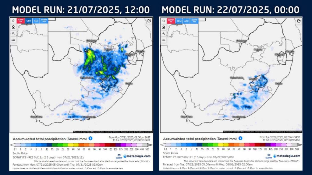
Some early snow forecasts recently circulated on social media suggested possible snowfall over parts of Gauteng, North West, the Highveld, and other areas that rarely experience snow during late July. At Vox Weather, we chose not to post about these projections – and here’s why.

Advanced snow forecasts, particularly more than five days ahead, are often subject to significant change. In fact, updated model guidance today NO LONGER indicates snowfall over these north-eastern regions at all.

Our approach as meteorologists to snow forecasting involves more than just looking at model snowfall outputs.

We analyse:

  • The SYNOPTIC SYSTEM expected (e.g. a cold front or cut-off low);
  • The availability and timing of PRECIPITATION; and
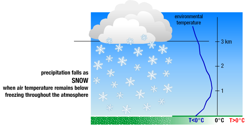
  • The FREEZING LEVELS (the altitude at which temperatures are cold enough for snow to form and reach the ground).

These factors must all align for snowfall to be possible. A shift in any of them can lead to significant changes in where snow may fall – or if it occurs at all.

As of the latest forecast, we see:

  • A cold front expected to move in on Friday 25 July.
  • A strong ridging high-pressure system to follow, introducing colder air over southern South Africa during the weekend of 26 and 27 July.
  • Forecast snowfall now largely restricted to the Eastern Cape, Lesotho, the southern Free State, and adjacent high-lying areas.

At Vox Weather, we prefer to wait until we see consistency in multiple forecast runs – usually within a five-day window – before communicating potential snowfall.


This ensures that our updates are as accurate and reliable as possible.

As Winter 2025 tightens its grip, more and more viewers are tuning in every day to the skilled presentation and deep expertise of Vox Weather’s popular Meteorologists, Annette Botha and Michelle du Plessis.

Vox Weather, which was launched and managed by telecommunications and IT services provider Vox, is now proudly on the peak of reaching 500,000 followers as South Africans across the country rediscover the joys of a daily weather update that’s presented with flair and style.

So it’s “Goodbye app…” and hello to “No matter the weather, we’re in this together!” as we tune into the daily weather news.

The first significant milestone was reached when Vox Weather grew to 50,000 followers within the first six months of launching in late 2021. After this, the platform took just another year to double up to 100,000 dedicated followers, and a reach of close to two million people per month, on average, in its first 18 months. Now, in mid-2025, Vox Weather is on the bridge of crossing the half a million mark – groundbreaking and impressive indeed.

But what is making the Vox Weather channel so successful? There are probably multiple reasons for this, but Vox Social Media Specialist Lynelle Davids, who tracks the Vox Weather statistics regularly, has some ideas. 

“For starters,” she says, “it helps that the weather is presented by two living, breathing rays of sunshine… but seriously, there are indeed multiple reasons for the growth. Besides the interesting content – the weather is important to everyone! – the animated graphics are modern and eye catching, but also easy to understand. There is, of course, serious technology behind each graphic that they share.

“Annette and Michelle are both highly qualified scientists, bringing credibility to their weather presentations – they really understand what they are telling the viewers; in fact, they prepare the visuals themselves from the raw data.

And Vox Weather makes excellent use of available social media platforms to actively market its content. This includes sharing different types of information across the channel’s home web page as well as Facebook, YouTube, X, Instagram, WhatsApp  and LinkedIn.”

Annette says: “We are so humbled to have achieved this important milestone of 500,000 followers, and appreciate the time and trust our audience has placed in us by regularly tuning in across the various platforms for the latest updates. As we like to say: it’s all about putting the ‘WE’ back into weather!”

Michelle adds: “It’s a joy and an honour to deliver a presenter-led weather report, together with animated graphics. It’s our belief that this truly helps to bring the weather to life with a real personal touch.”


According to Lynelle, there have been some interesting additional milestones achieved lately for Vox Weather’s social media numbers.

“We recently saw an incredible spike in followers on Facebook,” she clarifies, “when Annette and Michelle gained 5,300 new followers in two days! And WhatsApp saw the same spike with 112 new followers in a similar time frame. This represents some of the stepping stones in the overall rise towards the recent milestone of 500,000 followers.”
Vox Weather also offers a partnership with agricultural publications Landbouweekblad and Landbou.com, providing weather information to their readers. 

“We look forward to achieving our next milestones,” says Annette. “Each new broadcast and every new follower represents another step toward our mission: empowering  South Africans with accurate daily weather updates, as well as a more holistic understanding of weather patterns and their impact on the planet,” she concludes.

Annette and Michelle brave the skies – without an engine

 This Vox Weather story goes beyond maps and models to uncover a true-life story that’s shaped by the weather from start to finish – in this case, the fantastic experience of paragliding!

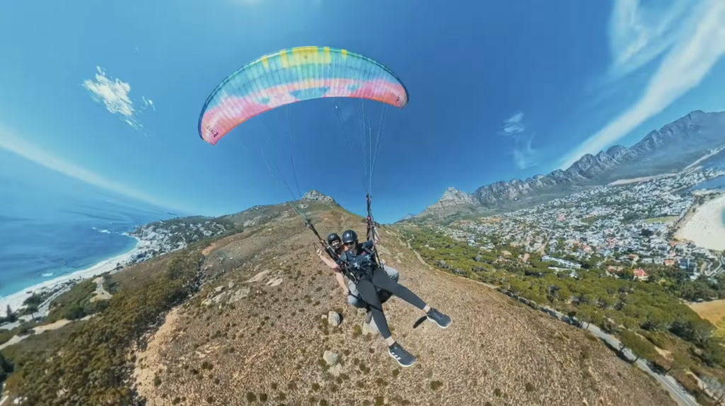
Vox Weather Meteorologists Annette Botha and Michelle Cordier decided to brave the altitude over Cape Town recently and experience the joys of paragliding for themselves. The idea was to go ‘beyond the forecast’ and learn how weather shapes this aerial sport, while also looking at the science behind good flying conditions.

Special thanks to adventure film maker, content creator and paraglider @MattAshwell, who flew with Annette and Michelle while giving commentary and explanations, as well as @SkyrideParagliding school for their first lesson.

Annette in the air!

Looking to the Skies

“People have been obsessed with the idea of flying for hundreds of thousands of years – and recently it was the turn of Michelle and myself!” says Annette.

“Here at Vox Weather, we thought it would be a fantastic idea to experience paragliding, as well as find out more about the important role of the weather in helping paragliders to get aloft and then stay airborne without the assistance of an engine.”
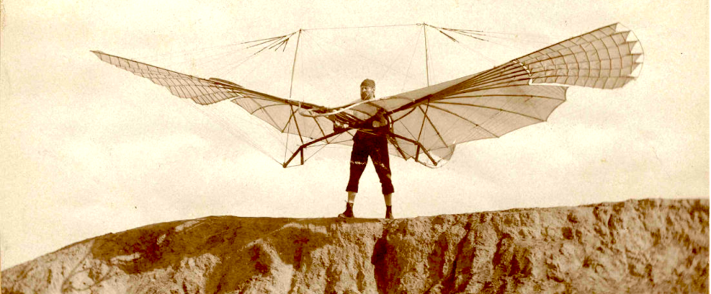
Michelle adds: “There are multiple stories about people in bygone years who didn’t only dream about flight, but actively attempted to fly by strapping birdlike wings or other devices onto themselves and jumping from towers – usually with very unfortunate results. As we know today, gravity is a force to be reckoned with!

“And so, for people to fly, they needed to find a way to overcome the force of gravity on body mass – in other words, people needed to find a way to create, or use, lift. This is a key concept in the sport of paragliding.”
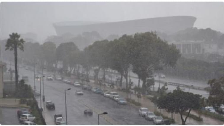
Image courtesy of lithub.com

Let’s go deeper into how Annette and Michelle traded the studio for the skies, and find out how paragliders stay in the air for so long without an engine.

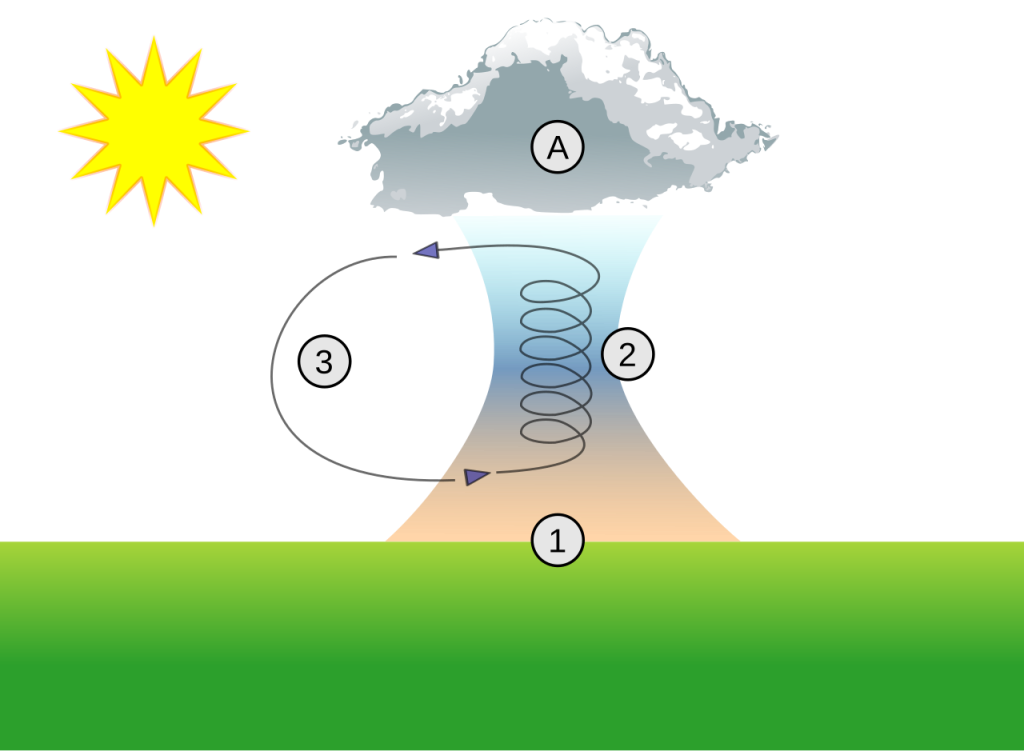
Image: Wikipedia

Weather’s Critical Role in Paragliding

After hiking up Lion’s Head in Cape Town to the take-off spot, the ladies first chatted to Matt and discussed what makes paragliding so special, as well as some of the science behind the sport.

“I think paragliding is one of the most weather-dependent sports out there,” says Matt, “and I generally start looking at the forecast two or three days in advance. The wind’s direction and strength are the two most important factors for any paragliding flight.”

Paragliders depend on thermals, which are rising air currents, to stay in the air for longer, without having to glide directly to the ground from their original height because of gravity’s effect.


“Paragliding is a three-dimensional sport,” says Matt. “You’re moving up and down in the atmosphere and the wind strength can change as you’re moving. And so it’s important to make sure that the wind is optimal where you take off and also higher up on your flight path, to make sure you don’t get blown away.

“I advise beginners to make sure that the thermals aren’t too strong on the day that you’re flying, so you don’t find yourself out of your depth with regards to the turbulence that you’re flying through.”

With regards to wind speed, he notes that the paragliders’ flying window is quite limited, at between about five and 25 kilometres per hour.

“Anything stronger, and you can’t fly because it’s too dangerous,” he explains, “and when it’s less, you can’t fly because there’s no lift. Besides the wind’s direction and strength, paragliders also look at the wind gradient, which is the increase in wind as you go higher in the atmosphere.”

And Now for a Spot of Science

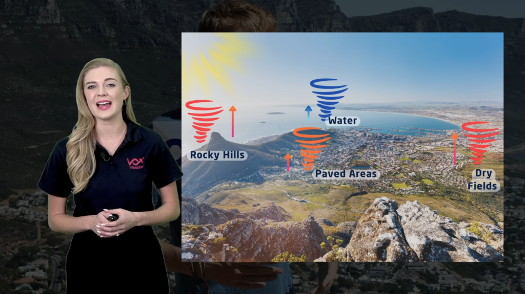
Michelle explains: “Thermals, as Matt outlined, are critical to paragliders, allowing them to ride these rising air currents and gain altitude. Thermals form in different areas and at different strengths because the sun heats the ground unevenly. For example, dry fields and rocky hills heat up quickly and create strong thermals, while cooler areas like water and green fields create weak or no thermals.

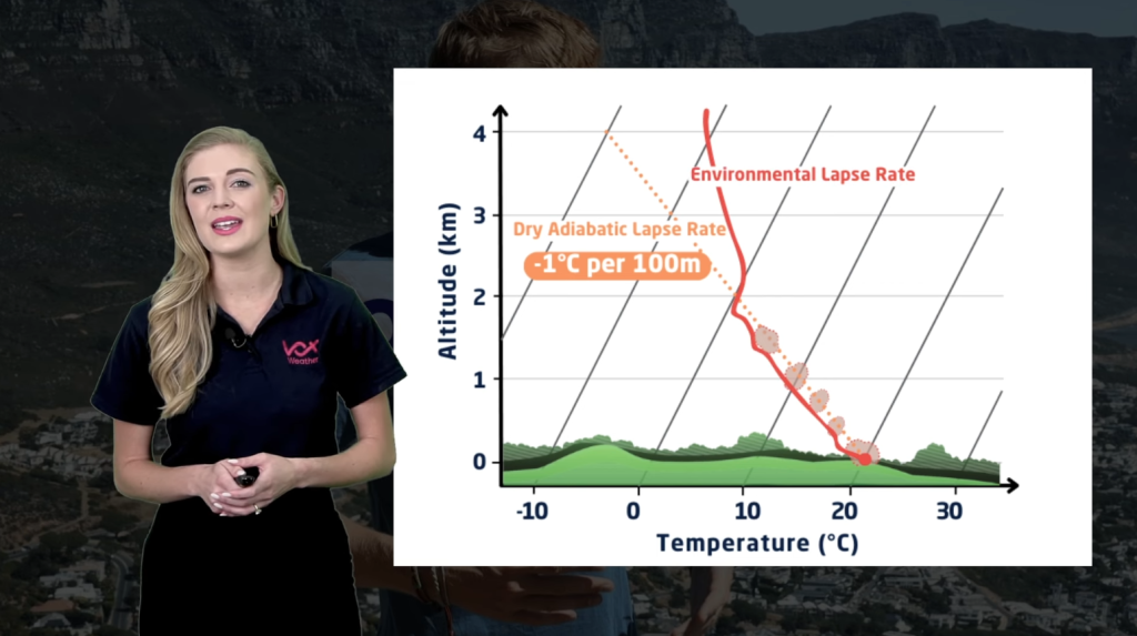
“Paragliders also use specific graphs to see if flying conditions are good. A ‘Skew-T’ graph shows how temperatures and dew point – the atmospheric temperature below which water droplets begin to condense, and dew can form – change with height. This helps to plot where thermals can form.”

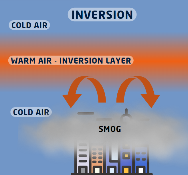
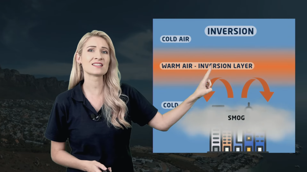
On the day that Annette and Michelle went paragliding, they experienced a weather phenomenon known as an ‘inversion’ (which had been anticipated, as per the forecast) and which prevented all those who were flying that day from going particularly high.

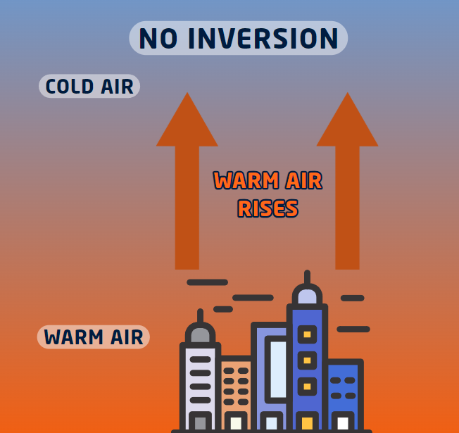
An inversion, in paragliding terms, means that at a certain altitude you find a band of air that is warmer than the air below and above it; this is an inversion.

Annette clarifies: “As seen in the graphics, we find that on a normal day, hot air continues to rise from the Earth, ultimately losing its heat and gradually becoming colder with atmospheric distance. With the creation of an inversion, however, we find a layer of warm air that traps the cooler air below it, preventing thermals from rising. This can limit a paraglider’s altitude and make it harder to stay airborne.”

Clouds often form an inversion for two reasons: firstly, because at an inversion the air mass changes characteristics, which often means that the combination of temperature and moisture is right to bring about the dew point; and secondly because the conditions attract the gathering of dust particles, which are necessary in cloud formation.

Matt adds: “We can clearly see how important weather forecasting is for paragliders, and we have a few specific options that we look at, including Windy and SkySight. Another very good site developed by a local guy is a weather forecasting site named RASP (Regional Atmospheric Soaring Prediction), which is what paragliders can use for very localised climatology in the Western Cape.”

Where Adventure Meets Atmosphere

There’s no doubt in Matt’s mind that paragliding is an addictive sport. He says: “The reason I’m hooked on paragliding is because of your ability to interact with the wind and be so high above the ground – and then of course the sensation of flying. To be able to do it so freely without an engine is just the best feeling ever!”

Annette adds: “We want to give Matt a huge shout-out for sharing his passion with us and showing us the skies from a different perspective – where adventure meets atmosphere!”

Stay tuned for more adventures ‘Beyond the Forecast’, where Vox Weather will explore how the weather shapes adventures across the country.