A strong cold front is expected to reach South Africa on Sunday 09 August, followed by the development of a cut-off low from Monday. Vox Weather Meteorologist Michelle du Plessis rounds up the forecast for the Women’s Day long weekend and beyond.

Forecast confidence has improved for Sunday and Monday, with more than one model now indicating significant snowfall over parts of the eastern interior. However, Tuesday’s forecast remains uncertain.

Sunday 9 August

The cold front will move across the southern parts of the country, bringing cold, wet and windy weather.

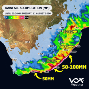
🌧️ The heaviest rainfall is expected along the South Coast, including the Garden Route, and across large parts of the Eastern Cape. Up to 20 mm of rain could fall in some areas during the day.

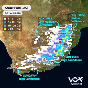
❄️ Only light snowfall is currently expected over the mountains of the Western Cape, around Sutherland and the Nuweveld Mountains.

Heavier snowfall is likely over the mountains and high-lying areas of the Eastern Cape, where some locations could already receive around 10 cm of snow.

Snow will also begin spreading towards Lesotho, the southern Drakensberg and nearby high-lying areas.

Monday 10 August

A high-pressure system ridging behind the cold front will maintain cold, wet and windy conditions along the southern and eastern coastline, with another 10 mm of rain possible along parts of the South Coast.

Meanwhile, a cut-off low is expected to develop and bring heavier rain farther east.

🌧️ The heaviest rainfall is currently expected over KwaZulu-Natal, the Highveld and eastern Free State, where 15–30 mm could fall within 24 hours. Isolated showers and thunderstorms are also likely over Gauteng, Limpopo and North West.

❄️ Both the European Centre for Medium-Range Weather Forecasts (ECMWF) and Global Forecast System (GFS) models are indicating the likelihood of significant snowfall over:

  • The Eastern Free State
  • The bordering areas of Free State and KwaZulu-Natal
  • The Mpumalanga Highveld, including areas around Ermelo, Dullstroom and Standerton
  • Lesotho and the southern Drakensberg
  • The KwaZulu-Natal Midlands, including areas around Underberg and Kokstad
  • High-lying parts of the Eastern Cape

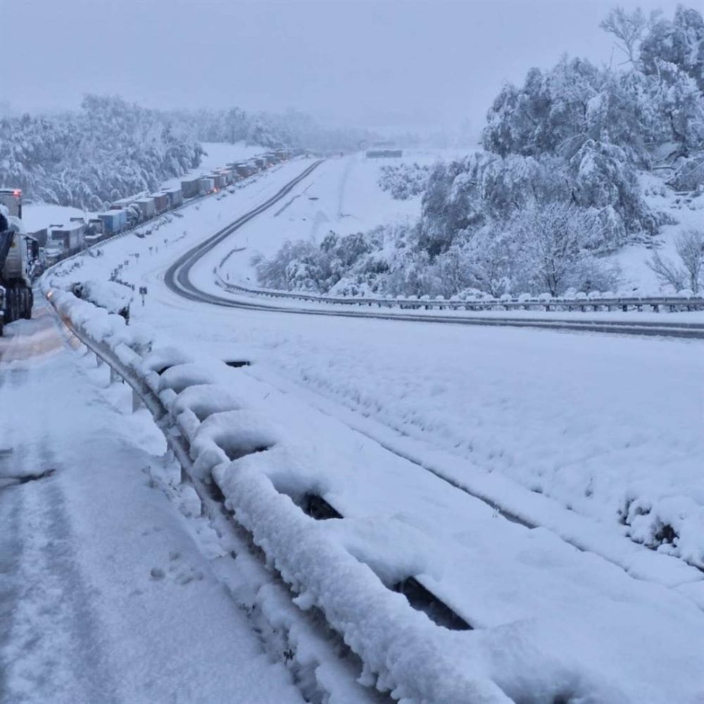
⚠️ Major travel disruptions are possible. Van Reenen’s Pass and other mountain routes could close.

As seen during the September 2024 snow event, vehicles can become trapped for hours. Avoid unnecessary travel between Free State, KwaZulu-Natal and Mpumalanga on the public holiday and Tuesday.

Light snow remains possible over south-eastern Gauteng, including places like Delmas, Nigel, Benoni and Vereeniging.

Snow is not currently expected in Pretoria, and any snow falling with rain over Gauteng may struggle to settle.

Image: Snow at Van Reenen’s Pass, 2024 (image: The Citizen)
Tuesday 11 August

Tuesday’s rainfall and snowfall forecasts remain highly uncertain due to differences between the major forecast models.

🌧️ The ECMWF model is indicating potentially heavy rainfall over eastern Limpopo and Mpumalanga, with isolated totals of up to 50 mm. It is also showing up to 50 mm along parts of the East Coast.

However, the GFS model is not currently showing the same level of heavy rainfall over the north-east.

❄️ The ECMWF model is indicating further snowfall over:

  • The Mpumalanga Highveld
  • South-eastern Gauteng
  • The Eastern Free State
  • Lesotho and the southern Drakensberg

In contrast, the GFS model currently limits Tuesday’s snowfall mainly to the southern Drakensberg.

We therefore cannot yet say with certainty how Tuesday will unfold.

Important Forecast Note

More than one forecast model is now in reasonable agreement regarding the expected rain, cold and snow on Sunday and Monday.

However, the exact position and strength of the cut-off low will determine where the heaviest rain and snow occur, particularly on Tuesday.

Even a small shift in the system could significantly change the forecast.

Vox Weather will provide another detailed update on Sunday as the system moves closer and forecast confidence improves.

One thing remains certain: A MAJOR COLD BLAST IS ON THE WAY! 🥶❄️🌧️

Did you ever notice how the increased winds in August in South Africa’s interior are closely linked to the seasonal transition from winter to spring?

Vox Weather Meteorologist Michelle du Plessis tells us more.

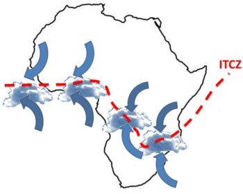
During winter, much of South Africa is dominated by a stable high-pressure system over the interior. By late winter, this high-pressure system begins shifting as the Intertropical Convergence Zone (ITCZ) also moves further south, while cold fronts from the southwest continue to pass across the country.

The interaction between these different air masses, namely colder, denser air from the west and warmer, lighter air building over the interior, creates a tighter pressure gradient. A tighter pressure gradient causes air to move faster, which is experienced as stronger winds. 

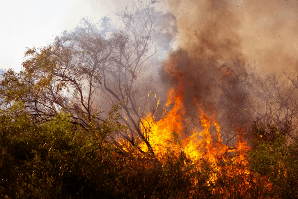
At this time of year, vegetation and soils are generally at their driest after months of limited rainfall. This allows dust and sand to be lifted more easily by the wind, and also creates ideal fuel for fires. The combination of dry vegetation, low humidity and strong winds makes it far easier for flames to spread rapidly and become uncontrollable. 

These conditions are a key reason why August is one of the worst times for any open burning, as even a small spark can quickly escalate into a runaway wildfire.

When Will the Rains Come?

The ‘August winds’ is generally a late‑winter feature that usually builds from late July, peaks through August, and fades during early to mid‑September. Mechanistically, the windiness is driven because of strengthening pressure gradients between lingering cold fronts to the southwest and a warming interior.

In most years, the interior’s first spring showers arrive mid to late September, but they’re usually light and isolated. The true start of the rainy season, with consistent, useful rainfall, tends to occur from October into early November.

Recent research confirms a shift toward a later onset of rain, especially in Gauteng and surrounding areas. What was once expected in September now often only establishes in October or even November.

This trend is linked to climate change and ENSO cycles, with El Niño years delaying rain and La Niña favouring earlier onset.

The bottom line is that the spring rains are coming, but they’re running later than they used to.

As the frontal influence relax and low‑level moisture flux from the northeast strengthens, winds generally ease from their late‑winter peaks and thunderstorm days begin to appear.

A practical rule of thumb is a one to four week overlap or transition: the gusty late‑winter pattern tapers off in early to mid-September; the first weak convective events pop up mid‑ to late September; and finally more reliable rainfall usually arrives in October.

Are We Seeing a Change in the Beginning of the Seasonal Spring Rains?

The short answer – in Michelle’s opinion – is yes.

She believes that there has been a change in the beginning of the seasonal spring rains in South Africa in recent times.

It matters because:

  • Rainy seasons are arriving later, shortening the wet window: A study across southern Africa confirms that the wet season is starting later, which also means shorter rainy periods and lower overall rainfall in many regions.
  • Climate change is a major culprit: Longer-term climate projections, especially under high emissions scenarios, suggest that shifts in global rainfall timing are already underway. In southern Africa, these shifts are tied to delayed wet-season starts, likely influenced by warming trends and changes in atmospheric circulation.

The Role and Effects of Fire

In the Western Cape, fire is essential for fynbos regeneration. In the interior grasslands and savannas, fire also plays an important ecological role, but timing and intensity matter.

Well-timed, cooler burns (usually done controlled, under calm, moist conditions) help remove old grass, stimulate new growth, and control bush encroachment.

However, August fires driven by strong winds are often too hot and fast, making them more destructive than beneficial. These fires can damage soil, kill recovering vegetation, and destroy grazing land.

So while fire is natural and even necessary in some ecosystems, the August fire season in the interior is more risky than helpful, especially when fires are uncontrolled and fuelled by dry, windy weather.

What Does This Mean on the Ground?

Farmers, planners and residents relying on spring rains can no longer count on September showery starts. In practice, October is fast becoming the more dependable month for meaningful rainfall, especially across Gauteng and the interior.

The bottom line?

Yes, spring rains are shifting later in South Africa. Research confirms that it’s happening, and that climate changes are steering the trend.

  • Recent studies show that the later start to the rainy season is linked to a combination of climate change and natural climate patterns.
  • Climate change is shifting weather patterns globally, including when and how rain falls in South Africa. Warmer temperatures affect how long dry seasons last and delay the arrival of reliable rain.

El Niño and La Niña also play a role. El Niño years tend to bring later and weaker rains, while La Niña often brings earlier and wetter conditions. We are expecting a weak La Niña to develop by summer, which may result in above-normal rain in the summer over the summer rainfall regions.