Seasonal Outlook: A Stormy Start to 2026 with a Sharp East–West Contrast
When you look at recent weather maps of South Africa, you could be forgiven for thinking that we are living in two different countries. Vox Weather Meteorologist Michelle du Plessis shares the first seasonal outlook of 2026.
Please note: All graphs and images are taken from the latest Langtermyn Landbou-Weervoorspelling, and the text on the visuals is in Afrikaans. You can also view the Landbou show here.
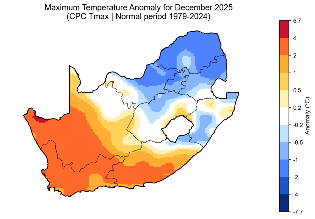
The first agricultural weather outlook of 2026 begins with a country already deeply shaped by summer weather extremes. While large parts of South Africa experienced intense thunderstorms, flooding and high humidity in December, the western regions faced the opposite: extreme heat, dryness and severe fire danger.
The key question now is whether December was just a noisy outlier, or whether it signals a broader pattern for the rest of summer and early autumn.
December 2025: A month of extremes
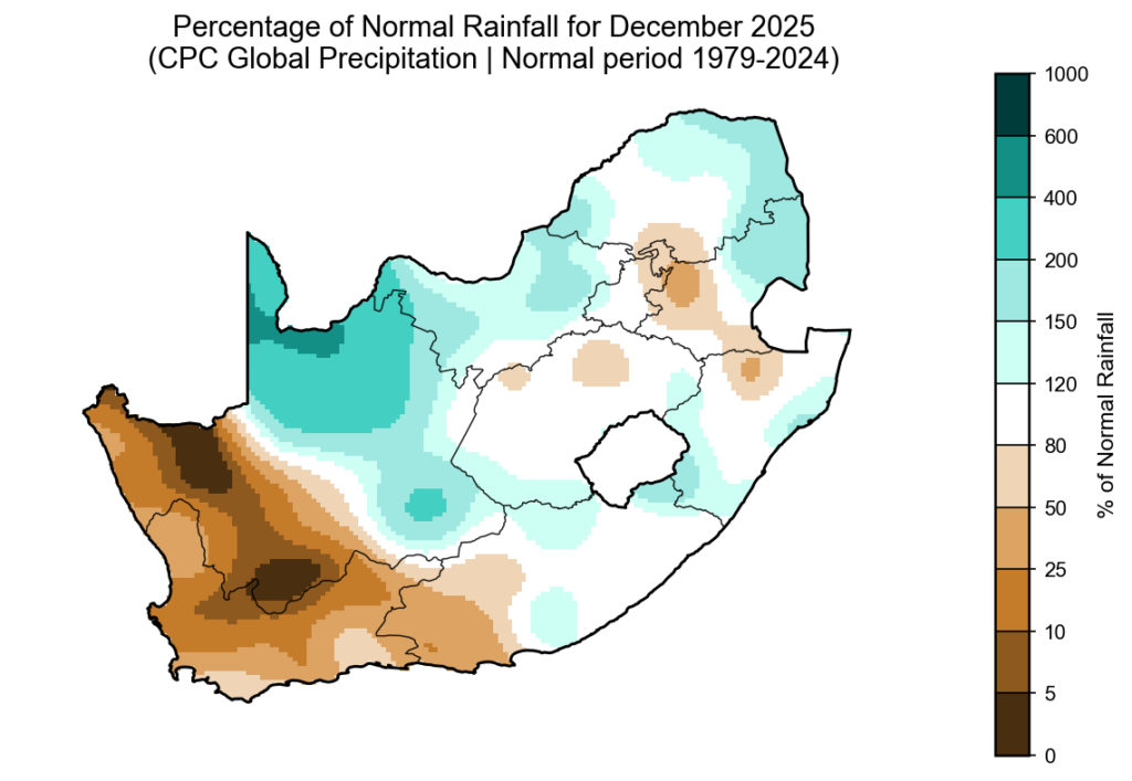
According to the CPC percent-of-normal rainfall map for December 2025 (based on the 1979–2024 climate period), a classic summer contrast emerged across the country.
The northern, central and eastern regions recorded above-normal rainfall, while the south-western and western areas — particularly the Western Cape, southern Cape and parts of the Northern Cape — were much drier than normal.
Although the Western Cape normally receives most of its rainfall in winter, 2025 was exceptionally dry. It now ranks among the three driest years of the past four decades for the province.
Severe convective storms in the north and east
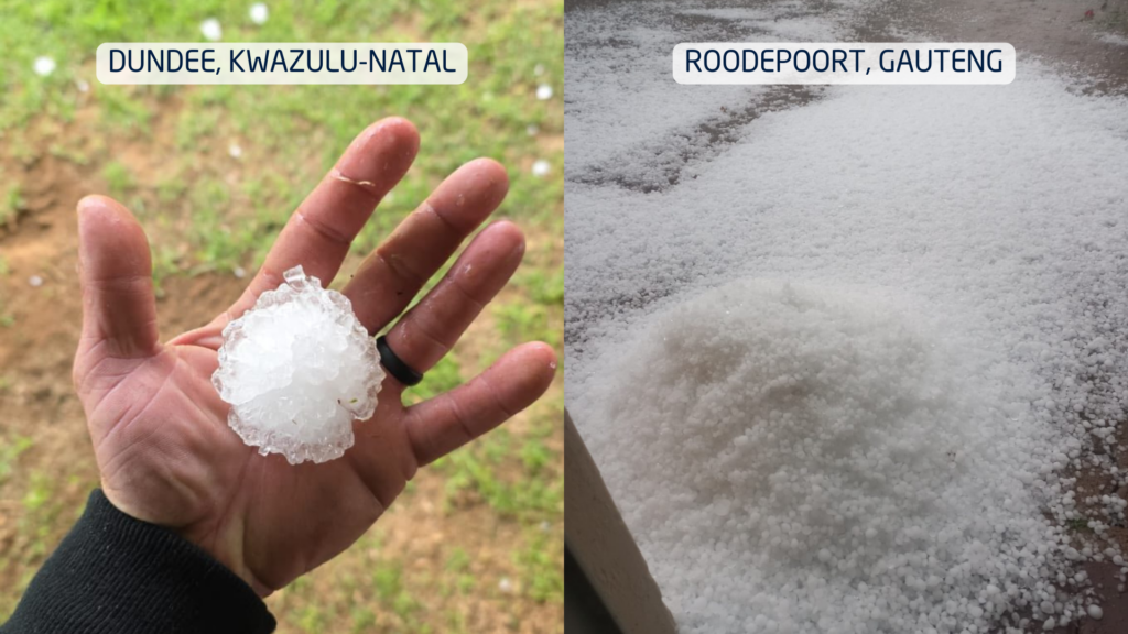
The above-normal rainfall across the summer-rainfall region was driven by powerful cumulonimbus thunderstorms. These towering cloud systems are responsible for lightning, hail, intense downpours and flash flooding.
Large parts of the northern and eastern provinces saw repeated thunderstorm outbreaks. A particularly shocking event occurred in the Majaneng area near Hammanskraal, where reports indicated that around 40 people were struck by lightning around 3 January.
Several storms also produced large hail, causing localised agricultural and property damage. Flooding was widespread in areas where storms repeatedly tracked over the same catchments.
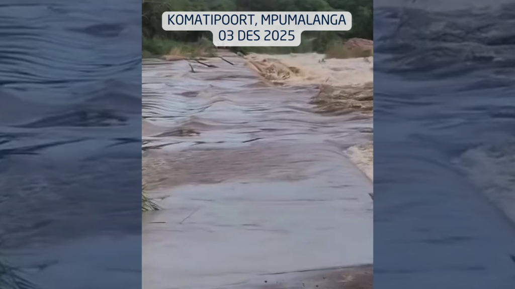
In the Lowveld, impacts became severe. On 3 December, a vehicle carrying eight people was swept away at the Komatipoort low-water bridge by the swollen Nkomazi River, highlighting how deadly summer river crossings can become.
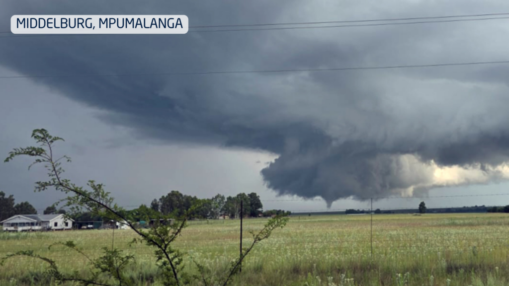
On New Year’s Day, two tornadoes were confirmed in Mpumalanga, near Middelburg and Carolina, causing damage to buildings and infrastructure.
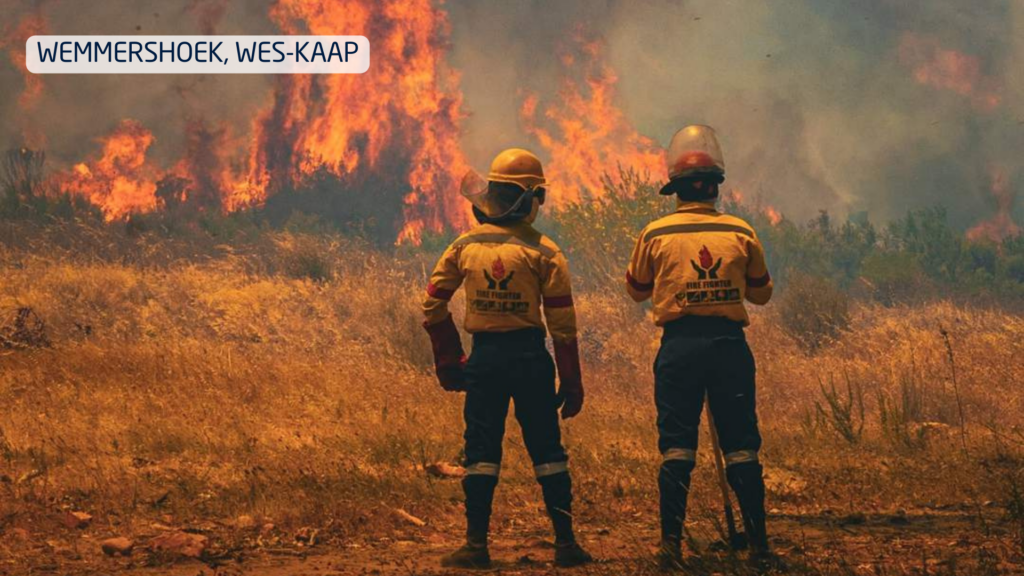
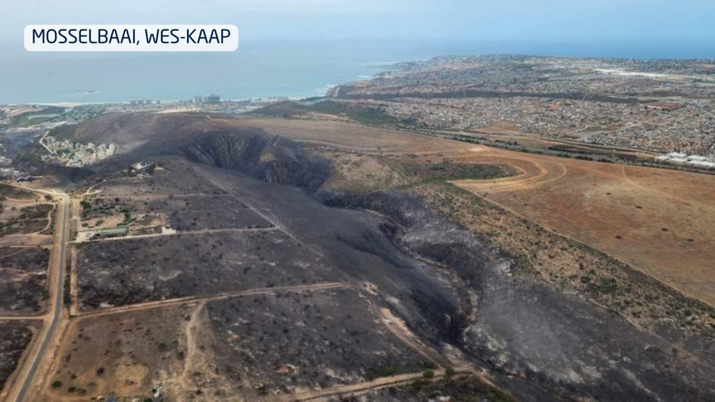
Extreme fire season in the west
While storms dominated the east, the western parts of the country endured heat, strong winds and very little meaningful rainfall. This combination triggered one of the most severe fire seasons in years.
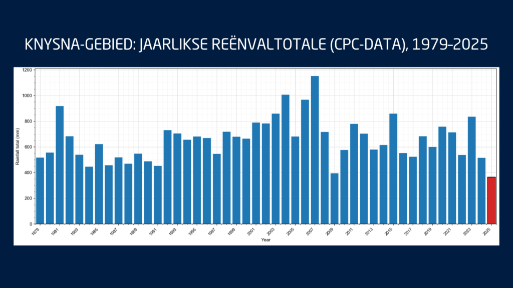
These fires occurred while the southern Cape was already under severe water stress. Knysna entered Level 4 water restrictions, with only days of usable water left in the Akkerkloof Dam. Rainfall records show that 2025 was the driest year in over 40 years for the area, pushing the town dangerously close to so-called Day Zero.
Disaster management confirmed that at least 10 major wildfires burned over a single intense week, destroying approximately 90,000 hectares and damaging dozens of structures.
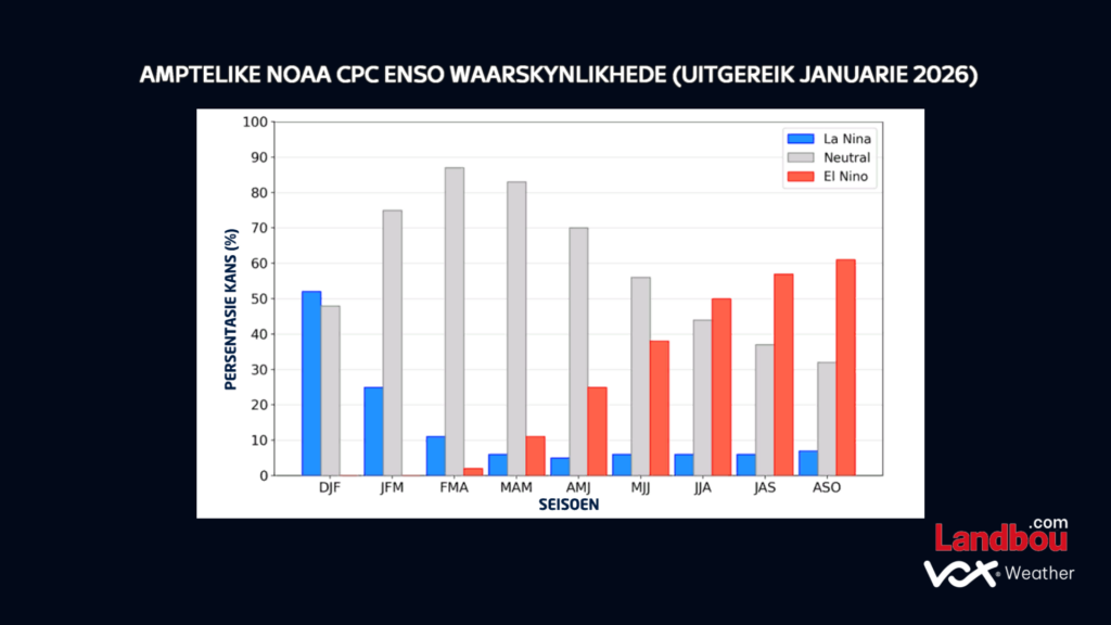
What ENSO is telling us
The latest ENSO indicators continue to show La Niña conditions persisting through the rest of summer. These are expected to weaken into neutral conditions during autumn, while the probability of El Niño increases toward late winter and early spring.
For agriculture, this suggests:
Above-normal rainfall risks continue in the east during late summer
More variable conditions into autumn
A growing risk of warmer and drier conditions later in the year as El Niño develops
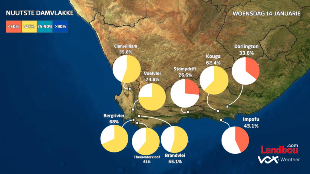
Water resources under pressure
The Western Cape’s dam levels currently average 66.3%, down sharply from 86.5% at the same time last year. This significant drop highlights how vulnerable the region already is before the winter rainfall season even begins.
In the Eastern Cape, dam levels also remain below last year’s levels, averaging 75.4% compared to 81.3% a year ago. Although the Eastern Cape forms part of South Africa’s year-round rainfall zone, this does not mean rainfall is evenly distributed. Over recent months, most of the rain has fallen further north and east, with major systems missing much of the southern and eastern Cape. This explains why, despite its climate, the region is still under water pressure.
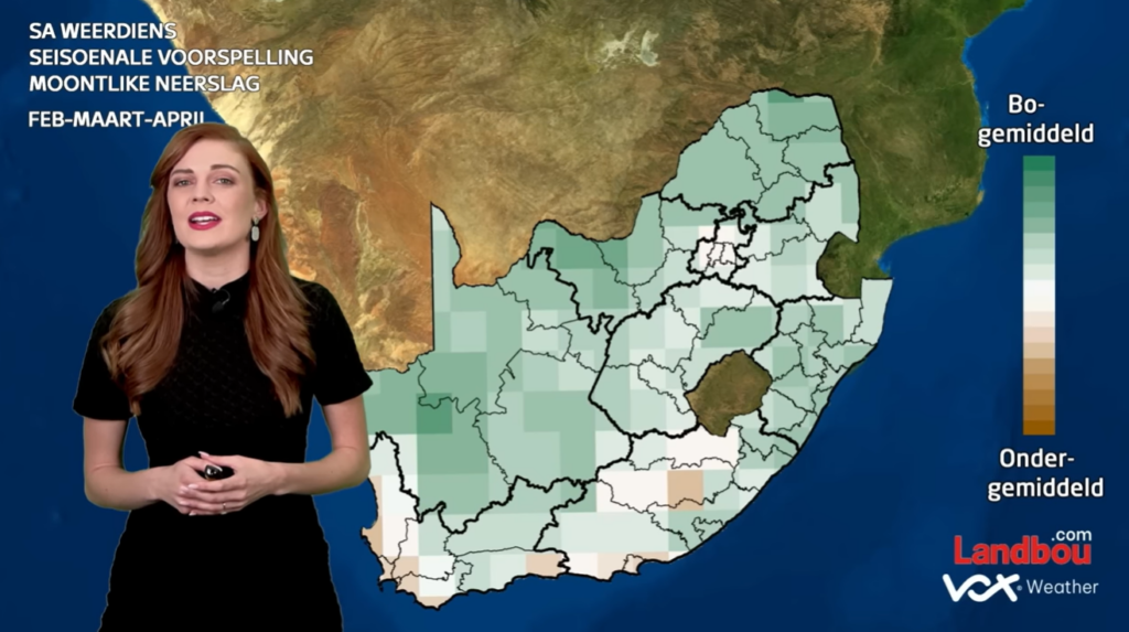
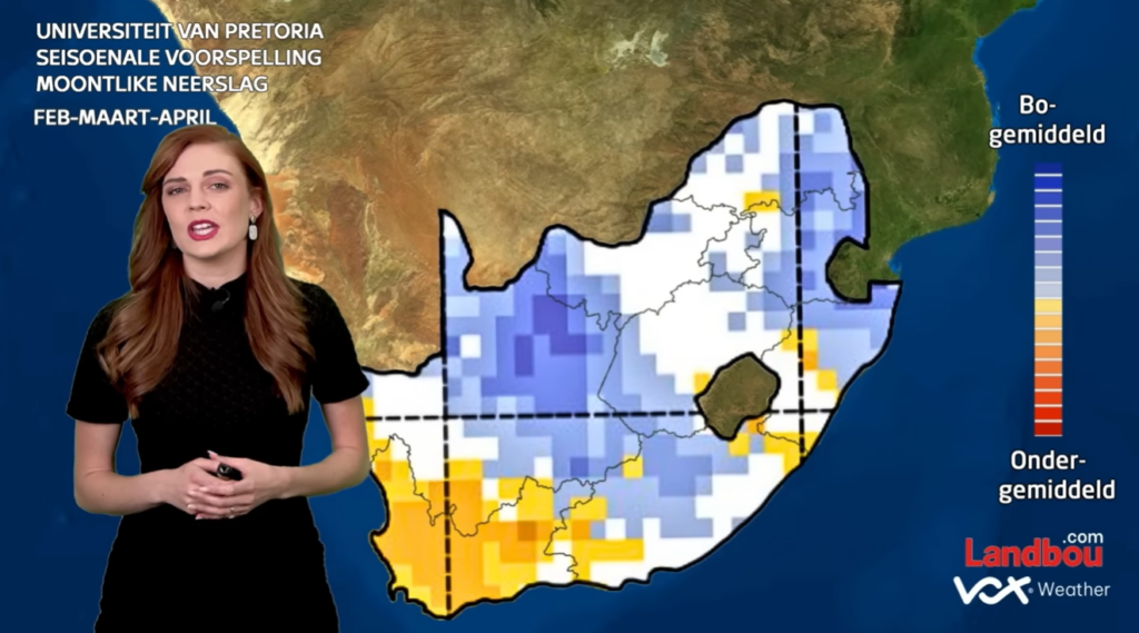
What this means for the months ahead
December was not an isolated event. It reflects a broader climate pattern of:
Wet, storm-prone conditions in the east
Hot, dry and fire-prone conditions in the west
The seasonal outlook suggests this contrast is likely to persist through late summer and early autumn.
For farmers, this means that in the east and Lowveld, there is continued risk of flooding, crop disease and soil erosion; while in the west, there will be ongoing pressure on water resources, fire management and drought planning.
Seasonal models cannot predict individual storms, but they do provide reliable guidance on overall trends. And the trend for early 2026 is already clear: A wet east, a dry west, and significant agricultural challenges across both.
Climate Change and Weather Forecasting: Linking Science and People
Increased understanding helps communities prepare for extreme weather events
Climate change is affecting South Africans by significantly altering local weather patterns through higher temperatures, as well as the occurrence of extreme weather events. In fact, its impact in recent years has been so great that the government is planning to launch a national Climate Change Response Fund, which is intended to help pay for infrastructure to make South Africa more climate-resilient in the future.
This thinking reminds us of the importance of weather forecasting, both in the short term as well as over longer timeframes.
“While the planet’s climate has changed continually over the last 800,000 years through natural cycles and fluctuations, scientists have shown that human activity is driving our present spike in above normal temperatures globally,” says Vox Weather Meteorologist, Annette Botha.
“In particular, the burning of fossil fuels, such as coal, oil, gasoline and natural gas, has led to the ‘greenhouse’ effect, which is metaphorically and literally causing our planet to burn.”
In this article, we discuss how the science of weather forecasting can provide a greater understanding of climate change, and thus help countries and communities around the world to be better prepared against the possibility of extreme weather events – as well as realising the critical importance of continuing the fight to reduce ‘greenhouse gas’ emissions.
Putting Climate Change Under the National SA Spotlight
As outlined previously, President Cyril Ramaphosa announced the implementation of the national Climate Change Response Fund (CCRF) during the February 2024 State of the Nation Address (SONA). The CCRF is intended to be a collaborative effort between the government and the private sector to fight against the increasingly devastating impacts of the climate crisis.
During his announcement, President Ramaphosa noted the occurrence of devastating wildfires in the Western Cape, destructive floods in KwaZulu-Natal, intense heat waves in the Northern Cape, a persistent drought in the Eastern Cape and intense storms in Gauteng.
“While individual events like floods or fires cannot be solely attributed to climate change,” says Botha, “we are observing a broader trend: a steady increase in global temperatures and a rise in the frequency and intensity of extreme weather events. Climate is naturally variable, but human-driven warming is clearly shifting the baseline, making such events more likely and often more severe.”
Reduced water levels, Gamtoos Dam, Eastern Cape (Photo: The Herald)
Extreme Weather Events: Cause and Effects
Global warming has come about because of the increasing concentration of carbon dioxide (CO2) and other greenhouse gases – including water vapour, methane, nitrous oxide and fluorocarbons – that trap heat in the earth’s atmosphere and so cause a rise in global average temperatures.
Botha notes: “Because warmer air can hold more moisture, climate change results in more intense rainfall. As a result, because rainfall is increasing on average across the world, the chances of flooding are getting higher. On the other hand, climate warming also increases evaporation on land, which can worsen drought and create conditions more prone to wildfires. Added to this, the Earth’s warmer and moister atmosphere, together with warmer oceans, can create stronger hurricanes.
“Rising sea levels, which are partly caused by melting ice in the poles, increase the amount of seawater that is pushed onto shore during coastal storms, resulting in more destructive storm surges and flooding. The net result is that global warming is leading to more extreme weather events, and we have seen all of these climate change results in South Africa over the past few years.”
Lives are obviously at stake in the event of severe weather conditions if information isn’t available for warning purposes.
Botha notes: “Early warnings give people time to prepare against severe weather events like floods, tornadoes and lightning storms, whether that’s evacuating, securing property or staying indoors. Without timely updates, communities are left vulnerable, increasing the risk of damage, injuries and even loss of life.
“However, climate change is impacting on weather forecasting by altering weather patterns and increasing the frequency and intensity of extreme events, making long-term predictions more challenging.”
This is where technology comes in, to further back up the science of weather forecasting.
IBM Graf - weather forecasting via super computer
The Science and Technology of Weather Forecasting
Botha clarifies: “While short-term weather forecasts remain accurate, climate change introduces uncertainties in long-range predictions, due to shifts in climate variables like sea surface temperature and atmospheric circulation patterns. Scientists are developing new modelling techniques and tools to improve the accuracy of these long-term predictions.
“Meteorologists pull data from multiple sources including satellites, radars, weather stations and even high-altitude weather balloons. We also use global weather models and international meteorological databases. In South Africa, the South African Weather Service (SAWS) is a key provider of local weather data.”
Around the globe, high-performance computing (HPC) is crucial for weather forecasting today because it enables the efficient processing of vast amounts of data and complex mathematical models, leading to more accurate and timely predictions. HPC involves the use of multiple supercomputers to process complex and large calculations. This technology provides sufficient computational resources to improve the accuracy of short-term weather forecast systems models, with the aim of further reducing the severity of weather and climate related natural disasters.
Linking People Through Technology
With climate change bringing more frequent and extreme weather events, platforms like Vox Weather are becoming even more important, says Botha.
“As South Africa’s first independent digital weather platform, Vox Weather delivers real-time, hyperlocal forecasts via social media and our website. We make weather updates engaging and accessible, and with close to 500,000 followers, we’re reaching more people than ever.
“We look forward to continuing to add information on climate change to our daily short-term broadcasts, as well as continuing to update our followers on the perils of climate change, and the ways in which both countries and individuals can play their role in helping to reduce greenhouse gases, in order to reduce global warming – for our future, and that of future generations,” she concludes.