Seasonal Outlook: A Stormy Start to 2026 with a Sharp East–West Contrast
When you look at recent weather maps of South Africa, you could be forgiven for thinking that we are living in two different countries. Vox Weather Meteorologist Michelle du Plessis shares the first seasonal outlook of 2026.
Please note: All graphs and images are taken from the latest Langtermyn Landbou-Weervoorspelling, and the text on the visuals is in Afrikaans. You can also view the Landbou show here.
The first agricultural weather outlook of 2026 begins with a country already deeply shaped by summer weather extremes. While large parts of South Africa experienced intense thunderstorms, flooding and high humidity in December, the western regions faced the opposite: extreme heat, dryness and severe fire danger.
The key question now is whether December was just a noisy outlier, or whether it signals a broader pattern for the rest of summer and early autumn.
December 2025: A month of extremes
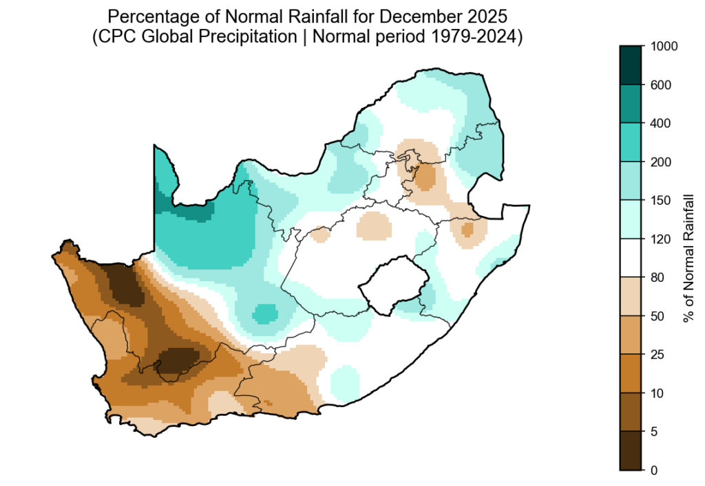
According to the CPC percent-of-normal rainfall map for December 2025 (based on the 1979–2024 climate period), a classic summer contrast emerged across the country.
The northern, central and eastern regions recorded above-normal rainfall, while the south-western and western areas — particularly the Western Cape, southern Cape and parts of the Northern Cape — were much drier than normal.
Although the Western Cape normally receives most of its rainfall in winter, 2025 was exceptionally dry. It now ranks among the three driest years of the past four decades for the province.
Severe convective storms in the north and east
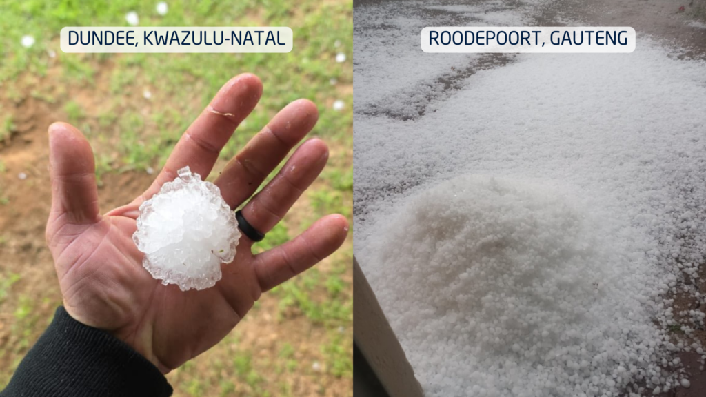
The above-normal rainfall across the summer-rainfall region was driven by powerful cumulonimbus thunderstorms. These towering cloud systems are responsible for lightning, hail, intense downpours and flash flooding.
Large parts of the northern and eastern provinces saw repeated thunderstorm outbreaks. A particularly shocking event occurred in the Majaneng area near Hammanskraal, where reports indicated that around 40 people were struck by lightning around 3 January.
Several storms also produced large hail, causing localised agricultural and property damage. Flooding was widespread in areas where storms repeatedly tracked over the same catchments.
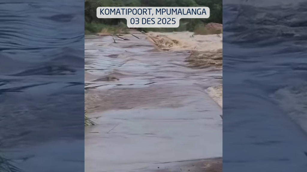
In the Lowveld, impacts became severe. On 3 December, a vehicle carrying eight people was swept away at the Komatipoort low-water bridge by the swollen Nkomazi River, highlighting how deadly summer river crossings can become.
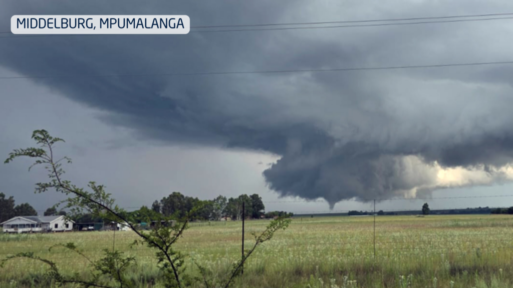
On New Year’s Day, two tornadoes were confirmed in Mpumalanga, near Middelburg and Carolina, causing damage to buildings and infrastructure.
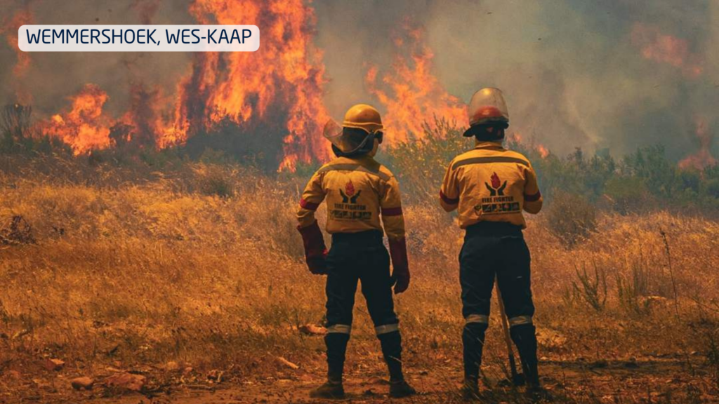
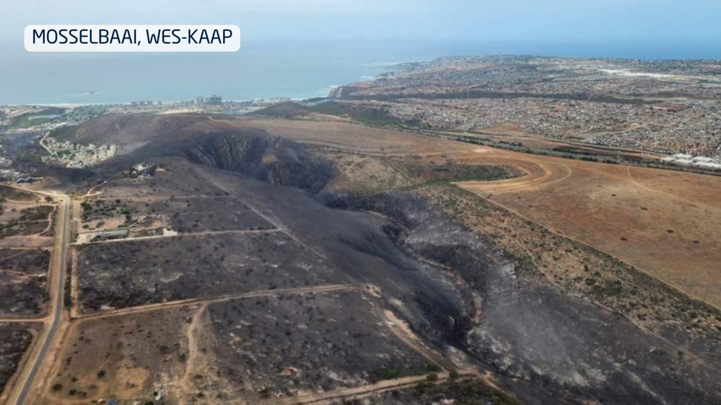
Extreme fire season in the west
While storms dominated the east, the western parts of the country endured heat, strong winds and very little meaningful rainfall. This combination triggered one of the most severe fire seasons in years.
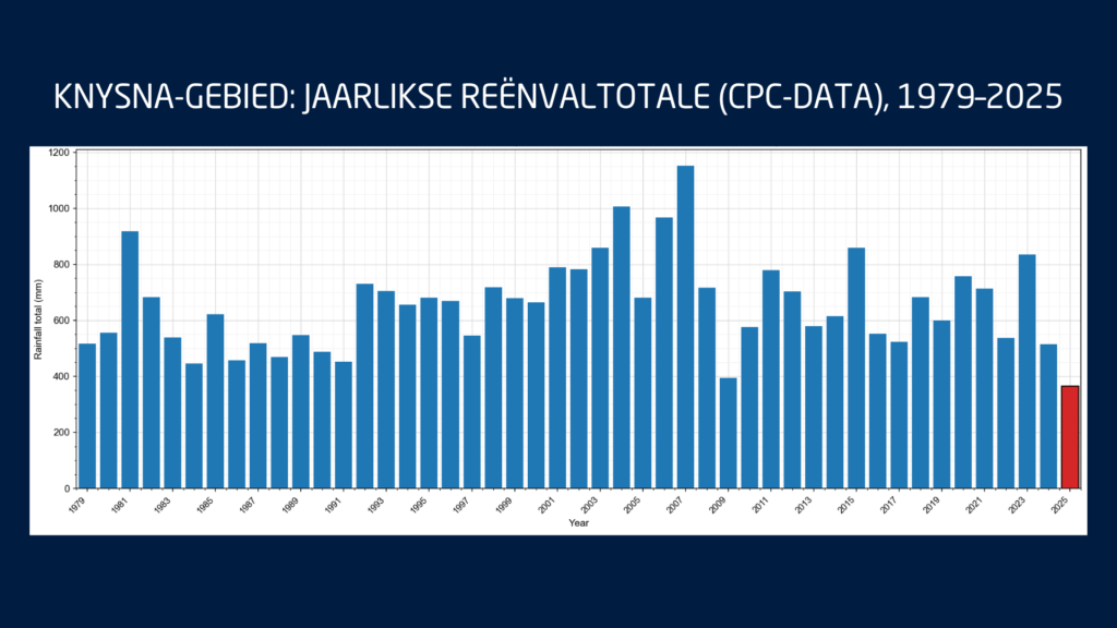
These fires occurred while the southern Cape was already under severe water stress. Knysna entered Level 4 water restrictions, with only days of usable water left in the Akkerkloof Dam. Rainfall records show that 2025 was the driest year in over 40 years for the area, pushing the town dangerously close to so-called Day Zero.
Disaster management confirmed that at least 10 major wildfires burned over a single intense week, destroying approximately 90,000 hectares and damaging dozens of structures.
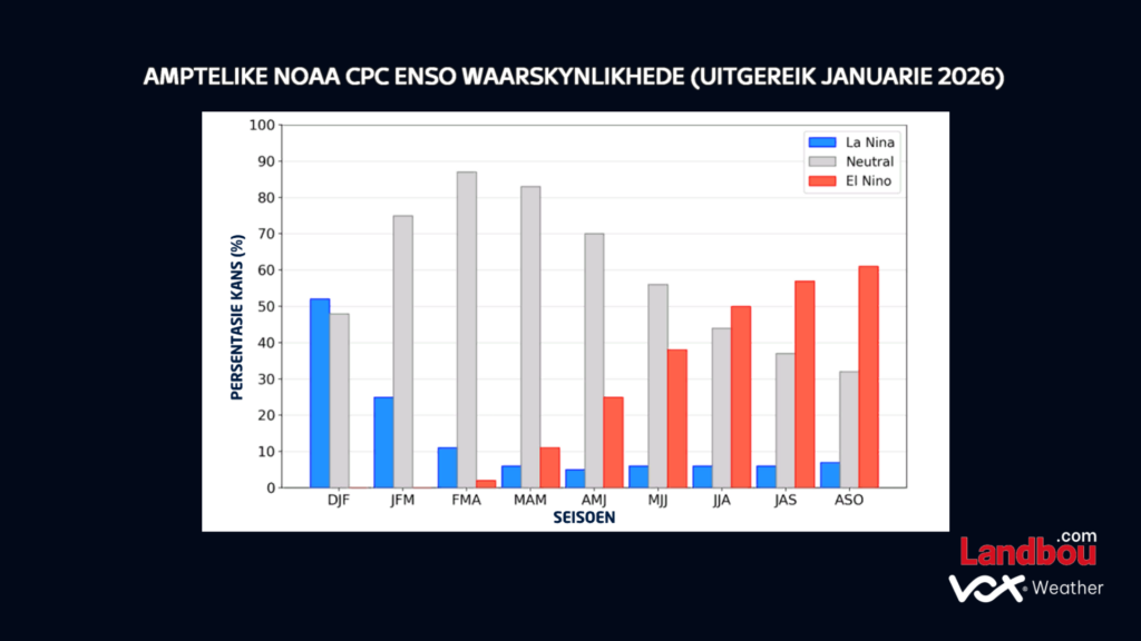
What ENSO is telling us
The latest ENSO indicators continue to show La Niña conditions persisting through the rest of summer. These are expected to weaken into neutral conditions during autumn, while the probability of El Niño increases toward late winter and early spring.
For agriculture, this suggests:
Above-normal rainfall risks continue in the east during late summer
More variable conditions into autumn
A growing risk of warmer and drier conditions later in the year as El Niño develops
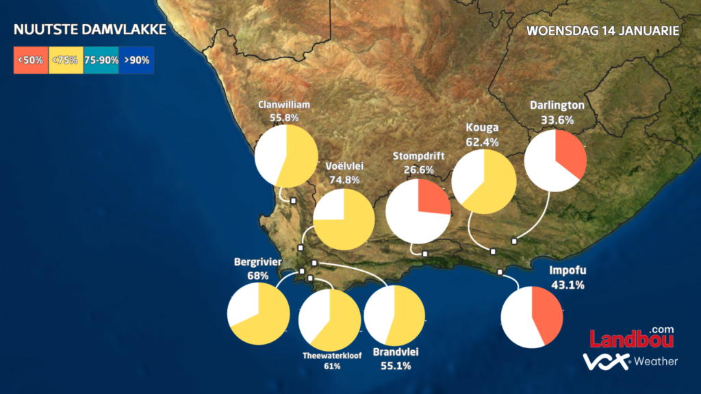
Water resources under pressure
The Western Cape’s dam levels currently average 66.3%, down sharply from 86.5% at the same time last year. This significant drop highlights how vulnerable the region already is before the winter rainfall season even begins.
In the Eastern Cape, dam levels also remain below last year’s levels, averaging 75.4% compared to 81.3% a year ago. Although the Eastern Cape forms part of South Africa’s year-round rainfall zone, this does not mean rainfall is evenly distributed. Over recent months, most of the rain has fallen further north and east, with major systems missing much of the southern and eastern Cape. This explains why, despite its climate, the region is still under water pressure.
What this means for the months ahead
December was not an isolated event. It reflects a broader climate pattern of:
Wet, storm-prone conditions in the east
Hot, dry and fire-prone conditions in the west
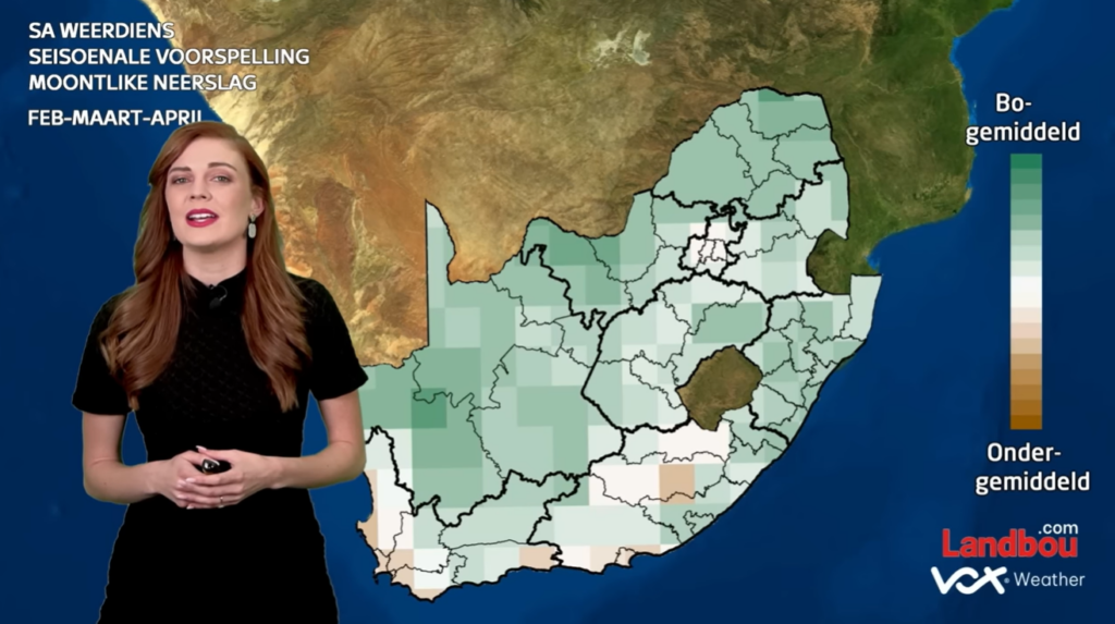
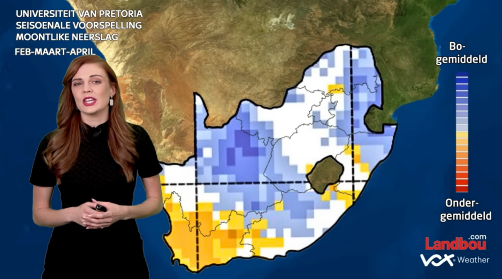
The seasonal outlook suggests this contrast is likely to persist through late summer and early autumn.
For farmers, this means that in the east and Lowveld, there is continued risk of flooding, crop disease and soil erosion; while in the west, there will be ongoing pressure on water resources, fire management and drought planning.
Seasonal models cannot predict individual storms, but they do provide reliable guidance on overall trends. And the trend for early 2026 is already clear: A wet east, a dry west, and significant agricultural challenges across both.
Seasonal Forecast: A Wetter-Than-Normal Summer for the East; Heat and Wind in the West
Vox Weather Meteorologist Annette Botha gives us the details on the 2025 / 2026 summer season – looking back on some of the drama that the weather has recently thrown at us, and what we can expect going into next year.
You can also click here to see Annette presenting this information in a short video in Afrikaans, as part of the regular ‘Langtermyn Landbou-Weervoorspelling’ series, and experience some spectacular additional video footage of recent weather-related visuals that are highlighted here.
South Africans have just come through one of the most dramatic Novembers in recent years – it was a month marked by relentless thunderstorms in the north and east, with widespread hail, local flooding, and strong winds in the Western Cape.
Now, as we turn the corner into December, the latest seasonal forecasts point to a summer of strong contrasts: wet, stormy and cooler in the east, but hot, windy and fire-prone in the west.
A Record-Breaking End to Spring
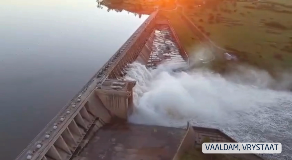
November delivered an onslaught of thunderstorms across Gauteng, Limpopo, North West, the Free State and the drought-stricken Eastern Cape. Many large dams responded quickly: the Vaal, Gariep and Bloemhof Dams rose sharply, with several spilling over.
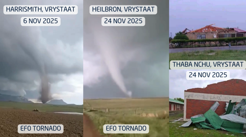
Thunderstorms were fuelled by unstable, moisture-rich tropical air that repeatedly surged across the interior. More than one EF0 tornado was reported in parts of the Free State, a reminder that South Africa’s ‘tornado corridor’ can produce short-lived but destructive events almost every summer.
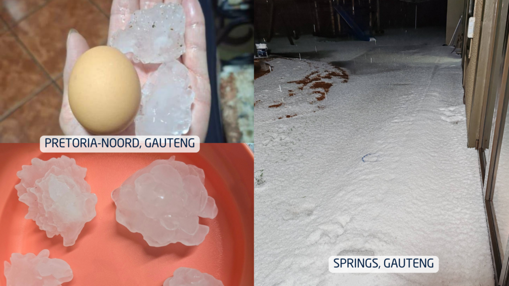
Hail was another standout feature of the month. In some towns, small hail accumulated so thickly that streets resembled winter scenes, trapping cars and residents. In other areas, hail the size of chicken eggs caused extensive damage to vehicles, roofs, gardens and crops. Farmers across the Free State and neighbouring regions faced the difficult balance of ‘good rain, but big losses’.
Meanwhile, in dramatic contrast, the Western Cape battled powerful southeasterly winds, fanning multiple wildfires across the Cape metro and agricultural zones. Homes were evacuated and producers faced early-season challenges with wind damage, low soil moisture, and fire risk.
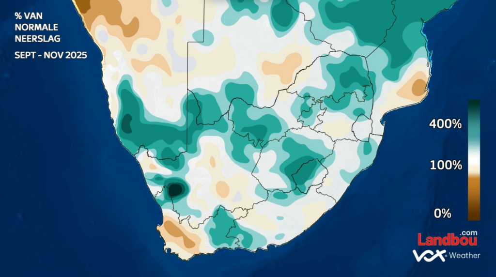
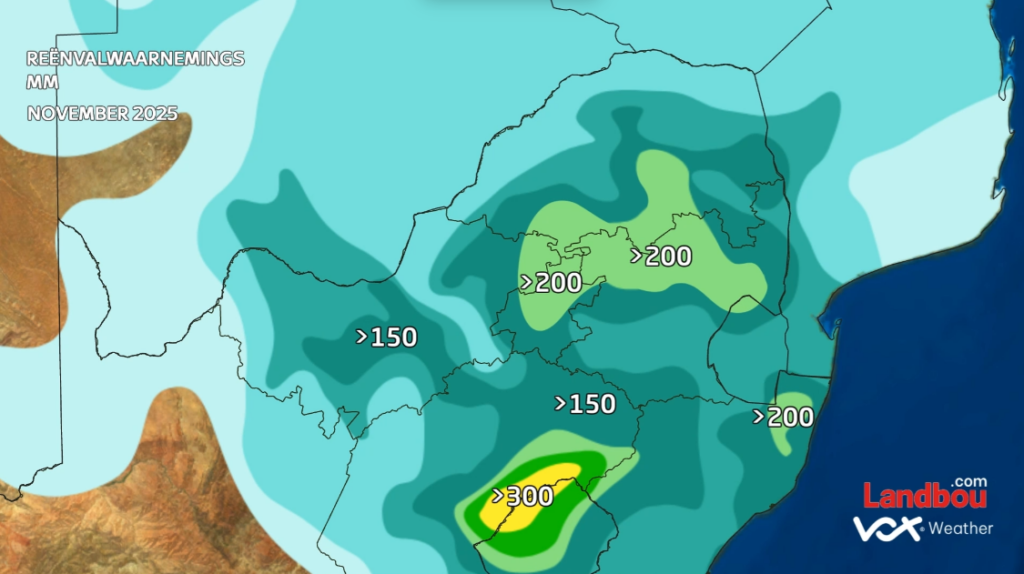
How Much Rain Actually Fell?
November did not just feel wet, it was exceptional. Large areas of the summer rainfall region recorded more than 150mm for the month, with pockets exceeding 200mm. To put this into perspective: Pretoria’s long-term November average is around 90 mm. Many regions received more than double their normal rainfall.
While the interior soaked, the Karoo, Eastern Cape and Western Cape experienced a notably drier spring, aligned with the persistent windier pattern that dominated the southwest.
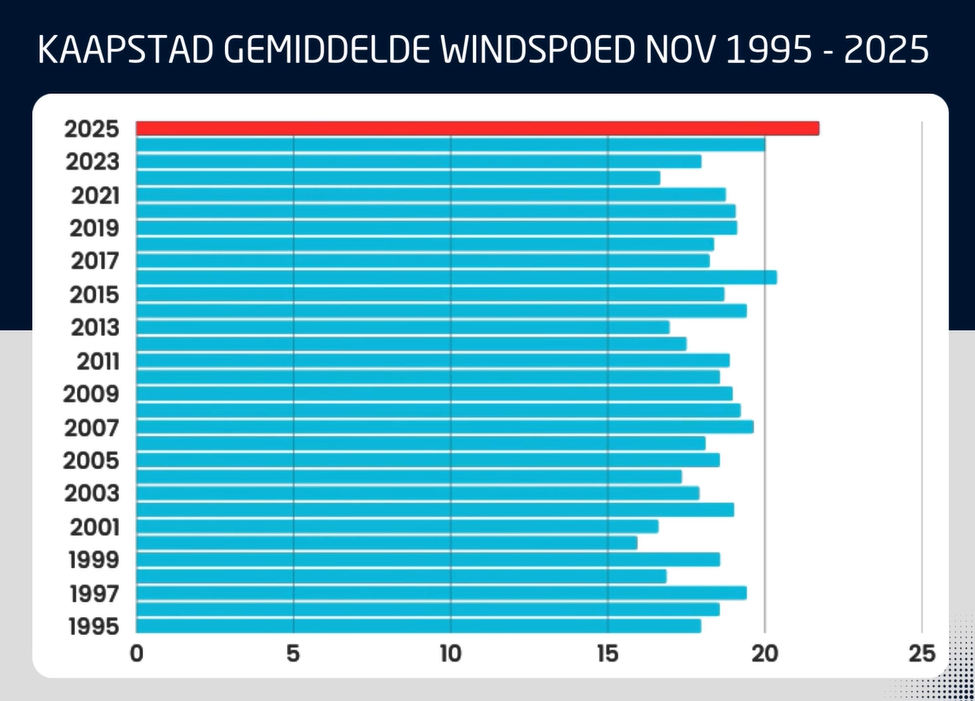
December Wind Outlook: More Gusts on the Way
November 2025 was confirmed as the windiest November since 1995 over the Western Cape based on 30-year wind-speed averages.
Unfortunately for Capetonians, the models show continued above-normal windiness in December.
This raises wildfire danger even further heading into the heart of the festive season.
Dams, Climate Drivers and What is Shaping the Season
Dam levels remain high across the interior and are expected to climb further with continued rainfall. In contrast, dams in the Western and Southern Cape are dropping quickly, with some municipalities already preparing for potential water restrictions.
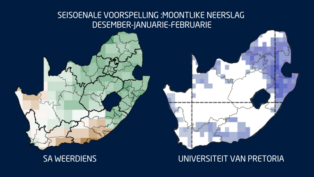
Globally, the climate system is reinforcing the wet-summer signal. We remain in La Niña conditions, and the Indian Ocean Dipole (IOD) is in a negative phase, a combination that historically supports above-normal summer rainfall for South Africa’s summer rainfall belt.
This means that December through February (DJF) still shows strong model agreement: a wetter-than-normal summer across the central and eastern parts of South Africa.
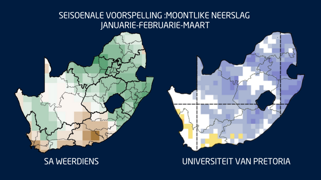
The only region where uncertainty remains is the Eastern Cape, ironically one of the provinces most in need of sustained rain. Seasonal guidance for January to March (JFM) keeps the same pattern: above-normal rainfall inland, with drier-than-normal tendencies persisting over parts of the Southern Cape.
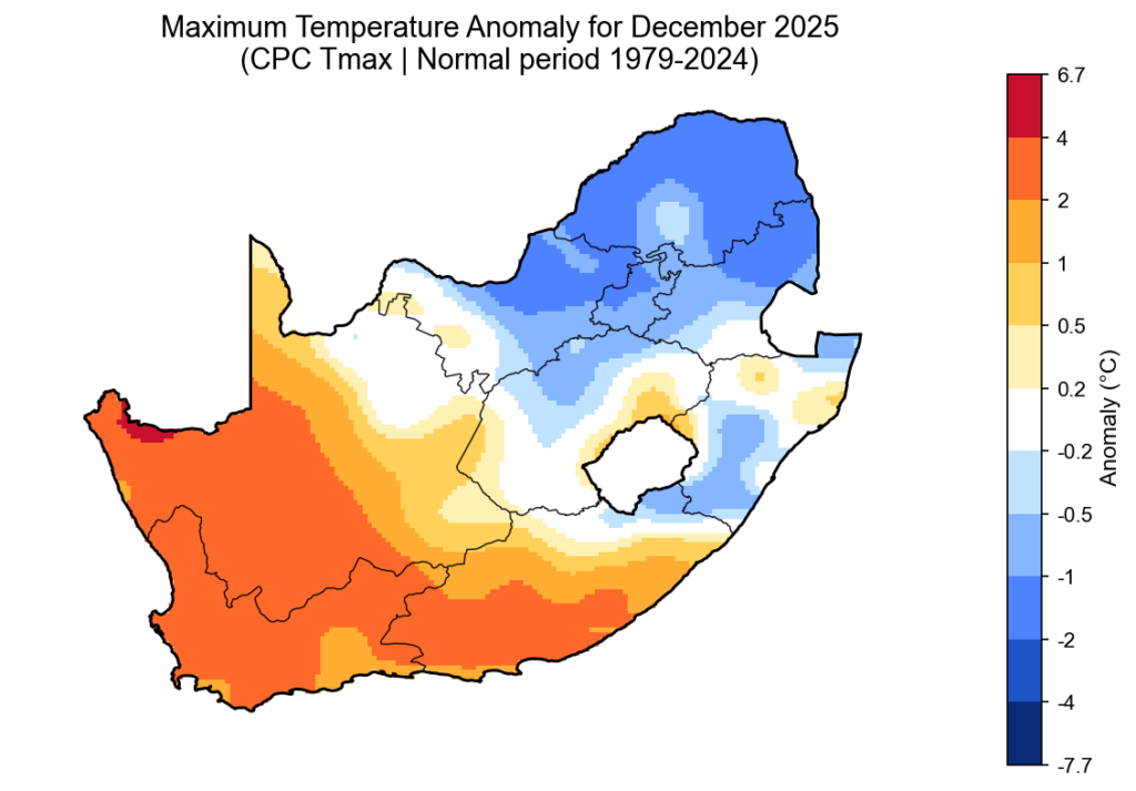
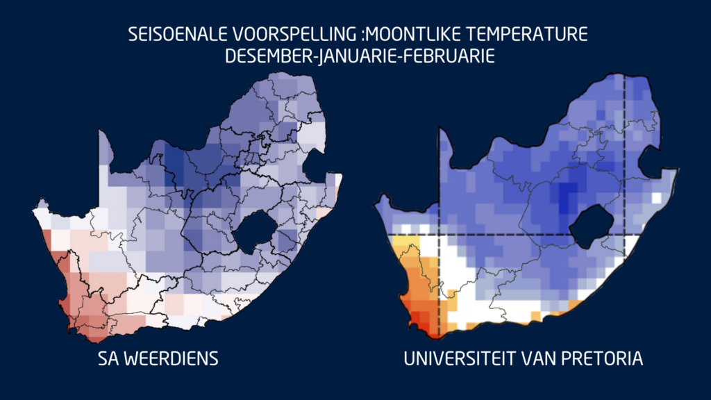
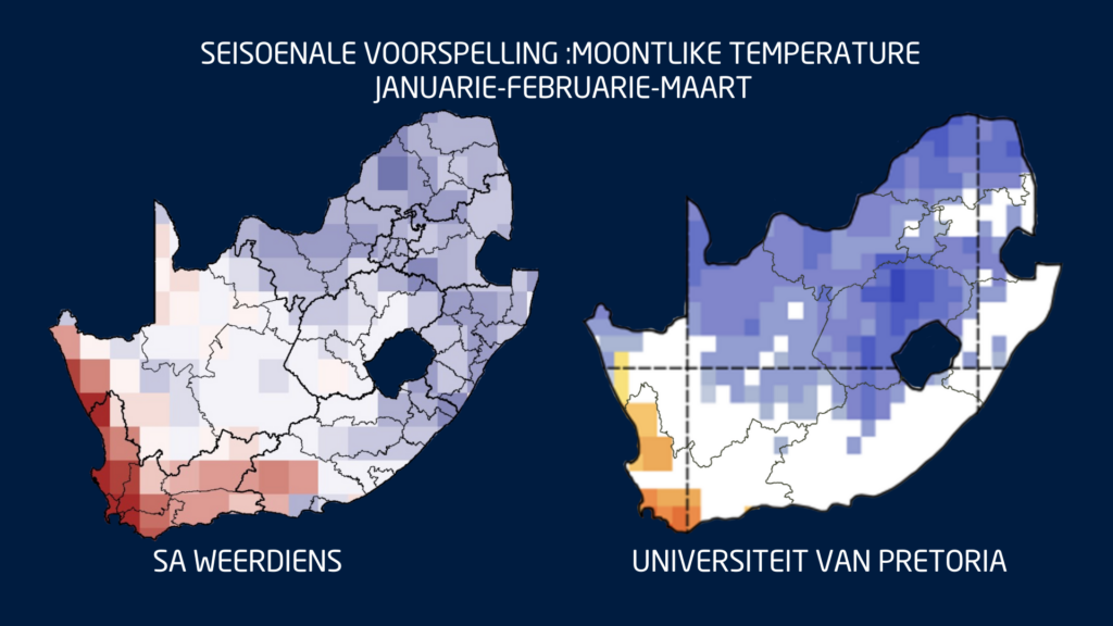
Temperatures: Cool in the East, Very Hot in the West
Where rainfall increases, maximum temperatures are expected to trend lower. Much of the summer rainfall region may see cooler-than-normal daytime temperatures through summer and early autumn.
However, the Western Cape, Northern Cape and Namakwa can expect very hot, windy conditions, especially toward the end of summer and into early autumn, a period when fire danger typically peaks.
What to Expect Week to Week
Short-term and sub seasonal models show a continued pattern of:
Repeated thunderstorm activity over the central and eastern interior;
Occasional heavy rain and local flooding;
Persistently gusty southeasterly winds in the southwest; and
Episodic heatwaves in the western interior
Farmers, disaster managers and residents should prepare for a summer with sharp contrasts: regular storms and good rain inland, and ongoing heat and fire risk in the west.
And finally a quick note to close off the year:
The Vox Weather ladies will be on annual leave for the festive season, but Vox Weather followers will still receive the daily weather maps throughout the period.
And so from Annette and Michelle: Wishing you a wonderful holiday period – travel safely and know that Vox Weather is always here to help you with your planning and continue ‘putting the WE back into Weather’!