We saw eight weather warnings in place recently as a second, and stronger, cold front moved over the south-western Cape in quick succession, bringing damaging winds and disruptive rain. Vox Weather Meteorologist Michelle du Plessis shares a short overview.

(Cover image courtesy of SABC News: Facebook)

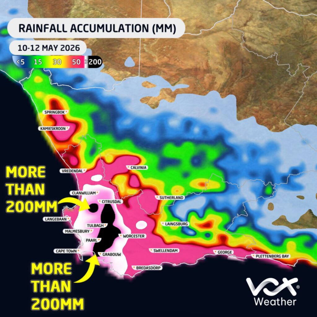
Two consecutive cold fronts moved across the south-western parts of South Africa this week (10 to 15 May), bringing widespread heavy rain, damaging winds and major disruptions across parts of the Western Cape.

The first cold front moved through on Sunday the 10th of May, followed by a second and stronger system on Monday the 11th. This second front brought the most intense weather, with heavy rainfall continuing into Tuesday the 12th across several areas.

Widespread Flooding and Disruptions

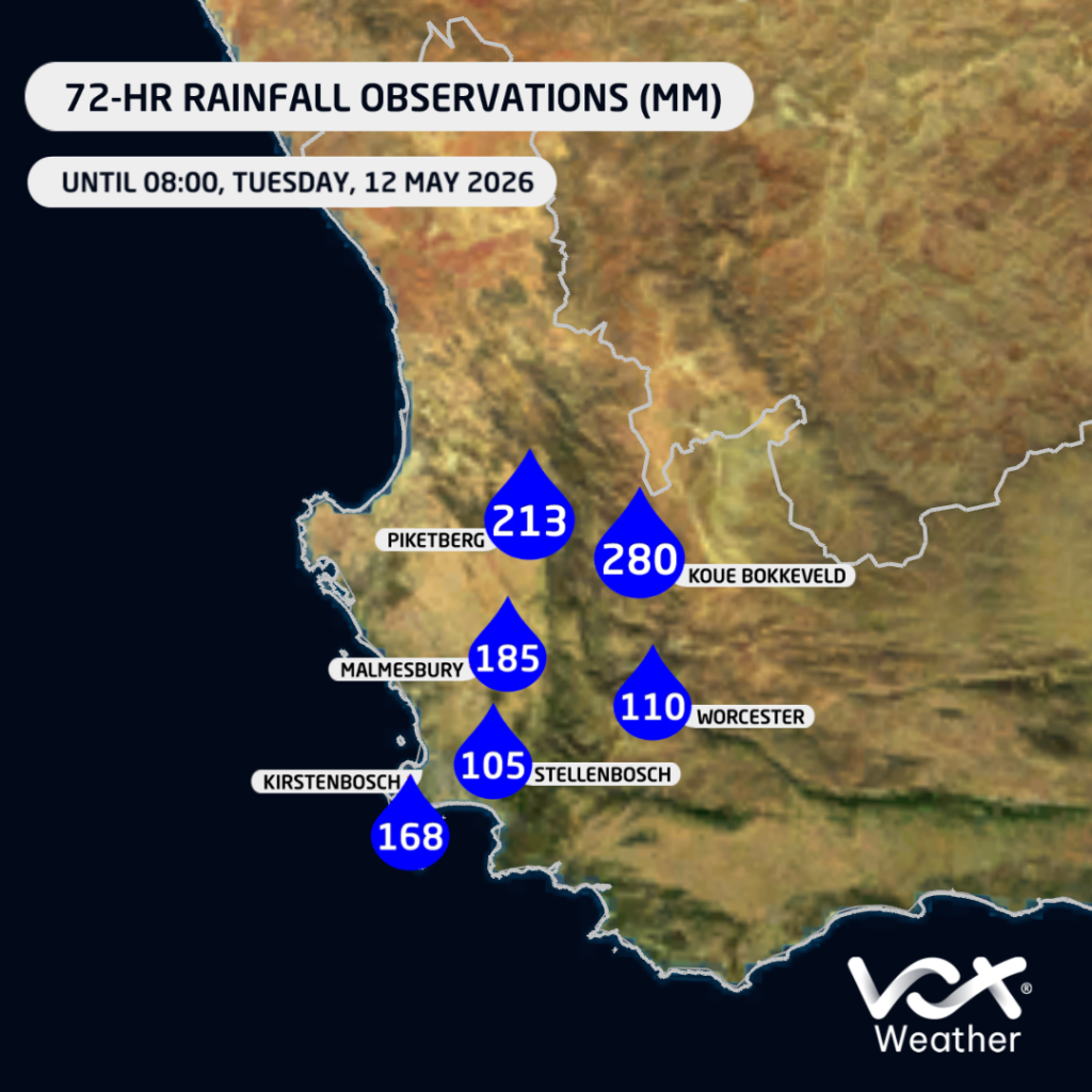
Rainfall totals were particularly significant across the western and south-western parts of the province. Several public reports indicate very high accumulations, including around 213 mm near Piketberg by Tuesday morning, with rain still continuing at the time of the report.

In the Koue Bokkeveld, between Ceres and the Cederberg, some areas reportedly received up to around 280 mm, with ongoing rain, road closures, power outages, limited internet access and cellphone tower disruptions being reported.

Some areas may even have received more than 300 mm, particularly some of the mountainous regions.

These very high totals led to widespread flooding and disruptions, with several schools in the Western Cape closed on Tuesday due to the severe weather conditions.
Damaging Winds

The heavy rain was not the only major concern. Damaging winds were also a significant component of this system.

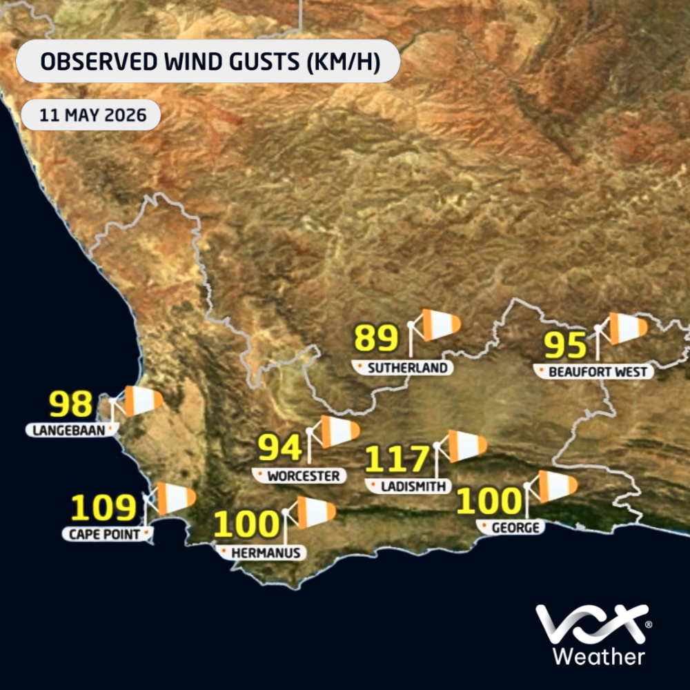
Official 24-hour wind gust observations for Tuesday showed gusts of 117 km/h at Beaufort West and Ladismith, 113 km/h at Ngqura, 109 km/h at Cape Point, 100 km/h at Sutherland, 98 km/h at Dohne, 94 km/h at Hermanus, 93 km/h at Laingsburg, and 91 km/h at both Cape Town AWS and Uitenhage.

Some private weather station reports indicated even stronger gusts, including a reported maximum wind gust of 142 km/h near Piketberg.

These strong winds contributed to widespread damage, including power outages, fallen trees, infrastructure damage and transport disruptions. The closure of the N1 towards Cape Town near Worcester was particularly significant, as it affected a major transport route into the city and likely disrupted the movement of goods and services. A number of flights from the Cape Town and George airports were also affected.

Nature Unleashed

This event highlights the tremendous potential impact of winter cold fronts when multiple systems move through in quick succession. The combination of saturated ground, persistent rainfall, strong winds and rough conditions can quickly lead to flooding, infrastructure damage, travel delays and power supply challenges.

Although strong cold fronts are a normal part of the Western Cape winter rainfall season, this event was particularly significant because of the intensity of the second front, the high rainfall totals over a short period, and the widespread damaging winds.

Conditions are expected to improve from Wednesday as the second cold front moves away from the province. The latest forecast currently indicates dry conditions across most regions of the Western Cape for the rest of the week.
Did you ever notice how the increased winds in August in South Africa’s interior are closely linked to the seasonal transition from winter to spring?

Vox Weather Meteorologist Michelle du Plessis tells us more.

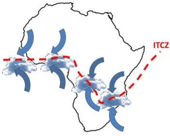
During winter, much of South Africa is dominated by a stable high-pressure system over the interior. By late winter, this high-pressure system begins shifting as the Intertropical Convergence Zone (ITCZ) also moves further south, while cold fronts from the southwest continue to pass across the country.

The interaction between these different air masses, namely colder, denser air from the west and warmer, lighter air building over the interior, creates a tighter pressure gradient. A tighter pressure gradient causes air to move faster, which is experienced as stronger winds. 

At this time of year, vegetation and soils are generally at their driest after months of limited rainfall. This allows dust and sand to be lifted more easily by the wind, and also creates ideal fuel for fires. The combination of dry vegetation, low humidity and strong winds makes it far easier for flames to spread rapidly and become uncontrollable. 

These conditions are a key reason why August is one of the worst times for any open burning, as even a small spark can quickly escalate into a runaway wildfire.

When Will the Rains Come?

The ‘August winds’ is generally a late‑winter feature that usually builds from late July, peaks through August, and fades during early to mid‑September. Mechanistically, the windiness is driven because of strengthening pressure gradients between lingering cold fronts to the southwest and a warming interior.

In most years, the interior’s first spring showers arrive mid to late September, but they’re usually light and isolated. The true start of the rainy season, with consistent, useful rainfall, tends to occur from October into early November.

Recent research confirms a shift toward a later onset of rain, especially in Gauteng and surrounding areas. What was once expected in September now often only establishes in October or even November.

This trend is linked to climate change and ENSO cycles, with El Niño years delaying rain and La Niña favouring earlier onset.

The bottom line is that the spring rains are coming, but they’re running later than they used to.

As the frontal influence relax and low‑level moisture flux from the northeast strengthens, winds generally ease from their late‑winter peaks and thunderstorm days begin to appear.

A practical rule of thumb is a one to four week overlap or transition: the gusty late‑winter pattern tapers off in early to mid-September; the first weak convective events pop up mid‑ to late September; and finally more reliable rainfall usually arrives in October.

Are We Seeing a Change in the Beginning of the Seasonal Spring Rains?

The short answer – in Michelle’s opinion – is yes.

She believes that there has been a change in the beginning of the seasonal spring rains in South Africa in recent times.

It matters because:

  • Rainy seasons are arriving later, shortening the wet window: A study across southern Africa confirms that the wet season is starting later, which also means shorter rainy periods and lower overall rainfall in many regions.
  • Climate change is a major culprit: Longer-term climate projections, especially under high emissions scenarios, suggest that shifts in global rainfall timing are already underway. In southern Africa, these shifts are tied to delayed wet-season starts, likely influenced by warming trends and changes in atmospheric circulation.

The Role and Effects of Fire

In the Western Cape, fire is essential for fynbos regeneration. In the interior grasslands and savannas, fire also plays an important ecological role, but timing and intensity matter.

Well-timed, cooler burns (usually done controlled, under calm, moist conditions) help remove old grass, stimulate new growth, and control bush encroachment.

However, August fires driven by strong winds are often too hot and fast, making them more destructive than beneficial. These fires can damage soil, kill recovering vegetation, and destroy grazing land.

So while fire is natural and even necessary in some ecosystems, the August fire season in the interior is more risky than helpful, especially when fires are uncontrolled and fuelled by dry, windy weather.

What Does This Mean on the Ground?

Farmers, planners and residents relying on spring rains can no longer count on September showery starts. In practice, October is fast becoming the more dependable month for meaningful rainfall, especially across Gauteng and the interior.

The bottom line?

Yes, spring rains are shifting later in South Africa. Research confirms that it’s happening, and that climate changes are steering the trend.

  • Recent studies show that the later start to the rainy season is linked to a combination of climate change and natural climate patterns.
  • Climate change is shifting weather patterns globally, including when and how rain falls in South Africa. Warmer temperatures affect how long dry seasons last and delay the arrival of reliable rain.

El Niño and La Niña also play a role. El Niño years tend to bring later and weaker rains, while La Niña often brings earlier and wetter conditions. We are expecting a weak La Niña to develop by summer, which may result in above-normal rain in the summer over the summer rainfall regions.