
We take a look with Vox Weather.
We’re definitely deep into cold weather season in South Africa, so we thought it would be a great idea to sit down with Vox Weather and find out what we can expect from Winter 2025.
Why not grab a cup of something hot to drink and see what Vox Weather Meteorologist, Michelle du Plessis, has to say to help us stay prepared?
Q: Please clarify the rough timeline that we use in South Africa to define the winter season?
In South Africa, winter runs from June to August. However, cold weather can begin as early as mid-May and linger into early September. Meteorological seasons are based on calendar months and average annual temperature cycles, making them more consistent for record-keeping and climate analysis.
Q: What does a ‘normal’ winter weather spread look like across South Africa?
South Africa is climatically unique because it experiences both winter, summer and year round rainfall patterns. Let’s take a look, region by region.

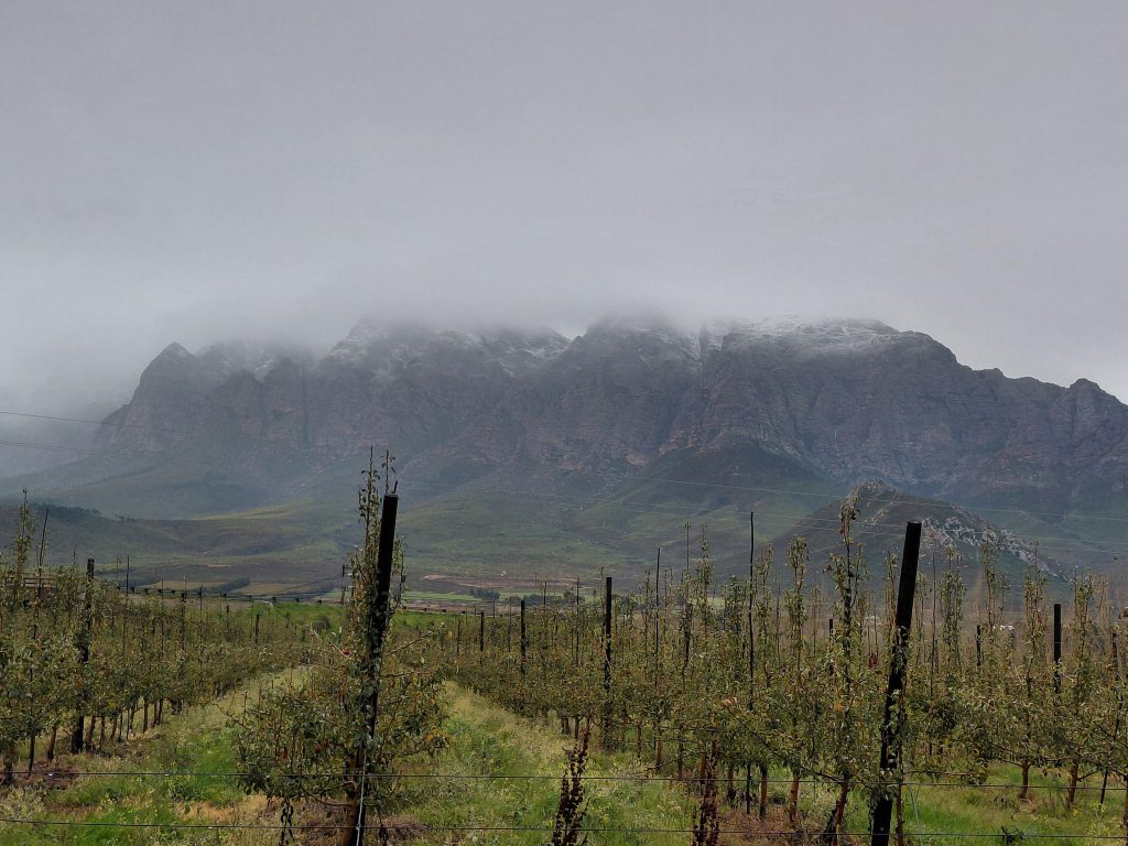
Western Cape: Winter Rainfall Zone
This is the only region in South Africa that receives most of its rain during winter (June – August).
- This happens due to mid-latitude cyclones or cold fronts that migrate northward during winter, sweeping across the south-western tip of the country.
- These systems bring cold, wet conditions to areas like Cape Town, the Winelands, Overberg, and parts of the Garden Route, and when the systems are strong enough, the cold also spreads as far north as Gauteng.
- The region often experiences multiple cold fronts per month, with days of strong wind and heavy rain.
Central Interior (Free State, North West, Northern Cape interior, parts of Gauteng and Highveld): Dry days and Cold nights
- Dominated by subsiding air from a dominant continental high-pressure system (Kalahari High Pressure System).
- These high-pressures suppress cloud formation and rainfall, leading to clear skies, dry air and very cold nights.
- Frost is common, and minimum temperatures often drop below 0°C.
KwaZulu-Natal Coast: Mild and Dry Winters
- The coastal belt remains warmer than the interior due to lower elevation and the warm Agulhas Current.
- Rain usually occurs behind a cold front due to a ridging high-pressure system, but berg winds (hot, dry winds) can cause temperature spikes in winter.
- Occasional morning mist or light rain may occur, but winters are generally comfortable.
Gauteng: Sunny but Cold Mornings
- Gauteng is firmly in the summer rainfall zone, so winters are mostly dry, cool and clear.
- Days are generally mild (17 – 22°C), but nights can be very cold with widespread frost.
- There is no significant winter rainfall unless an unusual cut-off low develops.
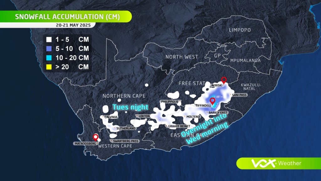
Eastern Cape Highlands, Southern Drakensberg & Lesotho: Cold with Snow Potential
- These high-altitude areas are the most prone to snowfall in South Africa.
- Snow is typically linked to strong cold fronts or cut-off low systems that bring enough moisture and drop freezing levels low enough for snow to fall.
- Towns like Rhodes and Barkly East, and the Mountains in Lesotho can see several snowfalls per season.
Limpopo and Mpumalanga Lowveld: Mild, Dry, and Stable
- These areas remain relatively warm, with pleasant daytime temperatures and dry conditions.
- Like Gauteng, they fall in the summer rainfall zone and receive little to no winter precipitation.
The Transition Zone: Where It Gets Complicated
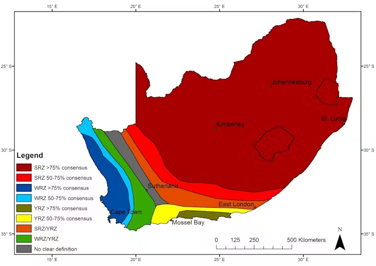
Research by Jennifer Fitchett and colleagues at Wits University (2019) revealed that while most experts agree that Cape Town is in the winter rainfall zone and Johannesburg is in the summer rainfall zone, the boundary between the two is highly disputed.
- Using over 60 rainfall maps from 1938 to the present, they found no consensus on where the two zones split.
- Areas like Sutherland are especially complex – some maps classify it as a winter rainfall area, others as summer rainfall, and some as year-round.
Climate Change Impacts
- Studies show that the boundary between rainfall zones is shifting southwards, driven by the southward retreat of the westerlies (wind systems responsible for cold fronts).
- This may explain recent droughts in the Western Cape (2015 – 2017) and may result in shorter, more intense winters in the future.
Q: With regards to a ‘normal’ winter weather spread in South Africa, are you anticipating any particularly unusual weather for winter 2025?
Winter remains one of the most difficult seasons to forecast in South Africa. For winter 2025, weather models are offering mixed signals, and there’s currently no strong consensus on what to expect. Some early forecasts suggest slightly wetter conditions in the far southwest, while others lean toward a drier interior. But overall, there’s no clear indication of a highly unusual winter.
In the Western Cape, where South Africa receives most of its winter rainfall, the key drivers are mid-latitude cold fronts and cut-off low-pressure systems – not El Niño or La Niña. The strength and frequency of these systems vary from year to year and are difficult to predict far in advance.
Long-range weather models often struggle to capture these systems accurately, especially when there’s no strong global climate signal influencing the region. While the El Niño-Southern Oscillation (ENSO) is currently in a neutral phase, this has little bearing on the Western Cape, making short-term forecasting the most reliable way to prepare for the season.
Even in a ‘normal’ winter, cold snaps, widespread frost, or periods of intense rainfall can still occur when the right weather patterns line up. So, while there’s no strong evidence yet pointing to a particularly unusual winter in 2025, it’s a season where conditions can shift quickly. Staying informed with short-range forecasts is the best way to be prepared.
Q: Do you see any major red flags for the 2025 winter season?
One important point to keep in mind this winter is that we’re entering the season with higher uncertainty than usual. With weather models not in agreement and no strong climate drivers like El Niño or La Niña to guide long-term trends, conditions could shift quickly.
This means it’s especially important to:
- Pay close attention to short-term forecasts, particularly for cold snaps, frost, and strong cold fronts.
- Be prepared for sudden weather extremes, even if the broader seasonal outlook appears ‘average’.
- Watch for localised impacts, like flash flooding from intense frontal rainfall or damage from strong winds, especially in the Western and Southern Cape.
Also, increased climate variability means that traditional expectations of winter weather may no longer apply. What was once seen as unusual – like snow in unexpected areas, or sudden dry spells during the rainy season – is becoming more common as the climate shifts.
So, while we don’t yet see major red flags for winter 2025, the takeaway is clear: stay informed, stay flexible, and be ready for change.