What to Expect This Coming Season in South Africa
South Africans are generally a summer-loving nation, and our country is famous for its sunshine – an average of 2,500 hours of sun every year. With spring behind us and summer holidays officially just a few weeks away, Vox Weather Meteorologist Michelle du Plessis tells us more about what to expect from the weather – including the all-important chances of rain.
‘Springing’ into Summer
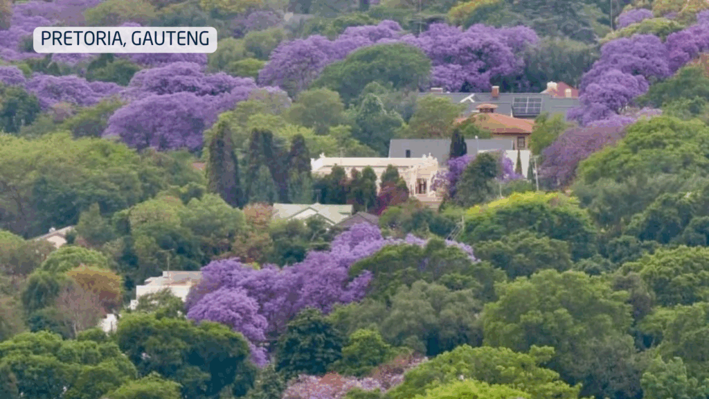
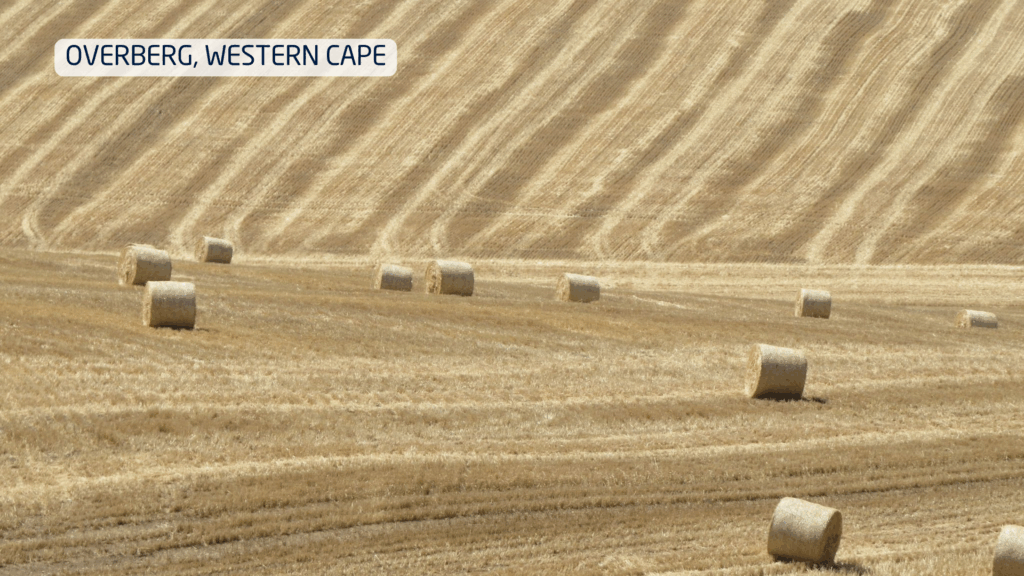
October is the time of year when the jacarandas are in full bloom and Pretoria literally turns purple! In the Western Cape it’s harvest time, and farmers are generally grateful for the drier conditions which allow them to finish their harvests on time.
The season starts with the characteristic berg wind conditions, and history was made on the 23rd of October when the South African Weather Service’s (SAWS) weather station in East London, which has been measuring for ten years, recorded its highest temperature yet for October at 41.4 degrees Celsius!
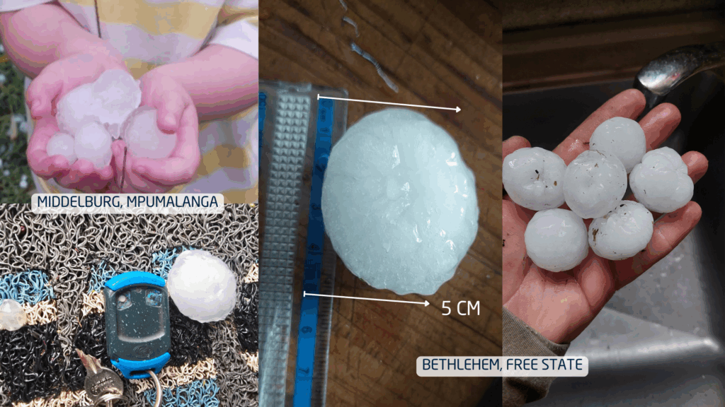
Throughout the month we saw spring showing its true nature. Several intense thunderstorms with hail were reported over large parts of the interior. By the beginning of November, Limpopo, Mpumalanga and the Free State had all experienced occasions where the hail was as large as golf balls!
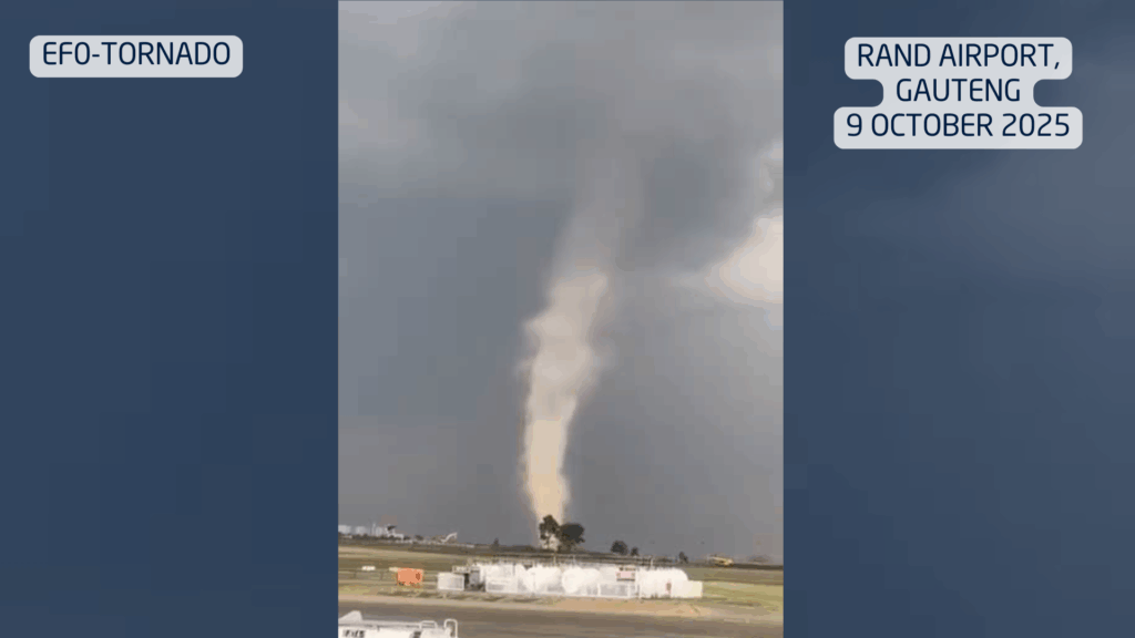
Transitional seasons like spring are known for their extremely unstable atmosphere. When warm, moist air from the northeast clashes with cooler, drier air from the west, then you get the perfect recipe for thunderstorms – and sometimes even tornadoes. On the 9th of October, for example, an EF0 tornado was confirmed near Germiston in Gauteng, with winds of more than 100 km/h being recorded (an EF0 tornado is the weakest category of tornado on the Enhanced Fujita (EF) scale, with wind speeds between 105 to about 140 km/h).
By the end of October the weather turns wet, with heavy rain over the central and north-eastern parts of the country. A farmer near Wesselsbron, Lourens, measured nearly 100 mm in just 24 hours, and in Frankfort there were reports of flooding.
The Percentage of Normal Rainfall for Spring
Looking back at where and how much rain has fallen during September and October, we see that, as expected, it was a drier start to spring for the summer rainfall regions, except for a few wetter spots in Gauteng and Limpopo where a few intense storms earlier in the month produced good rains.
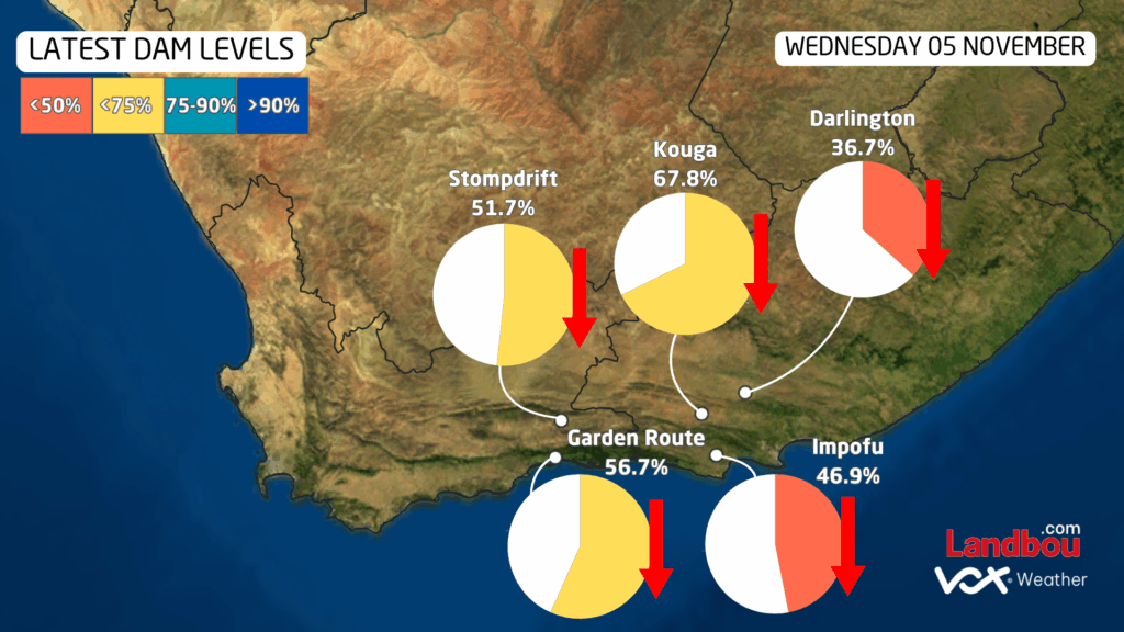
Our concern remains in the Southern Cape, where the map of percentage of normal rain for a period of 180 days from the start of winter into spring shows below normal rain for the southern Cape. Although this region is a year-round rainfall region, it remains dry, with the dams’ levels STILL decreasing.
State of Climate
ENSO:
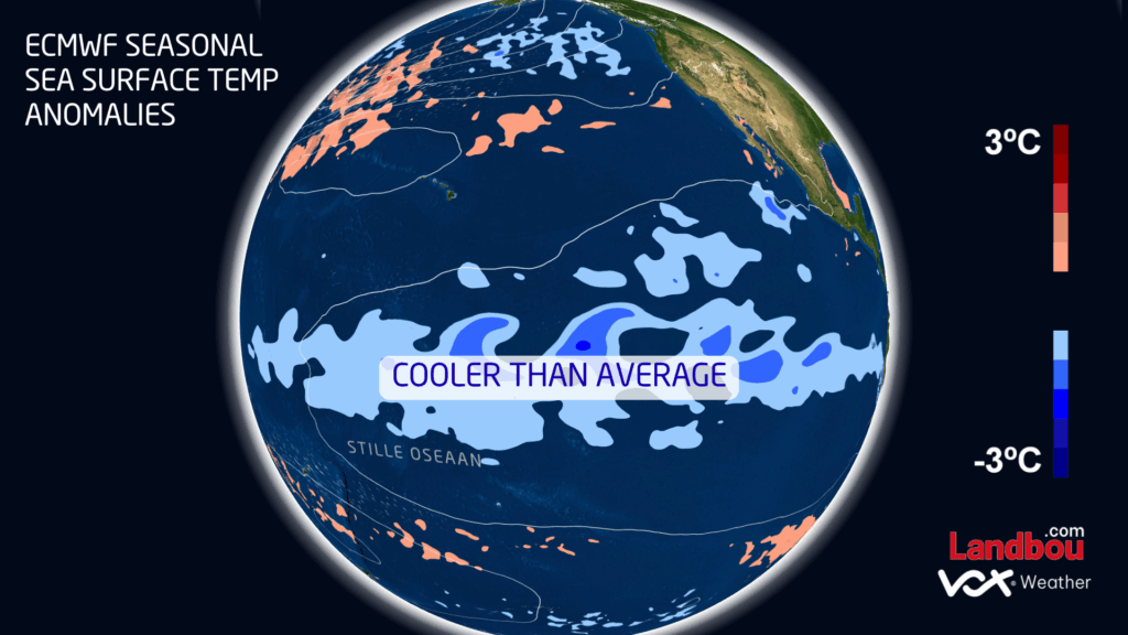
We are now officially in La Niña conditions, clearly visible in the blue shading that shows colder-than-normal sea surface temperatures in the Pacific Ocean. This typically points to a wetter-than-normal summer for South Africa’s summer rainfall regions – so yes, more thunderstorms and rain are on the way!
SOI:
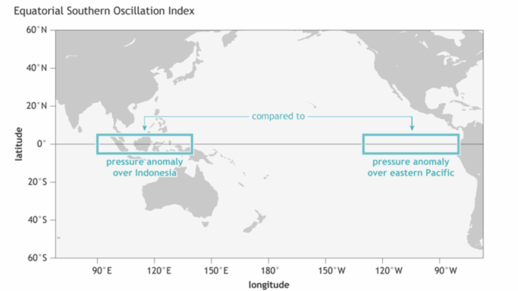
That said, this La Niña is expected to remain weak to moderate, and that is why we also have to look at other major climate drivers, such as the Southern Oscillation Index (SOI), which measures air-pressure differences over the Pacific Ocean, and has recently risen sharply into positive values – another clear sign that the atmosphere is supporting this La Niña pattern and helping to pull tropical moisture southwards.
IOD:
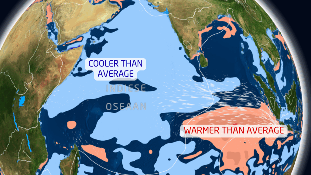
We also look at the sea surface temperatures over the Indian Ocean, with reference to the Indian Ocean Dipole (IOD). This measures the difference in sea surface temperature between the western Indian Ocean (near East Africa) and the eastern Indian Ocean (near Indonesia/Australia).
The Indian Ocean Dipole (IOD) is currently in a strongly negative phase – one of the most notable in the modern period. Waters near East Africa are cooler than normal and waters near Indonesia are warmer than normal. This helps push more moisture towards southern Africa, especially early in summer.
With a weak to moderate La Niña now established and supporting signs from other climate drivers, it looks promising for more widespread summer rainfall over large parts of the country.
But what do the models say?
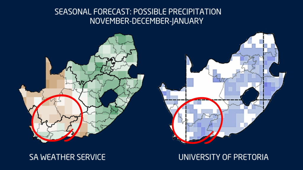
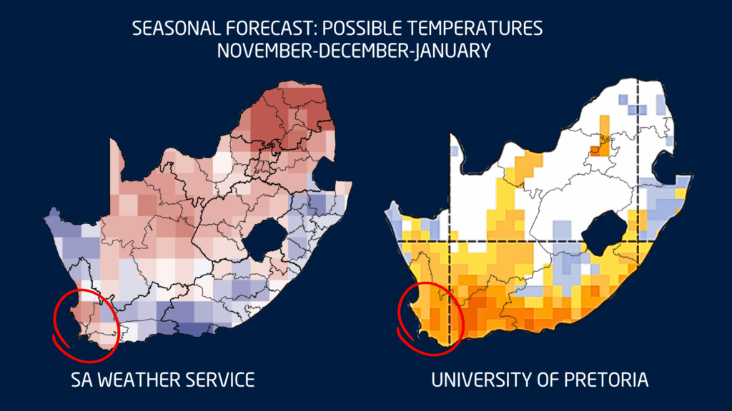
Seasonal Forecast: November, December, January
Both the University of Pretoria and the South African Weather Service (SAWS) indicate that the last month of spring and the first two months of summer are likely to bring above-normal rainfall over large parts of the summer rainfall regions.
They do not, however, agree on the expected rainfall in the Northern Cape, Karoo and southern Cape. According to SAWS, generally drier conditions are expected in that area, while the UP models indicate above-normal rain. Vox Weather therefore advises weather watchers not to rely too heavily on the long-term models for those regions, but rather keep a close eye on the short-term forecasts.
As far as temperatures are concerned, there is also not much agreement between the two forecasts. The only region where they do agree is over the south-western Cape, where warmer conditions are expected. This usually goes hand in hand with windy conditions and a high fire danger, which farmers and communities should please keep in mind.

Whether you’re in agriculture, planning a summer holiday, or simply trying to keep your garden alive: stay informed, plan ahead and enjoy the summer weather that still lies ahead – both rain and shine.
Remember that Vox Weather is always here to bring you forecasts and other information about the weather in our beautiful country!