After the total lunar eclipse in early March this year, South African sky gazers will have another chance to experience the magical lunar eclipse phenomenon at the end of August!

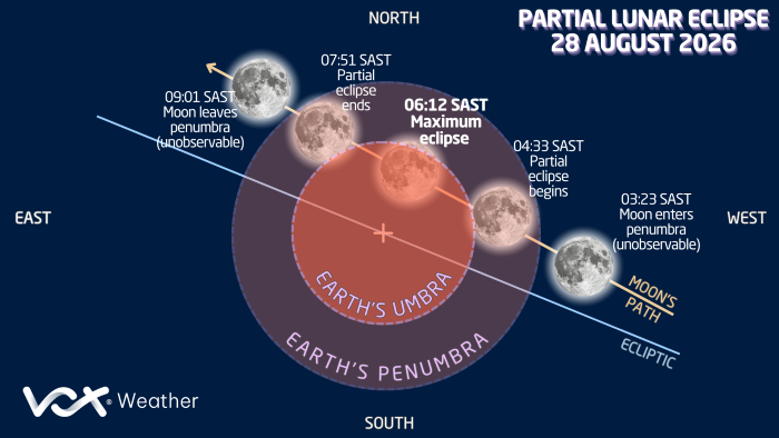
In the early hours of Friday morning 28 August, we can experience a spectacular deep partial lunar eclipse in which around 96 per cent of the Moon’s visible disc will be inside Earth’s dark shadow at maximum eclipse. Although it will not technically be a total lunar eclipse, it may look very close to one.

Vox Weather Meteorologist Michelle du Plessis tells us everything we need to know, including the all-important weather forecast details.

What is a Lunar Eclipse?

The first point to note is that a lunar eclipse can only happen during a full moon.

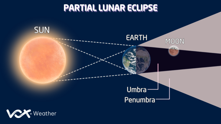
A lunar eclipse happens when the Earth moves between the Sun and the Moon, causing Earth’s shadow to fall across the Moon.

In simple terms:

  • The Sun shines towards Earth.
  • The Moon moves behind Earth.
  • Earth blocks some of the sunlight that normally lights up the Moon.
  • As a result, part or all of the Moon becomes darker.
  • When all of the Moon becomes darker, we have a total lunar eclipse.

Is This a Total Lunar Eclipse?

The eclipse on 28 August will be a deep partial lunar eclipse, and not a total lunar eclipse.

This means that most of the Moon will enter Earth’s darkest shadow, known as the umbra, but a small part will remain outside it.

At maximum eclipse, about 96.2% of the Moon’s visible disc area will be inside the umbra. The eclipse has an umbral magnitude of about 0.93, meaning the umbra reaches across roughly 93% of the Moon’s diameter. These numbers describe two different measurements.


What Time Does the Eclipse happen in South Africa?

The eclipse takes place during the early morning of Friday, 28 August.

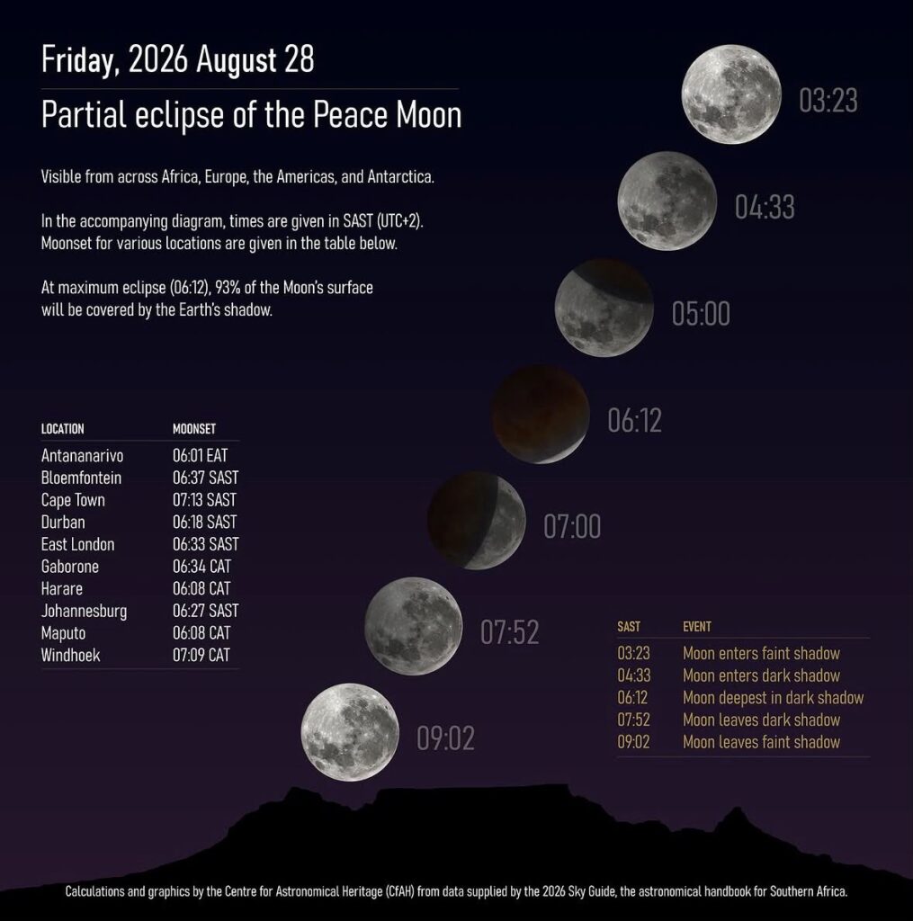
The main times in South African Standard Time are:

  • Penumbral eclipse begins: 03:23
  • Partial eclipse begins: 04:33
  • Maximum eclipse: 06:12
  • Partial eclipse ends globally: 07:51
  • Eclipse ends completely: 09:01

South Africans will not see the final stages because the Moon will set before the eclipse is over.

For most viewers, the best time to start watching will be from around 04:30.

What Happens During Each Stage?

Stage 1:

The eclipse begins at 03:23: The Moon first moves into the lighter outer part of Earth’s shadow, known as the penumbra. At this stage, the Moon will only become slightly dimmer. This change can be difficult to notice with the naked eye.

Stage 2:

The main eclipse begins at 04:33: The Moon then starts entering Earth’s darker central shadow, called the umbra. This is when the eclipse becomes much easier to see. A dark curved shadow will slowly move across the Moon, almost as though a bite is being taken out of it.

Stage 3:

Maximum eclipse occurs at 06:12: This is the deepest point of the eclipse. Around 96% of the Moon’s visible disc will be inside Earth’s dark shadow, leaving only a small portion brightly illuminated. This should be the most dramatic stage of the event.

Why Might the Moon Look Red?

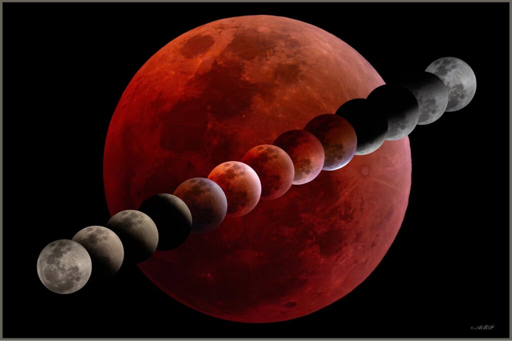
The Moon may take on shades of red, orange or copper during the deeper stages of the eclipse. This happens because some sunlight passes through Earth’s atmosphere and is bent into Earth’s shadow before reaching the Moon.

Earth’s atmosphere scatters much of the blue light, while more of the red and orange light passes through. It is the same basic reason that sunsets often appear red or orange.

So instead of the Moon simply disappearing into darkness, the eclipsed part may appear dark red, copper or brown.


Image below: Courtesy of Angus Burns Photography  Angus Burns Photography – Mullers Pass, Newcastle, KwaZulu-Natal, 7 September 2025

Where Should You Look?

Look towards the western horizon.

The Moon will be setting in the west while the eclipse is approaching maximum.

This means viewers should try to find:

  • An open area
  • A clear view towards the west
  • As few buildings or trees as possible
  • A location without mountains blocking the western horizon

This becomes especially important closer to 06:00, when the Moon will be quite low in the sky.


Which Parts of South Africa Will Have the Best View?

The western parts of South Africa will generally have the best view near maximum eclipse. This is because the Moon will remain higher above the horizon for longer in the west.

Approximate conditions at maximum eclipse at 06:12:

  • Cape Town: Moon around 11° above the horizon
  • Bloemfontein: Moon around 4° above the horizon
  • Pretoria: Moon around 2° above the horizon
  • Durban: Moon less than 1° above the horizon

Approximate moonset times are:

  • Cape Town: 07:12
  • Bloemfontein: 06:36
  • Pretoria: 06:25
  • Durban: 06:17

This means people in Cape Town and the western parts of the country should have a much better chance of seeing the Moon around maximum eclipse.

In the eastern parts of South Africa, viewers should start watching earlier rather than waiting until 06:12.


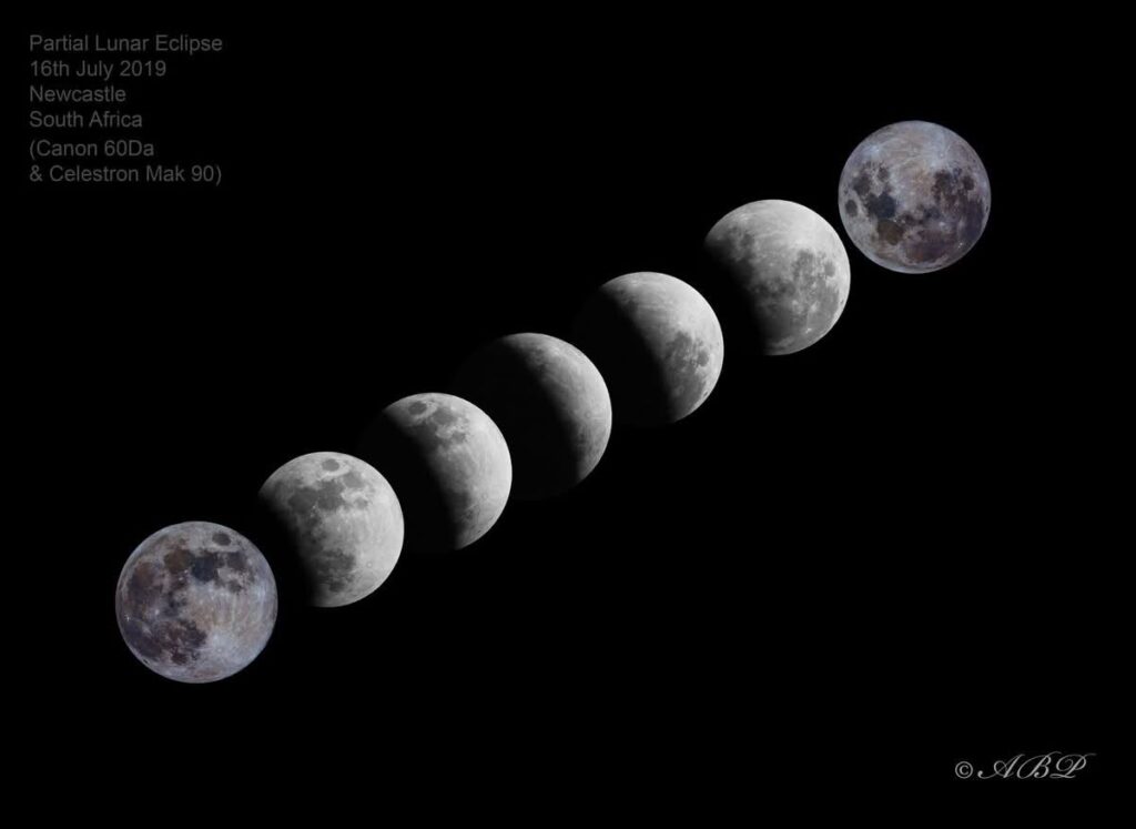
The image below, courtesy of Angus Burns Photography, reflects a partial lunar eclipse sequence on 16 July, 2019.

Why Will the Moon Be So Low?

The eclipse takes place shortly before sunrise in South Africa. As the morning progresses, the Moon will move lower towards the western horizon while the Sun approaches sunrise in the east.

So there are two things working against viewers later in the eclipse: the Moon becomes lower in the sky and the sky becomes brighter as sunrise approaches This is why the earlier stages of the partial eclipse could actually be easier to see in eastern South Africa than the moment of maximum eclipse.


Do You Need Eclipse Glasses?

No – a lunar eclipse is completely safe to look at with the naked eye. You do not need eclipse glasses because you are looking at the Moon, not directly at the Sun.

What Could Make the Eclipse Difficult to See?

Weather will be the biggest factor.

Even if skies are mostly clear, the Moon will be low near the western horizon, which means conditions close to the surface could make viewing difficult.

Things to look out for are cloud cover, low cloud, fog, haze and mountains or buildings along the western horizon. The eastern parts of the country will be particularly sensitive to poor visibility because the Moon will be extremely low by maximum eclipse.


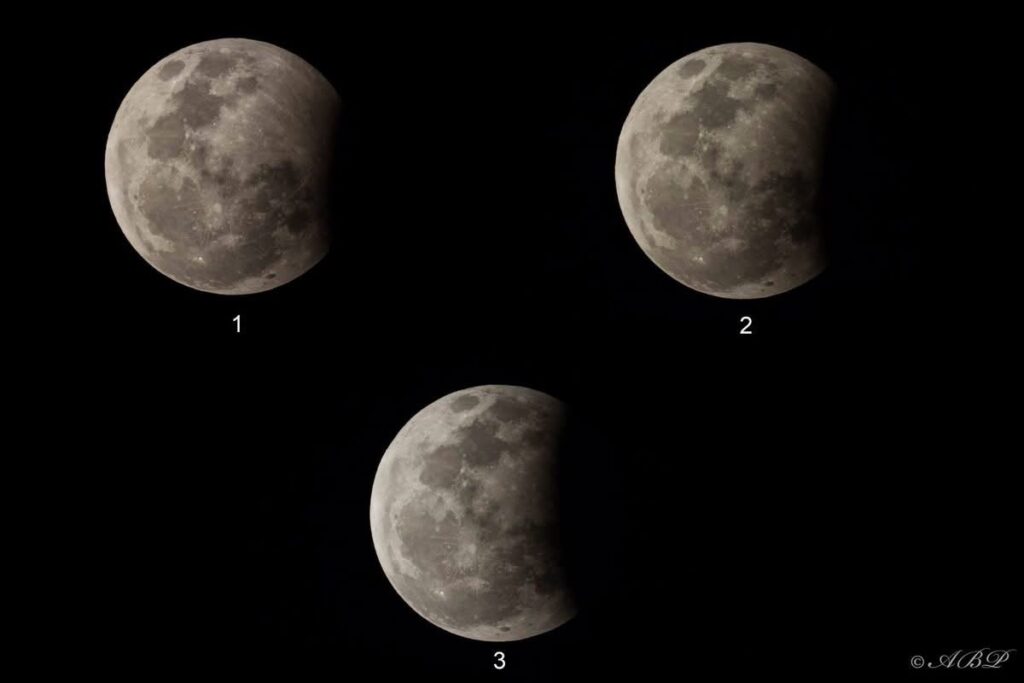
The image below, courtesy of Angus Burns Photography, shows phases of a partial lunar eclipse that took place in 2017.


Weather Outlook for SA’s Partial Lunar Eclipse

South Africans hoping to catch a glimpse of the partial lunar eclipse early on Friday morning, 28 August, will experience very different viewing conditions depending on where they are in the country.

Cloud cover will be the biggest deciding factor. While some areas are expected to have mostly clear skies, others could struggle with low cloud, fog and thicker cloud around the time of the eclipse.

Western Cape: 

  • Viewing conditions are not looking particularly favourable over the Western Cape. Mostly cloudy conditions are expected, with fog possible in places, particularly around Cape Town and the south-western parts of the province. This means the chances of seeing the eclipse are currently low in these areas.

Northern Cape: 

  • The interior of the Northern Cape currently has some of the best viewing prospects in the country. Little cloud cover is expected across much of the interior, giving residents a good chance of seeing the eclipse. Along the coast, cloudy conditions are expected, resulting in low viewing chances.

Eastern Cape: 

  • Conditions are more mixed over the Eastern Cape. Mostly cloudy skies are expected around Gqeberha, where viewing chances will be low. Conditions improve further east, with partly cloudy skies expected around East London, giving viewers a fair chance of catching the eclipse through breaks in the cloud.

Free State: 

  • Partly cloudy conditions are expected across parts of the Free State, including around Bloemfontein. Some breaks in the cloud are expected, giving the province fair viewing chances.

North West: 

  • Mostly clear to partly cloudy conditions are expected over much of North West. Overall, viewing chances look good, particularly where cloud cover remains limited during the early morning.

Gauteng: 

  • Gauteng is expected to be partly cloudy during the eclipse. Despite some cloud, enough clear breaks are currently expected to give much of the province good viewing chances.

Limpopo: 

  • Conditions are less favourable over Limpopo. Cloudy conditions are expected in places, with fog also possible, particularly towards the escarpment. This could significantly reduce visibility, resulting in low viewing chances.

Mpumalanga: 

  • Cloudy and foggy conditions are also expected in places over Mpumalanga, particularly along the escarpment. Viewing chances are therefore expected to be low in these areas, although locations farther away from the escarpment may experience some clearer breaks.

KwaZulu-Natal: 

  • KwaZulu-Natal currently has fairly favourable conditions, particularly along the coast. Mostly clear skies are expected along coastal areas, including around Durban, providing good viewing chances. The interior will be partly cloudy in places, with viewing chances depending on local cloud cover.

Where Are the Best Viewing Chances?

At this stage, some of the best viewing conditions are expected over the Northern Cape, North West and along the KwaZulu-Natal coast, with Gauteng also looking promising.

The Western Cape, Limpopo and parts of Mpumalanga currently have the poorest viewing prospects due to cloud and fog.

The Moon will also be very low towards the western horizon during the later stages of the eclipse. Even where skies are clear, viewers will therefore need an unobstructed view towards the west.

If the weather plays along, the early morning of 28 August should offer South Africans an impressive view as almost the entire full Moon slips into Earth’s shadow shortly before sunrise.

Happy sky gazing!

The infographic below is courtesy of the Centre for Astronomical Heritage and the 2026 Sky Guide.

A strong cold front is expected to reach South Africa on Sunday 09 August, followed by the development of a cut-off low from Monday. Vox Weather Meteorologist Michelle du Plessis rounds up the forecast for the Women’s Day long weekend and beyond.

Forecast confidence has improved for Sunday and Monday, with more than one model now indicating significant snowfall over parts of the eastern interior. However, Tuesday’s forecast remains uncertain.

Sunday 9 August

The cold front will move across the southern parts of the country, bringing cold, wet and windy weather.

🌧️ The heaviest rainfall is expected along the South Coast, including the Garden Route, and across large parts of the Eastern Cape. Up to 20 mm of rain could fall in some areas during the day.

❄️ Only light snowfall is currently expected over the mountains of the Western Cape, around Sutherland and the Nuweveld Mountains.

Heavier snowfall is likely over the mountains and high-lying areas of the Eastern Cape, where some locations could already receive around 10 cm of snow.

Snow will also begin spreading towards Lesotho, the southern Drakensberg and nearby high-lying areas.

Monday 10 August

A high-pressure system ridging behind the cold front will maintain cold, wet and windy conditions along the southern and eastern coastline, with another 10 mm of rain possible along parts of the South Coast.

Meanwhile, a cut-off low is expected to develop and bring heavier rain farther east.

🌧️ The heaviest rainfall is currently expected over KwaZulu-Natal, the Highveld and eastern Free State, where 15–30 mm could fall within 24 hours. Isolated showers and thunderstorms are also likely over Gauteng, Limpopo and North West.

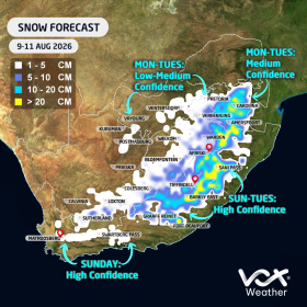
❄️ Both the European Centre for Medium-Range Weather Forecasts (ECMWF) and Global Forecast System (GFS) models are indicating the likelihood of significant snowfall over:

  • The Eastern Free State
  • The bordering areas of Free State and KwaZulu-Natal
  • The Mpumalanga Highveld, including areas around Ermelo, Dullstroom and Standerton
  • Lesotho and the southern Drakensberg
  • The KwaZulu-Natal Midlands, including areas around Underberg and Kokstad
  • High-lying parts of the Eastern Cape

⚠️ Major travel disruptions are possible. Van Reenen’s Pass and other mountain routes could close.
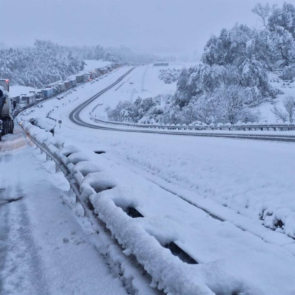

As seen during the September 2024 snow event, vehicles can become trapped for hours. Avoid unnecessary travel between Free State, KwaZulu-Natal and Mpumalanga on the public holiday and Tuesday.

Light snow remains possible over south-eastern Gauteng, including places like Delmas, Nigel, Benoni and Vereeniging.

Snow is not currently expected in Pretoria, and any snow falling with rain over Gauteng may struggle to settle.

Image: Snow at Van Reenen’s Pass, 2024 (image: The Citizen)

Tuesday 11 August

Tuesday’s rainfall and snowfall forecasts remain highly uncertain due to differences between the major forecast models.

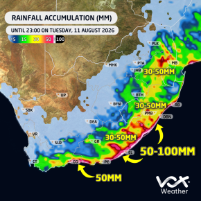
🌧️ The ECMWF model is indicating potentially heavy rainfall over eastern Limpopo and Mpumalanga, with isolated totals of up to 50 mm. It is also showing up to 50 mm along parts of the East Coast.

However, the GFS model is not currently showing the same level of heavy rainfall over the north-east.

❄️ The ECMWF model is indicating further snowfall over:

  • The Mpumalanga Highveld
  • South-eastern Gauteng
  • The Eastern Free State
  • Lesotho and the southern Drakensberg

In contrast, the GFS model currently limits Tuesday’s snowfall mainly to the southern Drakensberg.

We therefore cannot yet say with certainty how Tuesday will unfold.

Important Forecast Note

More than one forecast model is now in reasonable agreement regarding the expected rain, cold and snow on Sunday and Monday.

However, the exact position and strength of the cut-off low will determine where the heaviest rain and snow occur, particularly on Tuesday.

Even a small shift in the system could significantly change the forecast.

Vox Weather will provide another detailed update on Sunday as the system moves closer and forecast confidence improves.

One thing remains certain: A MAJOR COLD BLAST IS ON THE WAY! 🥶❄️🌧️

Did you know that Vox Weather has partnered with the ontbyteSAKE slot on KykNET on Saturday mornings? The Vox Weather dedicated weather segment is designed to enhance the programme’s weather service and deliver meteorological data to farmers, helping them to make more informed operational and financial decisions.

Vox Weather has built its following of more than 700,000 viewers on the foundation of its data and the depth of its analysis.

Annette Botha, meteorologist and Vox Weather presenter, has been delivering the weekday forecast for four years on Die Groot Ontbyt and is now bringing that trusted weather to the Saturday OntbySAKE audience.

The Saturday morning weather segment provides detailed meteorologist-produced forecasting, tailored for both the general public and the agricultural sector, and complementing the existing weekday slot on South Africa’s largest Afrikaans morning show.

The forecaster content is built specifically for the farming audience to be meteorologist produced, data verified and precise enough to support operational decision-making in the field.

The primary sponsor of the Saturday weather segment is Laeveld Agrochem, a leading agricultural company that supplies crop protection products, plant nutrition and precision farming technology to farmers.

ontbyteSAKE has been on air for 25 years with a broad audience, including significant reach into the South African farming communities. The Saturday morning slot offers meaningful insights around frost, rainfall and temperature patterns throughout the critical growing periods. It offers information that can help farmers plan ahead and make sound financial decisions based on trusted weather data.

Annette explains: “Our viewers in the agricultural sector need more than a percentage chance of rain. They need to know where the frost is going to fall, where the extreme rainfall is, what the temperature swings look like. That level of detail changes how a farmer plans their week.”

The segment is also accessible to all viewers, offering a clear four-day preview of expected weather conditions across the country. While the weather forecasts air on Saturday mornings during the ontbyteSAKE segment, an additional mid-week forecast will be published every Tuesday evening across the ontbyteSAKE and Laveld Agrochem social media platforms.

The midweek updates provide viewers with a weather outlook through to Friday, helping both the public and weather-sensitive industries to plan ahead.

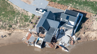
The 2025 / 2026 fires in the Western Cape, followed by the May 2026 floods, brought absolute devastation to some parts of the province, reminding us of the power of nature when it’s fully unleashed.

Vox Weather Meteorologists Annette Botha and Michelle du Plessis set out in the Subaru Crosstrek, in another episode of their ongoing quest to go ‘beyond the forecast’ – this time to find out more about the recent weather-related disasters. You can watch the video here – the visuals are a sober reminder of the power of nature.

Both the Western Cape’s Provincial Government and its citizens are still recovering from the recent devastating fires and floods, which affected more than 231,000 people and severely damaged farms, roads and critical infrastructure. Sadly, some people also lost their lives during these extreme weather-related events.

Annette and Michelle decided to look at these two very different weather extremes: first came the intense fire season, which was then followed just a few months later by severe flooding. They set out in the Vox Weather Subaru Cross Trek to talk to some of the people who had experienced these weather extremes on the frontline.

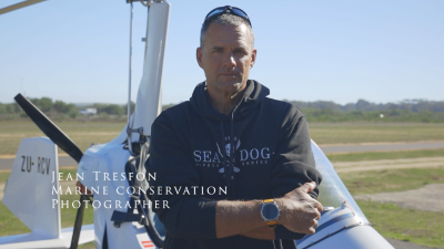
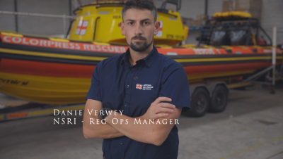
And so we hear from a helicopter pilot who spends most of his working life fighting fires from the sky; a marine conservation photographer who filmed some of the aftermath of the floods in a gyrocopter; and a regional operations manager for the National Sea Rescue Institute (NSRI), who was involved in some of the rescues during the flooding. Their stories, both individually and together, are inspirational and heart-warming.

Starting with the Fire Season

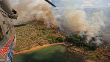
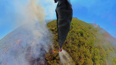
Hot, dry and windy conditions can very quickly turn a small fire into a deadly crisis. To understand what that looks like from the air, Annette and Michelle spoke to one of the fire pilots at Leading Edge Aviation, Mark Jackson, who runs the Lowveld-based company with his wife.

Mark explains: “We do a lot of aerial work, which includes some wildlife rescue work, but predominantly we’re involved in firefighting. For me, the defining feature of this recent fire season was how early and relentless it was. In 21 years of firefighting, I’ve never had to start so early.

“With the Gansbaai fires burning, our help was needed straight away. Working with our quick reaction force, we arranged to leave our normal base in the Lowveld and travel to the Western Cape to start suppressing those fires.

“From the first day, there were three solid ground teams, and the season never really slowed down from there.”

Mark clarifies that this fire season was more unpredictable and extreme than in recent years. He adds: “This was one of the busiest fire seasons I’ve seen. This was partly because we had very strong and warm berg winds. In this part of the country, they’re northerly winds that bring hot, dry air and this fire season, they were blowing at average speeds of around 40 to 50 kilometres an hour.

“These consistent winds were the strongest we’ve had in 30 years, and with winds like that, even the slightest ember or spot fire can blow up quickly, with the winds also, quite frequently, blowing all night. It helped to make the fire season unrelenting.”

Mark confirms that Leading Edge Aviation recorded 478 hours of firefighting and dropped about 8.2 million litres of water to quench the deadly fires.

He describes one particular moment that had an emotional impact on him, as follows: “We had a fire in the Wolseley–Tulbagh area that spread incredibly fast. It started next to a main road and was burning toward some wooden holiday cottages on flat ground. I circled overhead and signalled to the residents that the fire was coming. Watching people pack their belongings and leave in a hurry gave me goosebumps.

“We managed to put a line of water between the houses and the fire, and when we returned to refuel later, not one of those cottages had burned, and people were already putting their things back. It made the long distance we travel from home and the effort feel worthwhile!”

It’s incredible to think about the lives that Mark and his colleagues save – not only this year, but every fire season, due to the brave work they do in fighting the fires from the air.


From Dry Lands and Strong Winds to Saturated Grounds and Rising Rivers

After talking to Mark about the recent fires, Annette and Michelle then travelled in the Subaru Crosstrek to Morningstar Airfield near Cape Town to meet a pilot whose footage captured the flooding from the air.

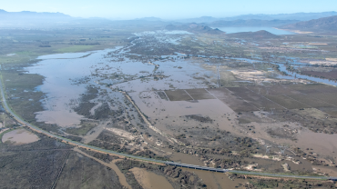
Jean Tresfon is a marine conservation photographer, pilot and cameraman who flew over the flooded areas recently. He shot footage from a gyrocopter – a type of small aircraft used for surveillance and aerial photography – to document the aftermath, which helped many people to see exactly how serious the flooding was.

Jean explains: “The main day of flooding took place the day before I could fly. By the time I flew the following day, the water levels had dropped a little, which actually made the damage easier to see. Buildings that had been underwater were now exposed, and the damage was shocking, with farm fields plastered with mud, and infrastructure and many buildings heavily damaged or completely destroyed.”

When comparing these floods to previous major Cape storms, Jean notes that, in terms of river height and the volume of water, this was the worst flooding since 1925. He says it’s plausible that the fire season contributed to the flooding, from the perspective of the fires burning through the vegetation that normally holds soil in place.

“When heavy rain falls soon after a fire, you get severe erosion. While the fires didn’t effectively contribute to the volume of water coming down the mountain, they certainly made the impacts worse, because vegetation and topsoil were washed away. For example, at Mitchell’s Pass near Ceres, the road was extensively damaged, with soil from burnt slopes coming down onto the road and nearby railway track, and so yes, in that sense, the recent fires played a role in the extent of the flooding.”

Jean notes that floods were common in the early 1900s and then rare for a while, and now we’ve seen notable events in 2008, 2023 and 2024, and again in 2026: “The pattern suggests these extremes are becoming more frequent, and the fires are definitely more prevalent than they used to be, and so preparation is more important than ever.”

It seems that we can’t pin a single storm or season directly on climate change, but we are seeing a more variable climate and more extreme events overall.


Rescue Operations During the Floods

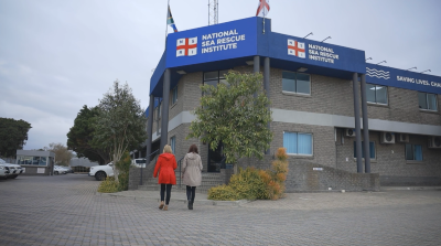
After listening to Jean’s information about the aerial views of the flooding, Annette and Michelle then went to the NSRI headquarters to learn more about how the recent flood rescue operations had unfolded on the ground. They spoke to Danie Verwey, who is one of the four regional operations managers for the National Sea Rescue Institute, and who reported that the rescue missions that took place were ‘hectic’.

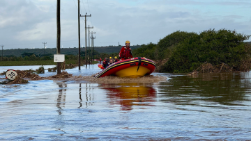
Danie says: “After the heavy rainfall led to severe flooding across the Western Cape, volunteers and crews responded rapidly across multiple scenes. By the time we were activated, we already had several stations responding to call-outs throughout the day.

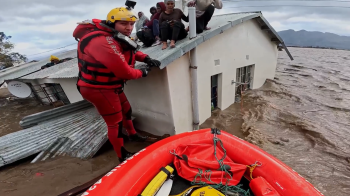
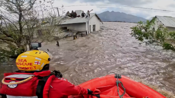
“One of the incidents people saw on social media was around Station 42, Kleinmond, responding in the Worcester and Rawsonville areas. The rescue crews really had to improvise: they couldn’t always reach casualties with boats, so they used anything they could find, including ladders, floating debris or anything that would get them to people stranded on roofs.”

Danie says there are many stories that stand out. “For example, in one case, crews scoped a house to see if anyone was trapped inside. They climbed onto the roof but couldn’t access the house through doors or windows because of the water, so they removed corrugated sheeting to enter from above.”

This kind of improvisation and bravery was common. If there is one main safety lesson for the public to learn from this event, it’s that if local authorities ask you to evacuate, you really should do so if you can!

Danie continues: “We know it’s not simple, and that you can’t always pack everything you love, but leaving when you’re advised to do so is usually the safest option. If you can’t reach higher ground, try at least to move out of the most affected area. Also, if you do evacuate, stick together in a group; it’s far easier for rescue teams to find groups than individuals.”

Annette notes: “From fire to flood, this all shows how quickly weather risks can change and how deeply they can affect lives, livelihoods and communities. That’s why we don’t stop at the forecast but instead aim to go beyond the forecast.”

Michelle concludes: “And from dry lands and strong winds, to flying over flooded fields and facilitating rescue missions, that’s another report from us on the harsh realities that the weather can help to unfold. We are thankful to Mark, Jean and Danie for sharing their experiences with us, as well as the incredible work that each of them does to share information and help to save lives.”

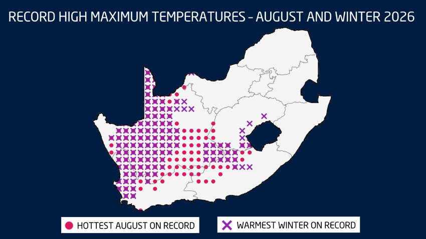
Winter in South Africa runs officially from the beginning of June to the end of August – that is, from a meteorologist’s point of view. So even if we get icy weather in May, we’re still only ‘officially’ in Autumn! Meteorological seasons are based on calendar months and average annual temperature cycles, making them more consistent for record-keeping and climate analysis.

And so, as we move towards mid-July and the halfway mark of winter, Vox Weather Meteorologist Michelle du Plessis gives us an update on winter so far, and what the coming months might bring.

June Rainfall and Temperature Patterns

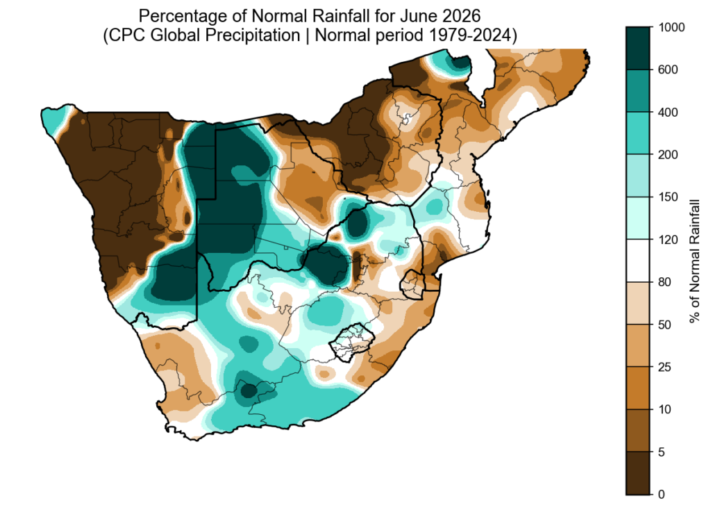
June rainfall anomalies show that some seasonal models correctly picked up on the drier start to winter over the far west. However, June was not dry everywhere. More than one cut-off low system brought above-normal rainfall to parts of the summer rainfall region and the Southern Cape. Southern Namibia also stood out, with some areas receiving up to six times their normal monthly rainfall.

Although it may have felt cold at times, June was surprisingly warm overall. Across large parts of South Africa, both morning and daytime temperatures were above normal. Provincial temperature analysis shows that the Free State, North West, Northern Cape and KwaZulu-Natal recorded their warmest average June temperatures since 1979, and possibly their warmest June on record.

El Niño Is Here

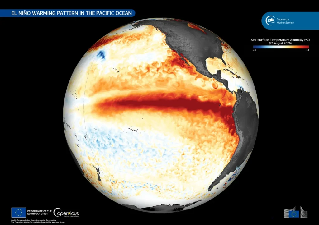
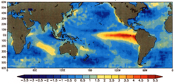
El Niño is currently one of the biggest talking points in weather and agriculture. But it is important to remember that El Niño is not something that will suddenly ‘hit’ South Africa – it has already started developing over the Pacific Ocean.

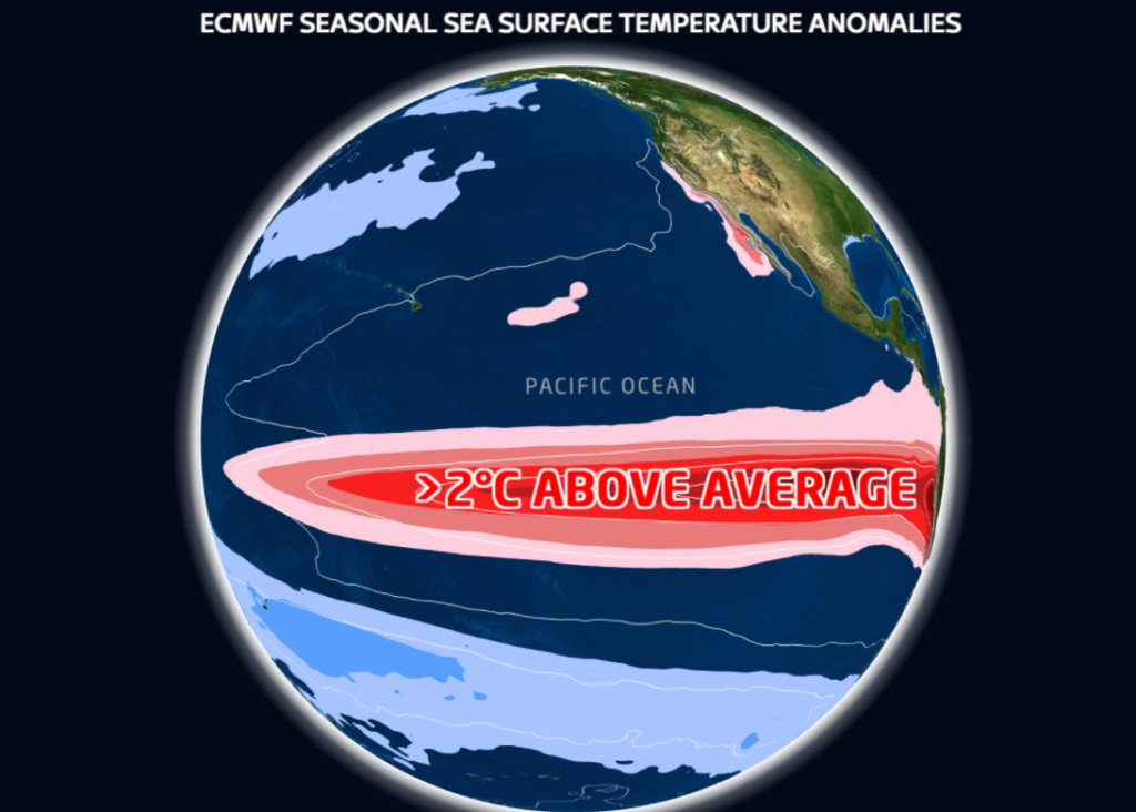
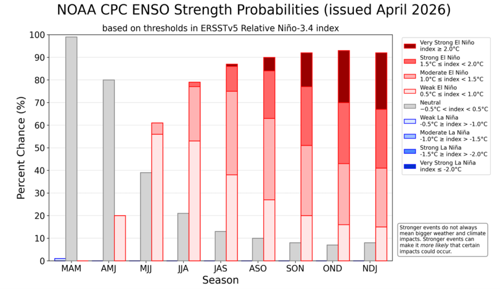
We are currently in weak El Niño conditions, meaning sea surface temperatures over the central and eastern Pacific Ocean are warmer than normal. El Niño is expected to continue through winter and spring, with an 81% chance of developing into a very strong event during October to December 2026. This would rank it among the largest El Niño events in the historical record dating back to 1950.

A very strong, or so-called ‘super’ El Niño, usually refers to an event where sea surface temperatures across large parts of the central and eastern Pacific remain more than 2°C above normal for an extended period.

Does A Strong El Niño Always Mean Drought?

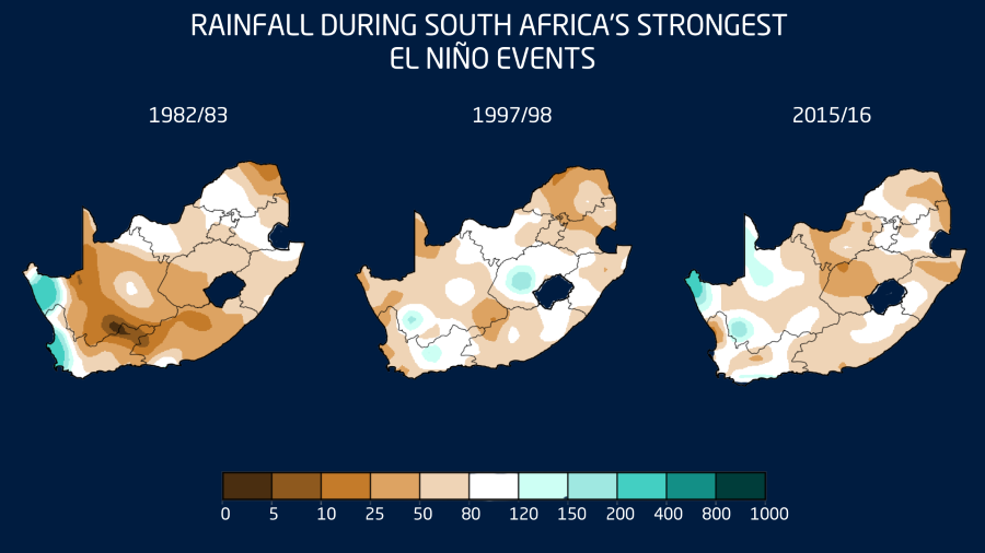
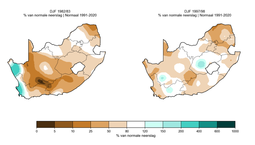
No. South Africa has experienced strong El Niño events before, and they have not all produced the same outcome. During strong El Niño events in the 1980s and 1990s, many areas did experience drier-than-normal conditions, especially over the summer rainfall region. However, there were also parts of the country that still received normal or even above-normal rainfall, including parts of North West and the Free State during the 1997/1998 summer.

The major exception was 2015/2016. That was one of the strongest El Niño events on record and contributed to one of the worst droughts in modern South African history.

The key message is this: a strong El Niño does not guarantee drought. It increases the risk of drier-than-normal conditions, especially over the summer rainfall region.

A Better Starting Point Than 2015/2016

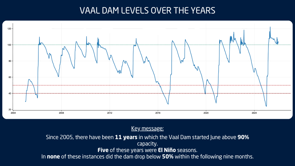
There is also some good news. Many dams are currently in a healthy state, and soil moisture looks better over large parts of the country than it did before the 2015/2016 drought.

The Vaal Dam is a good example. Since 2004, there have been 11 years where the Vaal Dam started June above 90% full, similar to this year. In all 11 of those years, the dam remained above 50% for the following nine months. Five of those years were El Niño seasons, including 2018 and 2023.

This does not mean we can relax, but it does give South Africa a stronger starting point if the coming summer does turn warmer and drier.

Seasonal Outlook: Winter Into Spring

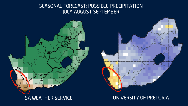
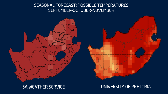
Looking at the rest of winter and the start of spring, both the SA Weather Service and University of Pretoria forecasts agree broadly on one thing: the far west is likely to remain drier than normal.

There are still indications of above-normal rainfall over parts of the interior, especially where cut-off lows or upper-air low-pressure systems may develop. This is a pattern we started seeing in June already, with weaker cold fronts over the Western Cape and more active upper-air systems over the interior.

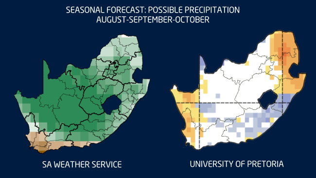
By late winter and early spring, the models begin to differ more noticeably. The SA Weather Service shows a possible wetter-than-normal signal over parts of the interior, while the University of Pretoria forecast is more mixed and even shows a drier signal in some areas.

This difference highlights the uncertainty that still remains. The atmosphere has not yet fully decided how it will respond to the developing El Niño.

Summer Outlook: Heat May Be the Bigger Risk

While below-normal rainfall remains an important risk, the biggest concern this summer may not only be drought, but extreme heat.

Most seasonal forecasts agree that South Africa can expect warmer-than-normal conditions from spring. This increases the chance of more frequent, longer and more intense heatwaves during the coming summer.

Higher temperatures also mean higher evaporation, increased water demand for crops and livestock, and greater pressure on soil moisture. When thunderstorms do develop, the extra heat and moisture can also help fuel more intense, isolated storms. So even in a season with a drier overall signal, heavy downpours, hail and localised flooding can still occur.

What Should Farmers and the Public Take from This?

  • Do not rely on one seasonal forecast alone. Seasonal forecasts give us an indication of the most likely scenario, but they are not exact predictions of what will happen on every farm.
  • Plan for a warmer-than-normal summer. This is currently the clearest signal across most climate models. Higher temperatures can increase water demand and heat stress for both crops and livestock.
  • Prepare for both extremes. A strong El Niño increases the risk of a drier summer, but it does not mean there will be no rain or storms. When the right conditions develop, thunderstorms can still become severe.
  • The good news is that there is still time. El Niño develops over months, not days. Regular monitoring, good planning and the use of short-term forecasts remain the best ways to manage risk.

We publish a new seasonal outlook every month on Landbou.com. Keep monitoring the latest forecasts, share this information with other farmers, family and friends, and use the time now to prepare for what the summer may bring.


Why it is still too early to make drought predictions for South Africa

After one of the better rainfall seasons so far across parts of South Africa’s summer rainfall areas, a new concern is starting to draw attention: the possibility of a strong, or even ‘Super’, El Niño later in 2026. This has already raised concern among farmers, agricultural businesses, water planners and other weather-sensitive industries. However, says Vox Weather Meteorologist Michelle du Plessis, it is important to approach the topic carefully.

While the chance of El Niño developing later this year is increasing, it is still too early to make direct drought predictions for South Africa. At this stage, the best message is one of awareness and preparation, not panic. We unpack this in the article.

What is El Niño?

El Niño forms part of the El Niño-Southern Oscillation, commonly known as ENSO. ENSO is a natural climate pattern linked to changes in sea surface temperatures and atmospheric pressure across the central and eastern equatorial Pacific.

During El Niño, sea surface temperatures in the central and eastern equatorial Pacific Ocean become warmer than normal. This warming can influence global weather patterns by shifting large-scale atmospheric circulation. 

In southern Africa, El Niño is often associated with a greater chance of hotter and drier conditions during the summer rainfall season, especially over the interior summer rainfall regions.

However, El Niño does not affect every country or every season in the same way. It also does not automatically mean that drought will occur.

What are the latest forecasts showing?

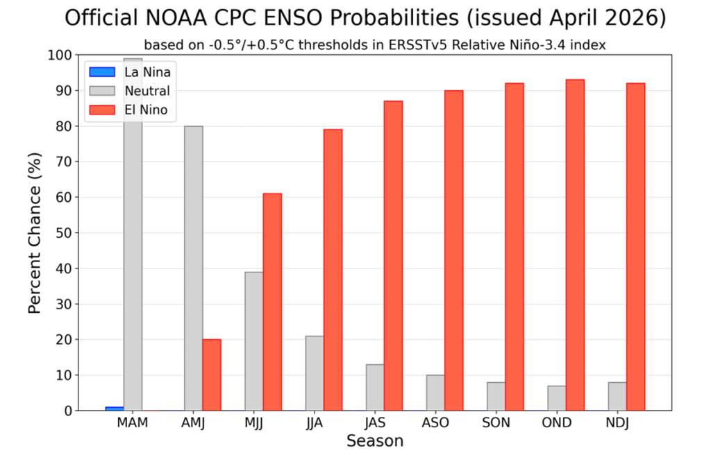
According to the latest outlook from the US Federal Agency, the National Oceanic and Atmospheric Administration (NOAA), ENSO-neutral conditions are currently present, but El Niño is likely to develop during May to July 2026. NOAA gives a 61% chance of El Niño emerging during this period and continuing through at least the end of 2026.

NOAA also indicates a roughly one-in-four chance that the event could become very strong later in the year, but notes that this depends on whether the atmospheric conditions over the equatorial Pacific continue to support further strengthening.

The World Meteorological Organization (WMO) has also highlighted that ENSO-neutral conditions are expected in the short term, while the probability of El Niño increases later in 2026. WMO’s earlier update indicated around a 60% chance of neutral conditions during May to July, with the chance of El Niño rising to around 40% during that same period.

Here at home, the University of Pretoria’s Seasonal Forecast Worx April 2026 update also points towards the possible development of a strong El Niño state towards the end of 2026.

This means there is growing agreement that El Niño may develop later this year, but there is still uncertainty about how strong it will become and how directly it will affect South Africa.

What does ‘Super El Niño’ mean?

The term ‘Super El Niño’ is often used in the media to describe an exceptionally strong El Niño event. In scientific discussions, a very strong El Niño is usually linked to sea surface temperature anomalies in the Niño 3.4 region reaching around +2.0°C or more.

However, ‘Super El Niño’ is not always used consistently. It can sound dramatic, and it can create the impression that severe drought is already guaranteed. That is not the case.

A strong El Niño increases the probability of certain climate impacts, but it does not guarantee the same outcome in every country. For South Africa, the strength of El Niño is important, but it is not the only factor that determines rainfall.

Too early to make drought predictions for South Africa

It is still too early to directly link the expected El Niño to a specific drought outcome for South Africa.

One reason is that ENSO forecasts are generally less reliable during the late autumn and winter months. Forecast confidence usually improves from around August and September, when the Pacific Ocean and atmosphere are more clearly coupled and the signal for the coming summer rainfall season becomes stronger.

This is especially important for South Africa, because the main ENSO-related impacts are usually felt during the summer rainfall season, from around October or November through to March. The current winter period is not expected to be significantly influenced by the developing El Niño signal.

For this reason, any strong statements about drought over South Africa should be treated with caution at this stage. It is more responsible to say that the risk of hotter and drier summer conditions may increase if a strong El Niño develops, but it is not yet possible to confirm the timing, severity or regional detail of those impacts.

South Africa’s rainfall is influenced by more than ENSO

Although El Niño is an important climate driver, South Africa’s rainfall is influenced by several other factors as well.

These include the position of high-pressure systems, moisture transport from the tropics and Indian Ocean, cut-off lows, tropical-temperate cloud bands, regional circulation patterns, sea surface temperatures near southern Africa, and shorter-term weather systems.

This means that even during El Niño years, rainfall can still vary significantly from one region to another. Some areas may experience long dry spells, while others may still receive important rainfall events.

It is also important to remember that only the summer rainfall regions of South Africa are typically more directly influenced by ENSO. The winter rainfall region, especially the Western Cape, is not affected in the same way during winter.

What can we learn from past strong El Niño events?

Historically, South Africa has experienced different outcomes during strong El Niño events.

The 1982/83 El Niño was linked to severe agricultural impacts and is remembered as one of the more damaging events for crops. However, the 1997/98 event, although globally one of the strongest El Niño events on record, did not produce the typical widespread hotter and drier summer season over South Africa in the same way.

This shows why we cannot simply say “strong El Niño equals drought”. The relationship is important, but it is not perfect.

El Niño increases the risk of certain conditions, but the final impact depends on how it interacts with other climate drivers during the season.

What could this mean for South Africa if a strong El Niño develops?

If a strong El Niño develops and persists into the 2026/27 summer rainfall season, South Africa’s summer rainfall areas may face an increased risk of warmer and drier conditions compared with normal.

  • For daily life, this could mean a greater chance of heatwaves, higher water demand, increased fire-weather risk in some areas, and pressure on household and municipal water use.
  • For agriculture, the main concern would be the timing and distribution of rainfall during the planting and growing season. Even if seasonal rainfall totals are not extremely low, poor rainfall timing, long dry spells between rainfall events, or very hot conditions during sensitive crop stages can still place crops and livestock under pressure.
  • For weather-sensitive industries such as mining, construction, tourism, logistics and supply chains, a hotter and drier summer could increase operational challenges. These may include heat-related working conditions, dust, water-use pressure, veld fire risk, and possible knock-on effects on agricultural production and food prices.

However, these remain possible risks, not confirmed outcomes.

What should farmers and weather-sensitive industries do now?

The key message is to prepare practically, but not to panic.

Farmers should monitor seasonal updates closely over the next few months, especially from August and September onwards when confidence in the summer outlook should improve. It may also be useful to start reviewing water availability, irrigation planning, planting decisions, fodder reserves, livestock heat-stress plans and financial risk strategies.

At the same time, short-term forecasts remain the most useful tool for immediate decision-making. A possible El Niño later in the year does not replace the need to monitor weekly rainfall systems, cold fronts, cut-off lows, heatwaves and severe weather warnings.

Is climate change making El Niño worse?

El Niño is a natural climate phenomenon. It is not caused by climate change. However, it now occurs in a warmer global climate system.

This means that when a strong El Niño develops, it can add to already elevated global temperatures and increase the likelihood of heat-related extremes in some parts of the world. A strong El Niño in a warmer world can therefore have amplified impacts, especially when it comes to temperature.

For South Africa, this means that if a strong El Niño develops, the heat component may be particularly important to monitor during the 2026/27 summer season.

The key message for South Africa

There is growing evidence that El Niño may develop later in 2026, and there is a possibility that it could become strong. However, it is still too early to confirm a ‘Super El Niño’ or make direct drought predictions for South Africa.

The most responsible message is that the risk of hotter and drier conditions may increase for the summer rainfall areas during the 2026/27 summer season, especially from October or November into March, but this risk still needs to be monitored carefully over the coming months.


For now, South Africans should remain informed, follow trusted seasonal updates, and continue to use short-term forecasts for practical day-to-day planning.

A possible strong El Niño is something to watch closely, not something to treat as a guaranteed drought forecast.

A sturdy and stylish Subaru Crosstrek is helping Vox Weather meteorologists Annette Botha and Michelle du Plessis reach remote and rugged locations more safely for storm and snow chasing, as well as their always-exciting ‘Beyond the Forecast’ episodes.

Vox Weather has entered into a partnership with Subaru Southern Africa, placing an impressive off-road-ready Subaru Crosstrek at the disposal of Annette and Michelle. The vehicle proudly carries Vox Weather branding on its doors, making it easily recognisable on the road and in Vox Weather content.

The partnership expands the team’s ability to report from remote and challenging locations, while improving safety for the presenters and crew members.

For Vox Weather, the car is more than just a marketing asset. It is a practical tool that changes what the team can do on location. Annette and Michelle enjoy filming outside broadcasts, storm and snow chases, and feature pieces for Vox Weather’s ‘Beyond the Forecast’ series. These segments can take the crew over gravel tracks, steep terrain and into adverse weather.

“Our horizon has expanded when it comes to storm and snow chasing, or any video concept that we want to shoot outside, because we now have the right vehicle to take us there,” says Annette.

She outlines the kinds of assignments the team can now tackle with greater confidence: “Michelle and I can go storm chasing and snow chasing during cold fronts in Cape Town this winter, and drive much more easily on gravel roads for our ‘Beyond the Forecast’ episodes,” she explains.

“We feel so safe in the Subaru Crosstrek. It allows us to embrace opportunities that previously would have required more caution, or might even have been beyond our scope. We are excited to think in ways that are a little more extreme and adventurous, because there is so much more that we can do now with the right vehicle to take us there.”

Subaru builds vehicles designed to give drivers confidence in all weather conditions, and the collaboration with Vox Weather is a great platform to show people the value of its technology, particularly the Symmetrical All-Wheel Drive system.

Annette adds: “The vehicle’s on-board modes also make it versatile. Drivers can choose settings tailored for light snow and gravel, or for mud and more extreme snowy conditions, allowing the car to adapt quickly to changing terrain without compromising on performance.”

She says Vox Weather will feature the vehicle in regular content, including short social reels, on-location intros and select ‘Beyond the Forecast’ episodes.

“We are so grateful to Subaru for trusting us with this Subaru Crosstrek and giving us the chance to take on more extreme and exciting adventures. This is more than just a vehicle. It is a partnership built for the road, for the elements and for the journey ahead, because when the weather changes, we move with it.

“Michelle and I feel confident in this car and safe, not to mention stylish, with the stunning Vox Weather branding combined with the vehicle’s Sand Dune Pearl colour. We look forward to driving in the rugged areas of our beautiful Western Cape. Don’t forget to hoot and wave if you see us!”

We saw eight weather warnings in place recently as a second, and stronger, cold front moved over the south-western Cape in quick succession, bringing damaging winds and disruptive rain. Vox Weather Meteorologist Michelle du Plessis shares a short overview.

(Cover image courtesy of SABC News: Facebook)

Two consecutive cold fronts moved across the south-western parts of South Africa this week (10 to 15 May), bringing widespread heavy rain, damaging winds and major disruptions across parts of the Western Cape.

The first cold front moved through on Sunday the 10th of May, followed by a second and stronger system on Monday the 11th. This second front brought the most intense weather, with heavy rainfall continuing into Tuesday the 12th across several areas.

Widespread Flooding and Disruptions

Rainfall totals were particularly significant across the western and south-western parts of the province. Several public reports indicate very high accumulations, including around 213 mm near Piketberg by Tuesday morning, with rain still continuing at the time of the report.

In the Koue Bokkeveld, between Ceres and the Cederberg, some areas reportedly received up to around 280 mm, with ongoing rain, road closures, power outages, limited internet access and cellphone tower disruptions being reported.

Some areas may even have received more than 300 mm, particularly some of the mountainous regions.

These very high totals led to widespread flooding and disruptions, with several schools in the Western Cape closed on Tuesday due to the severe weather conditions.

Damaging Winds

The heavy rain was not the only major concern. Damaging winds were also a significant component of this system.

Official 24-hour wind gust observations for Tuesday showed gusts of 117 km/h at Beaufort West and Ladismith, 113 km/h at Ngqura, 109 km/h at Cape Point, 100 km/h at Sutherland, 98 km/h at Dohne, 94 km/h at Hermanus, 93 km/h at Laingsburg, and 91 km/h at both Cape Town AWS and Uitenhage.

Some private weather station reports indicated even stronger gusts, including a reported maximum wind gust of 142 km/h near Piketberg.

These strong winds contributed to widespread damage, including power outages, fallen trees, infrastructure damage and transport disruptions. The closure of the N1 towards Cape Town near Worcester was particularly significant, as it affected a major transport route into the city and likely disrupted the movement of goods and services. A number of flights from the Cape Town and George airports were also affected.

Nature Unleashed

This event highlights the tremendous potential impact of winter cold fronts when multiple systems move through in quick succession. The combination of saturated ground, persistent rainfall, strong winds and rough conditions can quickly lead to flooding, infrastructure damage, travel delays and power supply challenges.

Although strong cold fronts are a normal part of the Western Cape winter rainfall season, this event was particularly significant because of the intensity of the second front, the high rainfall totals over a short period, and the widespread damaging winds.

Conditions are expected to improve from Wednesday as the second cold front moves away from the province. The latest forecast currently indicates dry conditions across most regions of the Western Cape for the rest of the week.

With summer now firmly behind us, what lies ahead for South Africa during Autumn 2026?

Vox Weather Meteorologist Michelle du Plessis first looks back at the sometimes-extreme weather in February, and unpacks what we can expect for the beginning of the forthcoming cooler months.

(Featured image: View of Emmarentia Dam, Johannesburg, during Autumn)

South Africa experienced an extraordinary February 2026, marked by record rainfall in parts of the country, severe thunderstorms, intense heat, and stark regional contrasts in rainfall patterns. While the western and southern parts of the country received widespread above-normal rainfall, the north-eastern regions experienced a warmer and drier end to the summer season.

As Autumn begins to settle across the country, attention is now turning to the seasonal outlook and the possible influence of a developing El Niño later in the year.

February 2026: Record Rainfall and Severe Weather

February brought much-needed rainfall to large parts of the drought-stricken Cape provinces. Rainfall anomaly maps clearly show the regional contrast across the country: the north-eastern interior experienced a hotter and drier end to summer, while the Western and Eastern Cape saw significantly wetter conditions.

Not only did above-normal rainfall occur, but several rainfall records were also broken during the month. These events were largely driven by at least three strong cut-off low pressure systems that moved across the country, producing widespread rainfall and severe thunderstorms.

One notable event occurred in Kakamas, where more than 100 mm of rain fell on 22 February. Later in the month, Grahamstown also recorded exceptional rainfall when its February 24-hour rainfall record was broken. More than 75 mm fell within only a few hours on 24 February, exceeding the previous record by more than 33 mm.

Across social media, numerous photographs and videos captured the dramatic turnaround in water availability, with farmers and residents expressing gratitude for the long-awaited rainfall.

In Ladismith, the situation at the Tierkloof Dam highlighted the dramatic impact of the rainfall. On 2 February 2026, the dam was so depleted that the local municipality had to close the outlet valves to protect infrastructure. After heavy rainfall on 9 February, however, the dam began overflowing within just a week — an extraordinary turnaround.

Rivers also responded rapidly to the rainfall. By 11 February, the Vis River was flowing strongly again, while in George the well-known Pepsi Pools experienced strong runoff following the rains.

Unfortunately, the severe weather also brought destructive storms. Hailstorms in the Southern Cape caused significant damage to fruit farms in the Langkloof region, highlighting the dual nature of intense summer rainfall events.

February was not only wet in parts of the country, but also exceptionally hot. Above-normal temperatures were recorded across the eastern and southern regions.

Cape Town once again broke its maximum temperature record when temperatures soared to 44°C on 16 February.

Elsewhere in the country, farmers in the Free State welcomed the rainfall ahead of the harvest season, with crops appearing particularly healthy this year. The Vaal Dam also remains exceptionally full, and there is even the possibility that it could remain at or near full capacity for an entire year — something that may not have occurred in the past two decades, and possibly even longer.

Despite these positive developments in parts of the country, dam levels in the Cape provinces remain a concern.

Dam levels in the Western and Southern Cape are currently significantly lower than they were at the same time last year. The Kouga Dam currently stands at only 39% capacity compared to 84% a year ago, while the Theewaterskloof Dam is approximately 50% full compared to 70% at the same time last year. Across the Western Cape as a whole, the average dam level currently sits at around 49.7%, compared to 65.8% a year ago.

Autumn Arrives with the First Cold Front

Autumn has also made an early appearance across parts of the country. The first strong cold front of the season swept across South Africa at the start of March, bringing much cooler conditions. On the morning of 2 March, light frost was recorded in parts of the interior, with temperatures in Sutherland dropping to near and even below freezing.

However, it is important to note that an early frost or early cold conditions do not necessarily mean that the coming winter will be colder or wetter. For this reason, forecasts currently focus primarily on the Autumn outlook rather than drawing conclusions about the winter season.

ENSO Outlook and the Possibility of El Niño

Current projections indicate that the ENSO system is likely to return to a neutral state during Autumn. Some models suggest that conditions could then shift relatively quickly toward an El Niño phase later in the year, potentially developing toward the end of winter and continuing into summer.

If this scenario materialises, it could have implications for rainfall patterns during the next summer rainfall season. However, it is still too early to determine the exact impacts of a potential El Niño event.

Interestingly, if El Niño development is delayed until later in the year, it could even allow for favourable spring rainfall conditions before the event fully establishes itself.

Seasonal Outlook and Model Uncertainty

At present, both the South African Weather Service (SAWS) and the University of Pretoria’s seasonal forecasting models indicate the possibility of above-normal rainfall over parts of the interior during the next three months. The signal is particularly strong over sections of the Eastern Cape.

However, both modelling systems also suggest the potential for drier-than-normal conditions over the western parts of the Western Cape and along the West Coast.

It is important to keep in mind that the predictive skill of rainfall forecasts is currently weaker for the western regions of the country, which means the outlook for these areas remains more uncertain.

Seasonal temperature forecasts for March, April and May also indicate a strong likelihood of warmer-than-normal conditions across much of the country. When combined with berg wind conditions, this could increase the risk of veld fires in some areas.

Looking further ahead toward winter, the various climate models do not currently agree on a clear rainfall signal. As a result, no firm conclusions should be drawn yet regarding the coming winter rainfall season.

This uncertainty is worth highlighting because last year both the SAWS and University of Pretoria models predicted below-normal rainfall for the winter rainfall region. In reality, the outcome differed somewhat. The far western parts of the country experienced more rainfall than predicted, while the models were more accurate over the central Karoo and parts of the Southern Cape where below-normal rainfall did occur.


A Season of Change

Across the country, the subtle signs of seasonal change are becoming more noticeable. Leaves are beginning to turn colour, the sun sets earlier in the evenings, and many people have already felt the first bite of cooler air in the mornings.

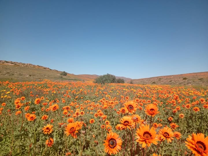
Autumn in South Africa brings mild days, cool nights and frequent morning mist. It’s the peak season for harvesting grapes as well as other fruit, with vineyards and orchards changing colour and offering scenic views. Elsewhere we find kilometres and kilometres of cosmos flowers in bloom.

And so Autumn remains one of the most pleasant seasons in South Africa, with moderate and comfortable weather across much of the country. Yet for many in the Cape provinces, the hope remains the same: that this Autumn will bring the rainfall needed to replenish reservoirs and provide relief ahead of the winter months.

Feeling like a season was extreme, and proving that it actually was extreme, are two different things. Vox Weather Meteorologist Michelle du Plessis takes a look at our recent summer season.

Let’s Look at the Data

Every summer, without fail, we hear it:

“This must be the worst summer ever.”
“It’s never been this hot.”
“I’ve never seen storms like this.”

And honestly – after a season of severe thunderstorms, flooding, heatwaves and damage – it’s completely understandable why people feel that way.

But here’s the important thing: feeling like a season was extreme and proving it was extreme are two different things. So we went back to the data – and what we found is fascinating.

Some regions genuinely did experience extreme, near-record (and even record-breaking) conditions. Others felt intense impacts without necessarily breaking long-term records.

Let’s unpack it.

Lowveld: One of the Wettest Summers Since 1979

The Lowveld recorded 528 mm of rainfall this summer.

That’s nearly 200 mm above the long-term average of 332 mm. In percentage terms, that’s 158% of normal rainfall.

When we rank every summer since 1979, only two were wetter:

1996 (647 mm)
2000 (591 mm)

That makes summer 2025/26 the 3rd wettest summer in nearly half a century.

So if you’re in Limpopo or parts of the Lowveld and it felt relentlessly wet – that’s not just perception. The data confirms it. This was genuinely one of the wettest summers on record for the region.

Upington: Hottest Summer on Record

Now let’s talk heat.

Upington recorded a mean summer maximum temperature of 37.36°C.

That’s +1.90°C above the 1991–2020 average.

When we ranked all summers since 1979, 2025/26 came out at number one.

Yes — the hottest summer on record in the CPC dataset.

This wasn’t just a few blistering days. It was sustained heat across the entire season. That’s what pushes a summer into record territory.

If you were in the Northern Cape and felt like this was next-level heat – the data agrees.


Richards Bay: Among the Hottest

Richards Bay didn’t break a record, but it came very close.

The mean summer maximum temperature was 30.28°C – about +1.46°C above normal.

That ranks as the 4th hottest summer since 1979.

Top four in nearly five decades is not small. It tells us this was clearly among the warmer summers on record for the region.

What the Temperature Anomaly Map Shows

If you look at the maximum temperature anomaly map, the story becomes even clearer. Large parts of the western and central interior are shaded in oranges and reds, indicating widespread above-normal maximum temperatures – in many areas between +1°C and +2°C above the 1991-2020 average. The Northern Cape stands out strongly, which aligns perfectly with Upington’s record-breaking summer.

Interestingly, parts of northern Limpopo show slightly cooler-than-normal anomalies. That helps explain why not every region felt the same level of heat intensity.

The map highlights something important: this was not a uniform heatwave across the country. Instead, it was a regionally amplified heat season, strongest over the western interior and parts of the Eastern Cape, while some northeastern areas were closer to average.

Rainfall: Below Normal in Many Areas – But Storms Were Intense

Now here’s where it gets interesting.

The rainfall map shows that many central interior regions actually recorded below-normal seasonal totals.

But that doesn’t mean the storms weren’t severe.

We saw multiple well-organised severe thunderstorm outbreaks this summer. There were mesoscale convective systems, large hail events, damaging winds and localised flooding.

Seasonal totals can sometimes hide intensity.

You can have:

  • Fewer rainfall days
  • Lower overall totals
  • But more intense rainfall events

And that’s exactly what parts of the country experienced.

So when people say, “The storms were worse than ever,” they’re reacting to intensity and impact – not necessarily total rainfall accumulation.

Perception vs Reality

This is why analysis matters.

Every season feels extreme when you’re living through it. The impacts are visible. The discomfort is real. The damage is real.

But ranking and long-term comparisons help us separate perception from measurable climate extremes.

So was it “the worst summer ever”?

Not everywhere.

But in some places, it absolutely ranks among the most extreme in nearly 50 years of records.