
Spring has arrived, bringing with it a new long-term agricultural weather outlook for South Africa. We once again look forward to the new season, as well as taking a quick look back on the winter that is now officially behind us.
Vox Weather Meteorologist Michelle du Plessis tells us more.
While parts of the country have already seen a wetter start to the season at the beginning of September, especially across the central and eastern regions, attention is increasingly turning to the strengthening El Niño and what it could mean for the coming summer.
Before looking ahead, however, it’s worth reflecting on a winter that was exceptionally dry across parts of the west.
A Notably Dry Winter In the West
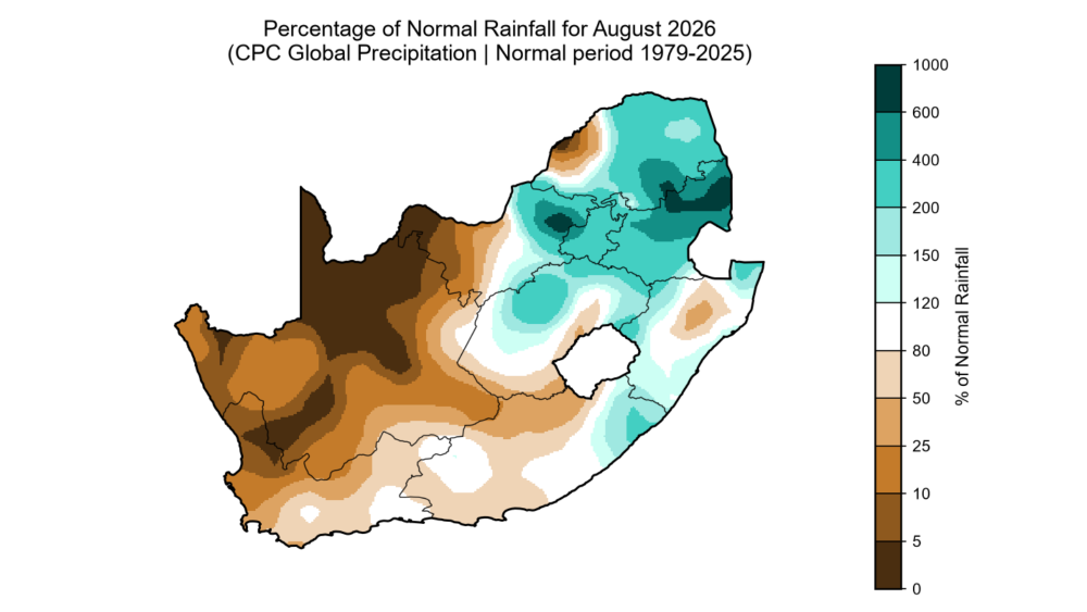
Large parts of the Northern Cape and western interior experienced an exceptionally dry August, with some areas receiving only around 25% of their normal rainfall for the month, and locally even less.
This is particularly significant for the winter rainfall region, where August still forms an important part of the traditional rainy season.
Further east, the picture was very different. A cut-off low brought widespread rainfall to parts of the country and was also responsible for some of the coldest conditions of the winter, including widespread snowfall.
Because August is normally a dry month across much of South Africa’s summer rainfall region, a single significant weather system can have a major impact on monthly rainfall totals.
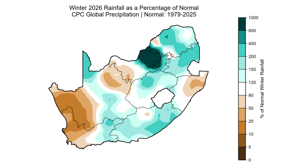
Looking at winter 2026 as a whole, the strongest dry signal was concentrated across the western parts of the country.
Large areas of the western Northern Cape, including parts of Namaqualand and the West Coast, experienced a very dry season, with some locations recording one of their driest winters on record.
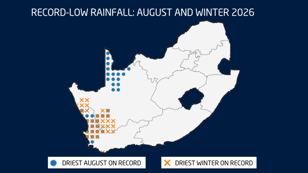
Record-low rainfall was particularly evident across parts of the Northern and Western Cape, with several locations recording either their driest August or driest winter on record.
Winter was also unusually warm
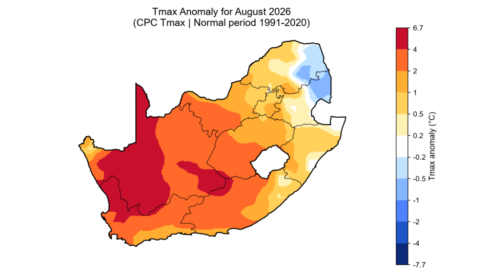
The winter was not only dry in many western areas, but also unusually warm.
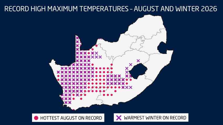
Analysis indicates that temperatures were between 2°C and 4°C above normal across large parts of the Northern Cape, as well as portions of the Western Cape, North West, Free State and northern Eastern Cape.
Several locations recorded their warmest August on record, while others experienced their warmest winter on record.
The strongest concentration of record warmth was found across the Northern Cape and western parts of the Western Cape, although records were also observed in parts of the Eastern Cape and Free State.
A Wet and Unsettled Start to September
The first week of September brought a sharp change in conditions, with a strong cut-off low developing over the country.
Cold, wet and windy weather occurred across several provinces, with heavy rainfall over parts of North West, the Northern Cape and Free State.
Rain also occurred across parts of the Karoo, the south coast, Eastern Cape, KwaZulu-Natal and Lesotho, while some rainfall extended as far north as Gauteng, Limpopo and the Highveld.
The heaviest falls fell over the central North West and neighbouring parts of the Northern Cape and Free State, with accumulated rainfall approaching 100 mm in some areas by Sunday evening 06 September, which raised the risk of flooding.
Could September Bring a Wetter Overall Start To Spring?
Seasonal guidance suggests that wetter-than-normal conditions may continue across parts of central and eastern South Africa during the first half of September. Above-normal rainfall is possible over eastern parts of the country during the second week of the month, with the wetter signal continuing across sections of the central and eastern regions into the third week.
By the final week of September, the pattern becomes more mixed, with below-normal rainfall possible along parts of the south and east coasts, while wetter conditions may occur across Limpopo, North West, the Northern Cape, Eastern Cape and Free State.
It’s important to remember that spring is a transition season. As atmospheric instability increases, thunderstorms can become more intense, bringing not only heavy rain, but also hail and strong wind gusts.

El Niño continues to strengthen
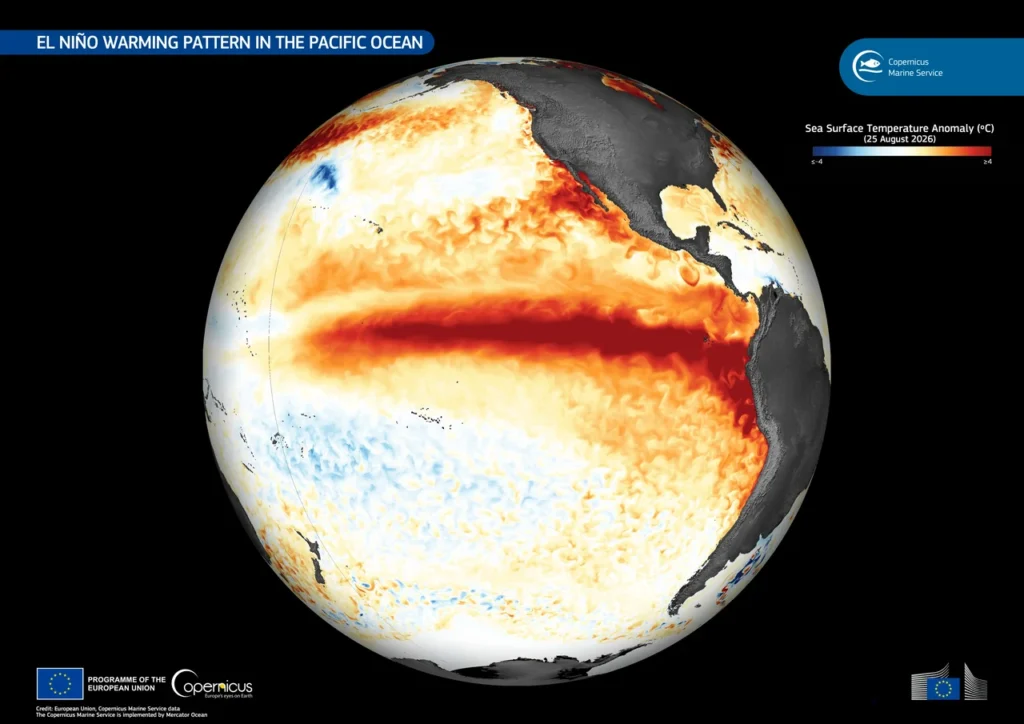
El Niño has strengthened further in recent weeks and is now firmly established. The latest relative Niño 3.4 index stands at around +2.45°C, while seasonal models indicate that further strengthening is possible through spring.
There are even indications that this event could reach exceptionally strong levels.
For South Africa, El Niño is typically associated with an increased risk of warmer and drier conditions across the summer rainfall region, particularly later in the season. However, El Niño does not automatically mean drought.
There can still be periods of significant rainfall, and individual weather systems can bring substantial rain even during an otherwise dry season. (Image: Wikipedia)
Spring rainfall outlook remains uncertain
The latest seasonal forecasts currently provide mixed signals for spring.
The South African Weather Service indicates an increased chance of above-normal rainfall across parts of the Northern Cape, Free State, Eastern Cape, KwaZulu-Natal and Highveld during the September-to-November period.
The University of Pretoria outlook, however, paints a different picture, indicating below-normal rainfall across large parts of the country.
Forecast skill for spring rainfall remains relatively weak, meaning confidence in these rainfall projections is still low. For now, considerable uncertainty remains around exactly how the spring rainfall season will unfold.